Winter storm watch issued for local Md./Pa./W.Va. area Friday night into Saturday morning
UPDATE: The National Weather Service has issued a winter storm watch for the Tri-State area from 7 p.m. Friday through 7 a.m. Saturday.
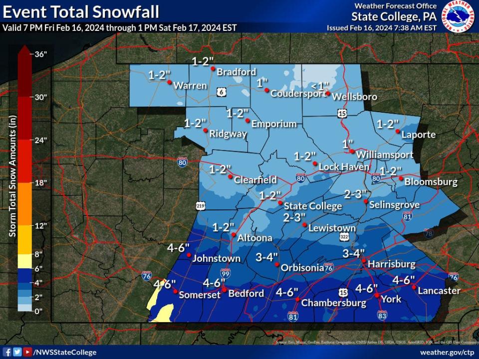
Forecasted snow totals have increased for southern Franklin County. As of Friday morning, that area was expected to get 3 to 5 inches of snow overnight into Saturday, said meteorologist Aaron Tyburski with the State College (Pa.) Forecast Office.
Light flurries were still expected to start in the early evening with most of the snow forecast to start around 11 p.m. to midnight Friday in the Tri-State area and end around sunrise, meteorologists said.
There could still be lingering snow in the morning, but the storm is expected to move quickly to the coast and out to sea, Tyburski said.
The main center of the storm is south of Pennsylvania, he said.
More: Forecasted inclement weather in Md./Pa./W.Va. area causes cancellations. Here's the list.
The high Saturday is anticipated to be in the low to mid 40s in the Hagerstown and Martinsburg, W.Va., areas and around 36 degrees to 38 degrees in southern Franklin County, according to Tyburski and the weather service's online forecasts.
Those highs, along with clear skies, will help melt the snow where it's been plowed and shoveled, he said.
=================================
The Tri-State area could see another few inches of snow Friday night into Saturday.
But this time the snow is expected to be the fluffier type, not the heavy wet snow area residents saw Tuesday, National Weather Service meteorologists said.
Before the snow arrives, gusty winds are forecasted to continue through Thursday night.
The weather service issued a wind advisory, until 10 a.m. Friday, for several Pennsylvania counties, including Franklin and Fulton.
Gusts could reach up to 45 mph to 50 mph, said meteorologist John Bowen with the State College (Pa.) Forecast Office.
In Washington County and West Virginia's Eastern Panhandle, guests could reach upward of 20 mph to maybe 40 mph, said meteorologist Austin Mansfield with the Baltimore/Washington Forecast Office.
'End of life' bill heard in Maryland: ‘End-of-Life Option Act’ draws passionate testimony before Maryland Senate committee
How much snow should the Tri-State area expect?
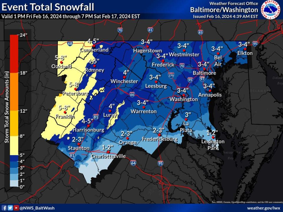
Washington County and local West Virginia residents could see 3 to 4 inches of snow, Mansfield said. The worst case would be around 6 inches.
Add another inch if you're in the higher elevations of the Catoctin Mountains near northwest Frederick County, Md.
In southern Franklin County, folks could see 1 to 3 inches of snow, Bowen said.
The snow could arrive around 7 p.m. Friday and be mostly done by around sunrise Saturday. There could be lingering flurries after that on Saturday morning.
"As always with snow there comes that inherent slippery risk on roadways and definitely on overpasses as you get some of that snow melting as cars drive over it and (it's) refreezing with the cold," Bowen said.
This article originally appeared on The Herald-Mail: NWS increases predicted snow total for Greencastle area

