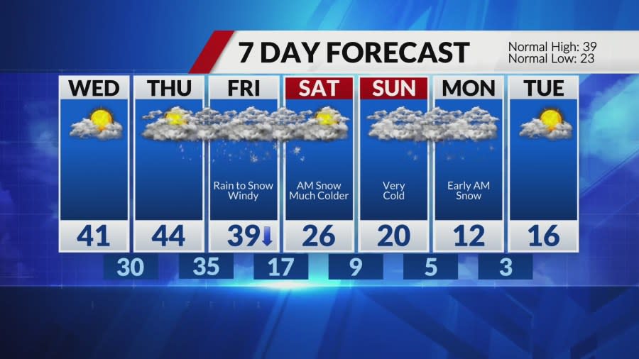
More snow expected by Friday; bitter cold to follow

ST. LOUIS — The final phase of our latest storm will bring a change from cold rain to light snow and flurries this afternoon. Winds will also be increasing later today into this evening as well. Additional accumulations will be less than 1″ in the St. Louis metropolitan area, with a couple of inches possible further north, back up towards Troy and Bowling Green. Temperatures will slowly fall back into the low 30s by the evening rush. Roads are likely to range from wet to somewhat slushy, especially along and north of I-70 heading into the evening rush.
St. Louis radar: See a map of current weather here
The next system is quickly catching our attention for Thursday night into Friday. It looks like a rapidly evolving system that will again start as rain on the front end but then turns to snow. This storm has a lot more cold air on the backside, which, if it arrives faster, could lead to more significant snow potential. However, at this point, evolution is still uncertain and trends point to light to moderate snow.
What may become the bigger story will be the strong winds on the backside of the system and the bitterly cold air arriving with it. The coldest air of the season arrives for the weekend. By Sunday, daytime temperatures may struggle to warm out of the teens, with overnight lows dropping low into the single digits.
There may be another system to deal with Sunday into Sunday night, and if this one pulls together, it will all be snow thanks to the bitter temperatures that will be in place.
For the latest news, weather, sports, and streaming video, head to FOX 2.


