More snow on the way? See forecast and how much central PA could get this weekend
As frigid temperatures persist in central Pennsylvania, snow is back in the forecast once again.
According to AccuWeather’s online forecast, snow is expected to begin around 3 a.m. Friday before concluding at approximately 10 p.m. The State College area can expect to observe between 1 and 3 inches of snow.
“It should be a very dry, powdery snow, so, for those who need to shovel, it should be very easy to move around,” said Tom Kines, a senior meteorologist at AccuWeather. “After the snow moves away, the wind is going to pick up. Saturday ought to be a blustery day around here, and that will help snow blow and drift around. For those who want to be or have to be out on Saturday, the actual temperature is likely only in the teens.”
Here's a look at what radar might look like tonight and tomorrow as snow moves through Pennsylvania. The snow will be light and fluffy:
️ Good for skiing & shoveling
️ Bad for snowballs, snow forts, & snowmen#PAwx pic.twitter.com/QPSLiZz7h3— NWS State College (@NWSStateCollege) January 18, 2024
The National Weather Service issued a winter weather advisory for much of Pennsylvania that will remain in effect from 1 a.m. Friday to 1 a.m. Saturday. The agency said it expects total snow accumulations between 2 and 4 inches that could result in slippery road conditions that may impact morning or evening commutes.
Relief from January’s freezing temperatures might be on the way soon. Respective high temperatures of 19 and 27 degrees Fahrenheit on Saturday and Sunday will give way to high temperatures in the upper 30s and even mid-40s by next Friday, according to AccuWeather’s projections. High temperatures are expected to return to the low 30s by the end of January.
“We’ve been spoiled the past couple of winters around here,” Kines said. “Any cold that we’ve had has been brief, and at least over the past couple of weeks, it seems to be lingering. The good news is that, by next week, the cold might move out of here for a little while as temperatures moderate.”
Is it legal to let your unattended car warm up in PA’s cold weather? What the law says
How much has it snowed in Pennsylvania this winter?
Following a slow start, snow has been piling up in the Centre County area over the past few weeks.
State College has observed roughly 11.7 inches of measurable snowfall so far this season, according to NWS online archives. A “normal” season typically produces about 16.1 inches of measurable snowfall through Jan. 18.
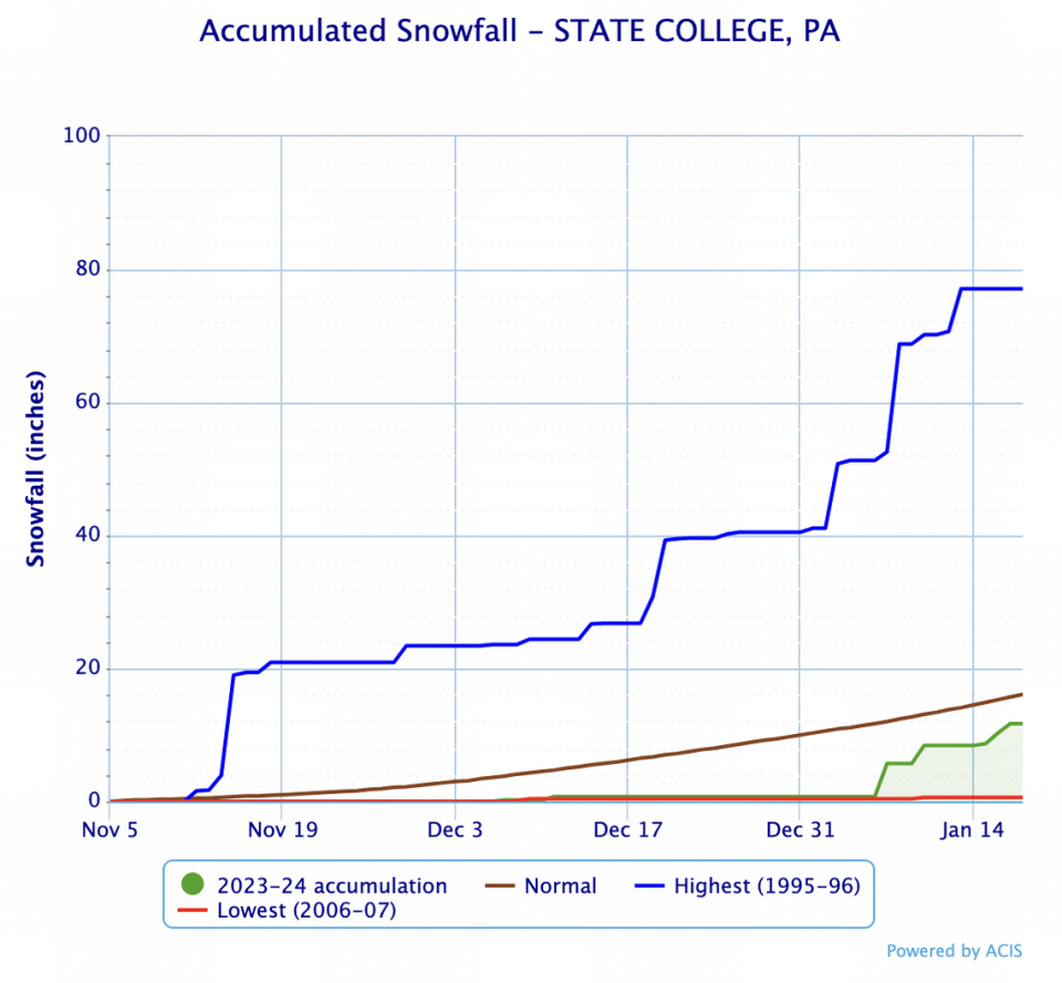
No season saw more snow between early November and mid-January than the 1995-96 season, which observed approximately 77.1 inches of measurable snowfall in State College by this point in the year. The 2006-07 season set a record-low through mid-January with just 0.6 inches of measurable snowfall.
El Niño, a notable climate pattern that has the potential to significantly influence weather by altering jet streams and climate systems, is expected to continue through most of the winter, according to the National Oceanic and Atmospheric Administration’s Climate Prediction Center. Most of the U.S., including Pennsylvania, can likely expect a warmer, drier winter with above-normal temperatures.
When forecasting the winter season back in November, AccuWeather senior meteorologist Bob Smerbeck told the Centre Daily Times the agency expects a milder winter for central Pennsylvania compared to seasonal averages.

