Most of Southwest Florida is still in a drought, but rains are expected this weekend
Parts of Southwest Florida have been hit with several inches of rain this month, and more precipitation is on the way as the rainy season started this week.
May 15 is the average day on which regular rainfall patterns start in the Sunshine State; thus meteorologists have dubbed that date as the official start of the season, although daily rain patterns can start before or after May 15.
That pattern could kick into gear soon as rain is expected this weekend across Southwest Florida.
"It's tropical moisture and it's coming up from the tropics," said Paul Close, a meteorologist with the National Weather Service in Ruskin, which covers the Fort Myers-Cape Coral area. "There's nothing organized, but there will be a lot of moisture, and it will feel really humid."
Rain chances for Fort Myers start today and extend into Saturday. And more is on the way.
"It's looking like Friday morning and midday the storms will move to the East Coast," Close said. "Saturday is a more typical type of day with southeast flow, and it will develop and then move across the state."
Rainy season reminder: Rainy season reminder: Florida motorists can use hazard lights in severe weather
Record rainfall: Fort Myers's record rainfall could indicate transition to rainy season starting
SWFL still in drought: Recent rains welcome as region suffers through severe drought; more to come this summer
Florida weather: Changing climate expected to bring more severe rain, stronger storms to Sunshine State
Close said the first few weeks of the rainy season are a mixed bag: rains may fall for several days, then stop for a week or more.
"It's transitioning," Close said. "It's not like all of a sudden one day you get storms. Sometimes you'll get four or five days of rain and then it will not rain for two weeks."
Close said soon the area will see daily afternoon onshore breezes and morning thunderstorms developing well offshore.
That cycle seems to start once open ocean water temperatures in the Gulf of Mexico reach 82 or 83 degrees, Close said.
"You wake up in the morning in June, and if we have east winds you'll see towers and thunderstorms offshore," he said.
Most of Florida needs that rain as drought conditions are still in place for many locations.
The Naples area will see a 70% chance of rain Friday and Friday night, with rain continuing in some areas on Saturday.
"We did see moisture from the Caribbean move into South Florida," said Larry Kelly, a meteorologist with NWS in Miami, which covers the Naples area. "Friday is the highest chances of rain and that extends to Saturday as well. There's more moisture across the area and more showers across the area."
Kelly said localized rain amounts could be 2 inches or more.
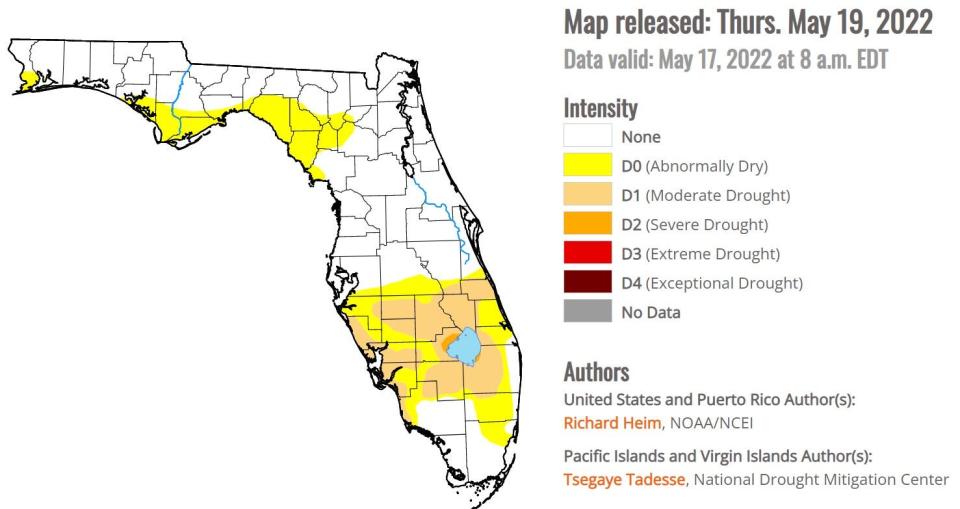
Most of coastal Southwest Florida still in moderate drought
National Oceanic and Atmospheric Administration, or NOAA, says most of coastal Southwest Florida is still in a moderate drought, as are the farmlands surrounding Lake Okeechobee. NOAA's May 19 report shows severe drought conditions to the northwest and southeast of the big lake.
La Nina has played a role in the drought, bringing warmer, drier conditions to this region during the winter and spring.
The weather phenomena also influences the tropical storm and hurricane season by creating an atmosphere that's more favorable to storm development.
SWFL shoreline birds: Vulnerable to beachgoers, nursing the next generation
Animals on the move: Warmer months mean many of Florida's majestic animals are on the move, preparing for summer
Rats in Florida: Rats in Florida: The good, the bad and ugly about the pesky rodents who call our state home
Water School: FGCU's Water School comes to life, opens to students later this year
La Nina doesn't impact our day-to-day weather in the summer months, Close said.
Overall, the dry season produced nearly 15 inches of rain, on average, for the Lee-Collier area, according to the South Florida Water Management District.
That's 0.7 inches below average for the period, which lasts from Oct. 15 to the following May.
For farmers and ranchers, the rain is a welcome sign of wetter times to come.
"It will be nice," said Gene McAvoy, with the University of Florida's Agriculture Extension in LaBelle. "We're wrapping up in sugarcane and a lot of the veggies are done, but we could use some rain for pastures and things like that."
Rising temperatures and humidity will be the next trademarks of summer, Close said.
"This morning (Thursday) it seemed really stuffy," Close said. "The air seemed dead and the dew point was only 72 and that's not that bad. In July it will be 80."
Connect with this reporter: @ChadEugene on Twitter.
This article originally appeared on Fort Myers News-Press: Fort Myers, Naples weather: Rain on tap for weekend as drought remains

