Mt. Charleston floods took out 856-foot section of road, damaged most popular trails in Kyle Canyon

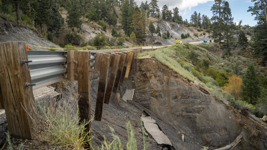
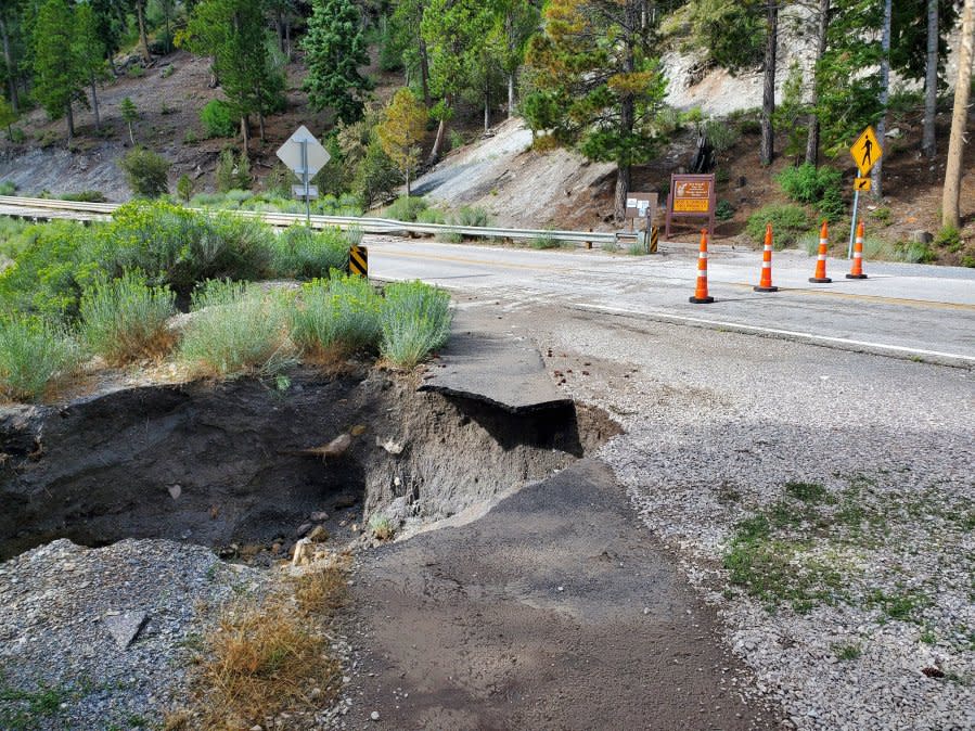
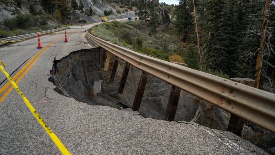
LAS VEGAS (KLAS) — An 856-foot section of Kyle Canyon Road was completely washed out near the Rainbow Canyon area when a series of storms caused massive flooding on Aug. 21. It was one of 43 sections of road damaged by storms associated with Tropical Storm Hilary.
Kyle Canyon Road (SR-157) and Lee Canyon Road (SR-156) have remain closed to visitors since the floods caused heavy damage.
The Nevada Department of Transportation (NDOT) reports repairs have been completed on Lee Canyon Road. Emergency repairs on Kyle Canyon Road are continuing and crews are on track to finish that work this week. The roads will remain closed by order of the U.S. Forest Service, NDOT said. Roadwork, construction and debris removal activities are continuing.
Deer Creek Road (SR-158), which links Kyle Canyon and Lee Canyon, is still closed. The road is “inaccessible due to the extreme hazards posed by the current road conditions,” NDOT said. Emergency construction is scheduled to start on SR-158 next week and is anticipated to be complete before winter.
Extensive damage and debris including large boulders, dead trees and deep channels “now exist where trails used to be,” according to an NDOT news release. Among the damaged trails:
Mary Jane Falls
Cathedral Rock
Acastus
Bristlecone Pine
Fletcher
“Safety remains our top priority,” Deb MacNeill, Spring Mountains National Recreation Area Manager, said.
“Some of the most popular trails in Kyle and Lee Canyon were hit hardest by the storm and damage is significant. We continue emergency stabilization efforts and repairs and will keep the public informed of our progress.”
The statements were the first details of the damage to one of the Las Vegas valley’s most popular destinations, a place where people go to get out of the heat and reconnect with nature.
The Carpenter Canyon and Wallace Canyon roads remain inaccessible even by 4×4 vehicles due to significant flooding washouts. Damaged trails are expected to remain closed until cost estimates for repairs or rerouting can be finalized and funding is allocated for related costs.
Recreation areas remain open at Cold Creek, Willow Creek, Potosi, Cottonwood Pass, Lovell Canyon, Wheeler Wash, Mt. Stirling and Johnny. Visitors are advised to check current weather conditions prior to heading into the back country.
The Forest Service closure notice includes the Spring Mountains Visitor Gateway and all trails, picnic areas and campgrounds on land managed by the Forest Service. More information, including a closure map, is available at https://www.fs.usda.gov/htnf. Only working crews, local residents and private businesses have access.
People who violate the closure face severe fines.
Flood recovery taking time for resident in southeast Las Vegas valley
“NDOT, the Las Vegas Valley Water District and other agencies have made tremendous progress on making repairs on the mountain, but there is still a lot of heavy equipment coming and going as work and debris removal activities continue,” Fire Chief Jorge Gonzalez, who oversees the Mount Charleston Fire Protection District, said. “We also have serious concerns about people getting injured if they attempt to hike or recreate on closed areas within the forest because of the damage.”
For the latest news, weather, sports, and streaming video, head to KLAS.

