Much colder air and the prospects of snow around Halloween will frighten some in the Northeast

A strong cold front and a pair of storms will usher in a significant pattern change in the Northeast to end October and begin November. For many, this will include the season's first snow and a freeze that will end the growing season, warn AccuWeather meteorologists.
The air, already settling in over the Midwest, will feel more appropriate for early December rather than the end of October, quite a shock for those in the East who have been experiencing early September-like warmth of late.
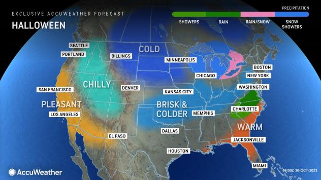
The blast of colder air and the frightening prospects for even some accumulating snow around Halloween may literally send chills down the spines of trick-or-treaters, and have those heading out in the days after reaching for their heavier winter coats and cold weather gear each morning.
 |
While many in the Northeast may dodge accumulating snow this week, everyone will have to endure a dramatic drop in temperature, say AccuWeather meteorologists.
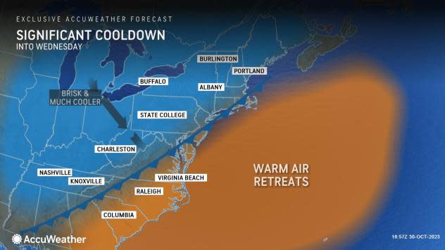
"After many cities experienced record-challenging warmth last week, a major flip in the pattern is expected this week," said AccuWeather Meteorologist Brandon Buckingham. "High temperatures can be more than 30 degrees lower than last week across a wide swath of the Northeast." The overall temperature drop from highs during the height of the warmth to lows in the pit of the chilly may be close to 50 degrees in some locations.
From Washington, D.C., to Boston, temperatures soared into the 80s for a final day on Saturday, challenging or even setting new record highs in some cities. Such readings were about 20 degrees above the historical average for late October.
 |
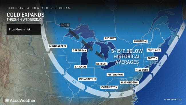
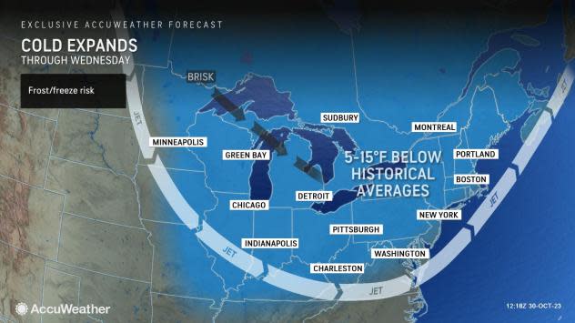
Cooler air arrived on Sunday in much of the Midwest and central and northern Appalachians amid rounds of rain. The rainy and cooler weather will persist into Monday night, along with temperatures more typical of the end of October across the interior. Waiting in the wings, however, will be an even more significant blast of cold air set to arrive on Halloween and last through the first few days of November.
In Pittsburgh, temperatures that were well into the 70s much of last week will be replaced by 40s for several days beginning on Halloween Tuesday. A drop in mercury of a similar magnitude can be expected in Philadelphia and New York City, where 80s will be replaced by highs in the upper 40s and low 50s for several days.
The temperature drop at night will be even more noteworthy, representing the chilliest air since last spring and the end of the road for the growing season for many.
 |
Late at night and in the morning for several days during the early and midweek period, residents of Columbus, Ohio, will be shivering amid temperatures in the 20s, bringing the first hard freezes of the season. Similar readings can occur all across the interior of the Ohio Valley, mid-Atlantic and Northeast.
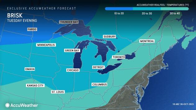
Come trick-or-treating time on All Hallows' Eve, those with heavier costumes with many layers will have a heads up on staying warm compared to their compatriots who don't. Temperatures will be in the 30s Tuesday evening across most of the interior and 40s in the big cities along I-95 and near the coast. A gusty breeze blowing as the chillier air is ushered into the region mean AccuWeather RealFeel® Temperatures will be at least 10 degrees lower than the actual thermometer readings.
As is typical with any big change in temperature, Mother Nature will deliver a few doses of moisture this week, and this time it will come in the form of both rain and snow, say AccuWeather meteorologists.
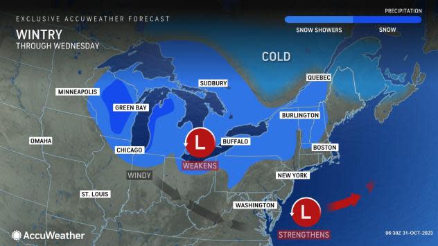
"In addition to the surge of cold air, an incoming Alberta Clipper storm is expected to bring the first snowflakes of the season for many locations across the interior Northeast between Halloween and Wednesday," said Buckingham.
Have the app? Unlock AccuWeather Alerts™ with Premium+
An Alberta Clipper is a swift-moving, chilly storm that originates from Alberta in southern Canada, and then sweeps across the Midwest and Northeast. While these storms often lack moisture, they can reinforce the chilly air and bring quick accumulations of snow.
The Alberta Clipper will actually be the second of three features that will bring rain and snow to the region this week, after a cold front and ahead of a developing storm off the Northeast coast.
 |
Northern New England will be the first to deal with accumulating snow as the pattern-changing cold front moves through into Monday evening. Ahead of the expected snow, the National Weather Service hoisted winter weather advisories in central and northern Maine, where rain can change to snow and accumulate several inches through the evening.
The focus for wintry weather will then shift back toward the Midwest as the clipper storm swings through. Snow showers will began to impact parts of northern Michigan on Sunday afternoon and night and will spread over most of the rest of the Great Lakes region into Monday night.
In Hancock, Michigan, located in the northern part of the state, heavy snow showers occurred on Monday morning with a temperature in the upper 20s and AccuWeather RealFeel® Temperatures in the upper teens.
"Depending on the timing of the incoming clipper, a few snowflakes may be flying as kids head out for trick-or-treating," said Buckingham. "This can occur in places like Cleveland and Buffalo."
While accumulations will be minimal due to ground surfaces remaining warm from the weather of last week, a slushy coating to an inch or so of snow cannot be ruled out, especially in heavier snow bands that form downwind of the Great Lakes into early Wednesday, predicted Buckingham. This can especially be the case in the typically favored parts of northwestern Indiana, northeastern Ohio, northwestern Pennsylvania and western New York.
 |
Perhaps of greatest intrigue to meteorologists this week will be the prospects of a coastal storm forming along the Northeast coast, as atmospheric energy is transferred offshore from the Alberta Clipper.
AccuWeather meteorologists say that a big winter storm is not anticipated as low pressure forms near the coast, because the blast of chilly air moving east will be significant enough to keep most of the impactful moisture offshore. Despite that, a period of chilly rain can still brush the coast from Delmarva to southeastern New England from Tuesday into Wednesday, including along the Jersey Shore, on Long Island and in places like Providence and Boston.
On the northwestern flank of the coastal storm, the air will be cold enough to allow a period of wet snow from about northernmost New Jersey to the Catskills, Taconics and Berkshires on Tuesday night. These areas also stand the best chance of a small accumulation on non-paved surfaces. Some wet snowflakes may mix in over part of the lower Hudson Valley, the Connecticut Valley and the higher elevations well west of Boston.
Across the interior, flurries and locally heavier snow squalls will ramp up and riddle the interior Northeast from later Tuesday to Wednesday night as chilly air continues to filter in. In the past, similar setups have triggered dangerous conditions on some of major highways, where a sudden drop in visibility accompanies a quick slushy accumulation of snow.
The prospects of cold air will likely mean that ski resorts in New England can open as early as this week as earlier projected since conditions will be favorable for snow-making.
 |
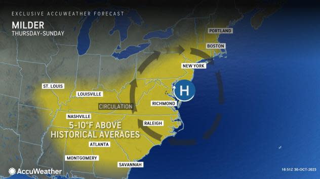
Eventually, milder air will return to the mid-Atlantic and Northeast late in the week and next weekend, as an area of high pressure moves toward the coast. This will result in temperatures that were 5-15 degrees below the historical average rising to 5-10 degrees above average.
Want next-level safety, ad-free? Unlock advanced, hyperlocal severe weather alerts when you subscribe to Premium+ on the AccuWeather app. AccuWeather Alerts™ are prompted by our expert meteorologists who monitor and analyze dangerous weather risks 24/7 to keep you and your family safer.
