How much North Texas snow before a winter storm warning is called? Criteria have changed
As winter approaches North Texas, the criteria with which the National Weather Service uses to send out winter storm warnings have been revamped.
The type of alert sent out depends on the inches of snowfall expected in the area. With this, how much snow has to fall in the Dallas-Fort Worth area before a critical winter storm warning is sent out?
Here’s what a map just released by the NWS outlining the new criteria tells us about when storm warnings will be sent out in Texas.
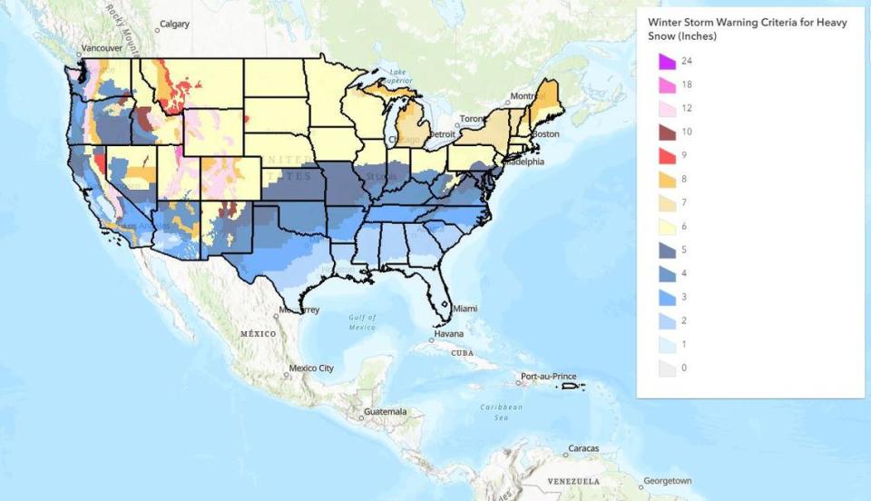
In the Texas Panhandle as well as parts of West Texas, the heavy snow criteria is four to five inches, for which a winter storm warning is issued. As for Central Texas, heavy snow is considered to be three inches, so that’s when a warning will be issued. As for South Texas, the criteria for a warning is one to two inches of snowfall.
Winter weather alerts the National Weather Service sends out
Here are the different winter weather warnings, watches and advisories that the NWS sends out:
Warnings: Take Action
Winter Storm Warning: Issued when hazardous winter weather conditions are occurring or expected to occur within 12 hours.
Blizzard Warning: Issued for frequent gusts greater than or equal to 35 mph accompanied by falling and/or blowing snow, frequently reducing visibility to less than 1/4 mile for three hours or more.
Freeze Warning: Issued for the first occurrence of freezing temperatures in the fall, for late freezes during the spring or for a freeze expected to occur after a prolonged warm spell.
Ice Storm Warning: Issued for ice accumulation of around 1/4 inch or more.
Wind Chill Warning: Issued for a combination of very cold air and strong winds that will create dangerously low wind chill values.
Lake Effect Snow Warning: Issued when widespread or localized lake induced snow squalls or heavy showers are expected to produce significant snowfall accumulation.
Watches: Be Prepared
Winter Storm Watch: Issued when the following conditions are possible within 12 to 36 hours: heavy snowfall of 4 or more inches in 12 hours or 6 or more inches in 24 hours; freezing rain and/or freezing drizzle accumulating to a depth of 0.25 inches or greater; or heavy sleet accumulating to a depth of 1/2 inch or more.
Wind Chill Watch: Issued when there is the potential for a combination of extremely cold air and strong winds to create dangerously low wind chill values.
Advisories: Be Aware
Winter Weather Advisory: Issued when any or all of the following are expected: Snow accumulations less than 4 inches in 6 hours, or less than 6 inches in 24 hours; freezing rain accumulation less than 0.25 inch; freezing drizzle with little or no accumulation.
Wind Chill Advisory: Issued when forecast wind chill values will be below -20 degrees.
Lake Effect Snow Advisory: Issued for widespread or localized lake effect snowfall accumulation and blowing snow remaining below warning criteria.

