Tornado Alley under multi-day severe weather threat


Cities like Oklahoma City, Dallas and Wichita, Kansas, all places situated in the area of the Plains known as Tornado Alley, are being urged by AccuWeather forecasters to remain on alert as a series of storms will likely continue spawning severe weather.
As of Oct. 4, there had been 1,007 preliminary reports of tornadoes across the country according to the National Weather Service's Storm Prediction Center. Leading the count was Texas with 109 reported tornadoes and a close second was Alabama with 92 reported twisters. That number already began rising on Sunday night as severe weather broke out in Oklahoma.
And the threat is expected to grow Monday into Tuesday. A series of disturbances rolling out of the western United States is expected to feature all of the ingredients necessary for dangerous thunderstorms.
"Cool, dry air from out of the Rockies is expected to clash in the southern Plains with warm, moist air originating from the Gulf," AccuWeather Meteorologist Adam Sadvary said. "These ingredients will lead to a battleground of severe weather."
The severe weather kicked off on Saturday evening in the northern Plains. A tornado touchdown was reported by the fire department in Day County, South Dakota, and reports of hailstones reaching up to golf ball size were made farther south in the state.
The threat increased significantly on Sunday across the southern Plains. On Sunday afternoon, wind speeds picked up in Lamb County, Texas, reaching 60 mph in Earth, Texas, and 73 mph in Amherst, Texas. According to the NWS, the wind gusts were accompanied by a thunderstorm passing through the area.
Hail reports were first made early Sunday evening at the Altus Air Force Base in Jackson County, Oklahoma. A potential tornado was spotted nearby in Kiowa County, Oklahoma, where the National Weather Service (NWS) reported swirls visible at the surface.
 |
Dallas, Oklahoma City and Tulsa, Oklahoma, were just a few of the cities that continued to be in a favorable zone for severe thunderstorms as the night progressed. By 9:59 CDT Sunday evening, a Tornado Watch had been issued for the Tulsa area after a radar-confirmed tornado touched down near Bixby, Oklahoma, a town just southeast of Tulsa. A possible tornado in Coweta, Oklahoma, led to at least one injury overnight Sunday, according to local authorities.
After the severe threat diminishes, a much calmer day is in the forecast for the South Central states on Monday; however, the same cannot be said across the Midwest as the threat for severe weather will shift northeastward.
Once again, many major metropolitan areas will lie within the zone of expected severe weather on Monday. St. Louis, Chicago and Grand Rapids, Michigan, fall within the zone of expected thunderstorm activity.
Very fast winds well above the surface of the ground will translate down to fast-moving thunderstorms at the surface. For any warning issued in these portions of the Midwest on Monday, there will likely be limited time to react, as thunderstorms could be clipping along at 50-60 mph. With a storm motion of this nature, damaging wind gusts may be the most widespread concern; however, hail, flooding downpours and even an isolated tornado or two cannot be ruled out.
"These storms could be ill-timed with the evening commute home for many people with the threat for downpours and damaging winds," AccuWeather Senior Meteorologist Dan Pydynowski stated. "In addition, the White Sox will be hosting the Astros for game 4 of the ALDS with a first pitch scheduled at 2:37 p.m. CDT. The storms could cause some delays to this game due to rain or lightning, especially during the latter innings."
By Tuesday, the risk for severe weather will diminish across the Midwest as the storm in the upper levels of the atmosphere responsible for spawning the thunderstorms will lift off into Canada.
 |
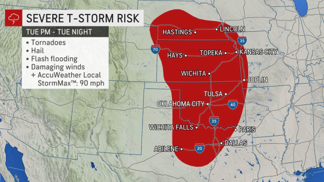
The multi-day severe weather threat will continue on though, as conditions will become primed for explosive thunderstorm development across the southern and central Plains once again.
This storm has the potential to be more widespread across the central U.S., and any cleanup efforts that may result from the first wave of storms could be short-lived.
Once again, all modes of severe weather including damaging wind gusts, large hail, tornadoes and flooding downpours are expected Tuesday and Tuesday night.
Severe weather that occurs at night presents additional hazards. A large portion of the population sleeps during the overnight hours, so it is important that people at risk to get severe weather have multiple ways to receive potentially life-saving weather alerts in order to find shelter in a moment's notice.
Severe weather activity can spike during the fall
Many across the U.S. may typically associate the spring and summer months with the development of severe weather, but fall is capable of being just as potent.
 |
The spring season represents the largest peak in frequency of severe weather activity for the United States, but meteorologists say that there is a secondary, smaller peak that occurs during the fall season.
During the autumn, chilly air is ushered southward as cold fronts dive out of the Rockies and into the Plains and collide with the steamy air that flows northward out of the Gulf of Mexico. When these two contrasting air masses meet, the results are often explosive.
For the latest weather news check back on AccuWeather.com. Watch AccuWeather Network on DIRECTV, DIRECTVstream, Frontier, Spectrum, fuboTV, Philo, and Verizon Fios. AccuWeatherNOW is streaming on Roku and XUMO.
