'Multi-vortex!' Here's how Melbourne storm chasers filmed a tornado spawned by Hurricane Ian
As the ominous rotating wall cloud approached U.S. 192, Florida Institute of Technology meteorology student Gabe Taylor parked his Nissan Sentra in amazement 100 to 150 yards away, watching small funnels spin to life and lift tree debris skyward.
“Wow. Oh my gosh, dude!" Taylor said, shooting video on his iPhone.
"Multi-vortex!" he said.
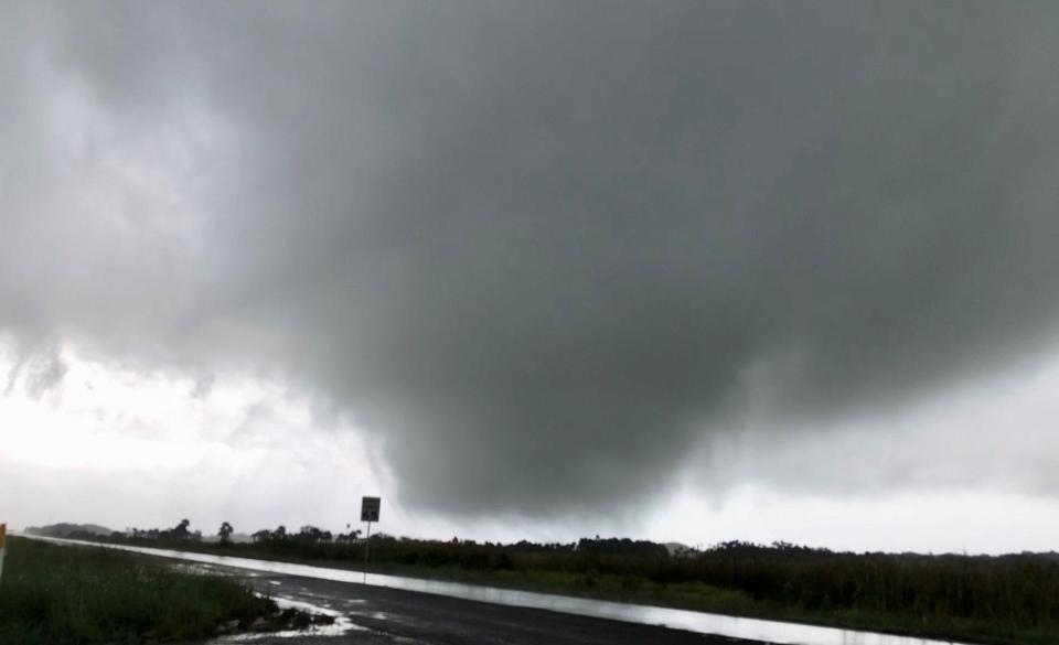
Taylor filmed rare video of the Hurricane Ian-triggered twister tearing across sparsely inhabited cattle pastures, forests and marshlands Wednesday afternoon in westernmost Brevard County, roughly 9 miles west of Interstate 95.
The tornado crossed U.S. 192 just after 3:30 p.m. between Bumpy Road (in Brevard County) and Sapling Lane (in Osceola County). These nearby twin-track dirt roads with cattle gates are unmarked by street signs.
3:35PM - multiple sub-vortices as it crosses the road, I decide to get a little closer and drive onto the road (don't worry, I checked that no cars were coming). The tornado is heading northwest as it crosses. pic.twitter.com/PYsaEQZb8t
— Gabriel Taylor (@gtaylor_wx) September 28, 2022
Rescue mission: 920th Rescue Wing awaits possible rescue missions after Hurricane Ian floods Florida
'I'm nervous': Some Brevard residents hunker down for Hurricane Ian in county shelters
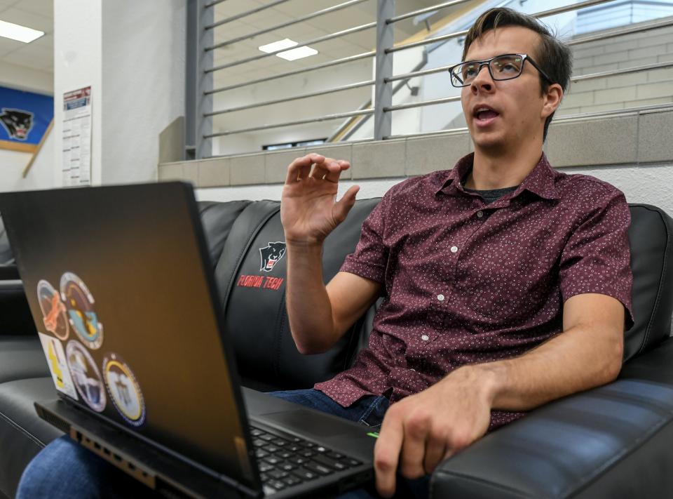
"I pulled over, and I started filming. And that's when I realized it was rotating extremely fast — realizing that I'm seeing my first tornado," Taylor recalled, reviewing his video footage on his laptop.
“There's the rotating wall cloud, and there were multiple vortexes spinning around the base of the tornado. The tornado is approaching my car there. I can't really believe what I'm seeing," Taylor said.
"At this point, the tornado is just starting to get into the road. And I can hear that iconic roar that you hear when there's a tornado real close," he said.
Taylor continued following the twister's northwesterly path by driving up nearby Deer Park Road. All told, he estimates he watched the cyclonic storm's squally evolution for roughly 15 minutes.
As of Friday afternoon, the U.S. 192 tornado remained the only confirmed twister that was generated by Ian in Brevard County, said Tim Sedlock, a National Weather Service lead meteorologist at the Melbourne station.
Sedlock said it was likely an EF-0 tornado with winds up to 72 mph. These tornadoes can uproot shallow-rooted trees, break off tree branches, and damage chimneys, according to the Fujita Scale of damage intensity.
No injuries or structural damages were reported, Sedlock said.
“One of the rain bands from Ian came onshore, moved up through southern Brevard, and eventually crossed over from west-central Brevard County into eastern Osceola County,” Sedlock said.
“There were some trees that were probably uprooted there, looking at the video," he said.
Tornado Warning including Deer Park FL until 3:00 PM EDT pic.twitter.com/JQSHTuBPhk
— NWS Melbourne (@NWSMelbourne) September 28, 2022
At 2 p.m. Wednesday, the National Weather Service issued a tornado warning for a tract of western Brevard and Indian River counties, leading southward near Yeehaw Junction.
NWS forecasters issued subsequent warnings over the next hour as the danger zone migrated northward to the Deer Park-Kenansville area. The EF-0 twister eventually touched down within that zone's northeastern corner.
Melbourne storm chaser and photographer Alex Albaugh and his girlfriend, Kira Thesenvitz, also tracked down and shot video of the swirling U.S. 192 twister.
“Normally when you hear about Florida tornadoes, you hear of little tiny, weak, brief tornadoes that last a couple of minutes and take leaves off of trees. But this one was a little bit more wilder than the typical Florida tornado," said Albaugh, who typically chases storms across the Great Plains every May.
"It was probably close to 100 yards wide, and you could see the multiple vortices. And it was ripping trees and stuff off the ground," Albaugh said.
"Actually, it was a very intense moment," he said.
Acting independent of each other Wednesday afternoon, Albaugh and Taylor both initially chased a storm system in Osceola County that failed to produce a twister. But then — monitoring the RadarScope app on their phones inside their respective vehicles — they detected the developing EF-0 tornado and drove back into Brevard on U.S. 192.
“I noticed another storm off to my southeast that was starting to form a nice hook on it," Albaugh recalled of its radar profile. "It showed some clear indications of rotation, and you could see a debris signature.
“We could see it coming over the trees. So we just pulled over to the side of the road, stopped, and immediately started taking video as it crossed the road going to the north-northwest," Albaugh said.
Taylor transferred from Rowan College at Burlington County in New Jersey to Florida Tech to study meteorology. A junior who grew up avidly watching "Storm Chasers" on Discovery Channel, he is an undergraduate research assistant studying atmospheric weather phenomena in the tropical Western Pacific Ocean.
He said he had been listening to a weather radio while doing homework Wednesday afternoon when the tornado warning was issued, and he got in his car and drove toward the storm cells.
"He got lucky," said Florida Tech meteorology professor Steven Lazarus, who spent a decade chasing storms in Oklahoma.
"These are hard to chase, because they're moving at a good clip. It was on an outer rain band, so it’s associated with Ian," Lazarus said.
When hurricanes move across Florida in a northward direction, like Ian did, the right-front quadrant is a favored region for tornadoes, Lazarus said.
Taylor said he hopes his video helps people realize the full dangers of approaching hurricanes, citing the Ian-generated tornadoes that struck Palm Beach and Broward counties.
"The eyewall in the center of the storm is not the only threat of a hurricane. There can be impacts well outside the cone of uncertainty — and tornadoes are one of those dangers," he said.
Rick Neale is the South Brevard Watchdog Reporter at FLORIDA TODAY (for more of his stories, click here.) Contact Neale at 321-242-3638 or rneale@floridatoday.com. Twitter: @RickNeale1
Support local journalism. Subscribe today.
This article originally appeared on Florida Today: Hurricane Ian-spawned tornado filmed on U.S. 192 west of Melbourne

