Multiday severe threat to take shape across southern US


AccuWeather forecasters say that portions of the central United States will have to contend with multiple rounds of dangerous storms in the coming days as opposing air masses collide.
Summerlike heat and robust moisture in place across the Plains and Mississippi Valley will continue to set the stage for potentially explosive thunderstorm development.
"The atmosphere will be primed with sufficient energy to support vigorous storms," said AccuWeather Meteorologist La Troy Thornton.
Storms on Sunday started off with a bang, as widespread thunderstorms swept through much of the Plains and Southeast. Nearly 300 reports of damaging winds and severe hail were received by the Storm Prediction Center, mainly across a large region extending from southeast Colorado to Georgia and South Carolina.
In Texas, extremely large hail fell in poorly positioned locations. As thunderstorms rapidly developed during the afternoon and evening hours, hail as large as baseballs fell in Denton County, which contains a population of over 900,000 people in Dallas's northwest suburbs. Hail of this size can damage roofs, shatter windshields and dent vehicles.
Storms fired up on Monday as well, bringing more wind and hail to many of the southern states. In Texas, most of the severe reports were the result of a single storm, which dropped golf ball sized hail along a long swath of the state, extending over 100 miles. Farther east, damaging winds were common from Louisiana to southern Georgia.
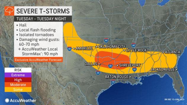
Continuing this week, forecasters warn that daily rounds of intense storms will remain in the cards.
• Have the app? Unlock AccuWeather Alerts™ with Premium+
"Within a swath from eastern Colorado to Mississippi and Alabama, severe weather will be possible on Tuesday," Thornton explained. Within this region, a corridor in Texas including cities such as Fort Worth and Abilene will be most at risk for intense storms.
Farther east, storms are expected to develop during the evening hours in Mississippi, Alabama and Georgia.
Storms during the early week will be able to unload hail, heavy rain, damaging wind gusts and even spin up an isolated tornado.
 |
"The western portions of this zone, in particular, could really use some downpours, namely Kansas and western Oklahoma, as drought conditions persist," Thornton added.
Kansas remains the state with the worst drought conditions across the country, according to the U.S. Drought Monitor. Ninety-one percent of the Sunflower State is experiencing conditions ranging from abnormally dry to exceptional drought.
For neighboring Oklahoma, almost all of the state's panhandle is under severe drought conditions.
 |
The prime risk for severe weather will slowly shift eastward by midweek as the pattern in the upper levels of the atmosphere undergoes a bit of a shake-up. This moderate risk zone will follow a day with more sporadic severe weather on Tuesday.
"By Wednesday, the corridor of thunderstorms may push its way toward the Southeast, rather than the Plains states," Thornton said. Cities such as Birmingham, Alabama, and Atlanta, Georgia, may be threatened by these storms.
 |
The positioning of storms on Wednesday will be highly dependent upon exactly where the previous day's storms develop. For this reason, while severe storms are also likely in portions of the Southeast on Thursday, there is still low confidence as to their exact location. Nevertheless, cities such as Jacksonville and Pensacola, Florida, may have to dodge intense storms later in the week.
 |
Looking ahead to the end of this week, AccuWeather forecasters will continue to monitor opportunities for damaging weather in portions of the southern U.S.
Want next-level safety, ad-free? Unlock advanced, hyperlocal severe weather alerts when you subscribe to Premium+ on the AccuWeather app. AccuWeather Alerts™ are prompted by our expert meteorologists who monitor and analyze dangerous weather risks 24/7 to keep you and your family safer.
