Namibia's Spring Floods Seen from Space (Photo)
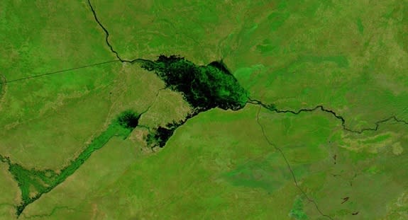
Floodwaters appear black against a background of brilliant green in new satellite imagery of Namibia's Zambezi and Chobe rivers.
The flooding satellite images come from NASA's Aqua satellite, and were snapped on May 13 by Aqua's Moderate Resolution Imaging Spectrometer (MODIS). The widespread flooding is typical for this time of year, according to NASA's Earth Observatory.
The Zambezi river is Africa's fourth-longest. It's most famous for the continent's iconic landmark, Victoria Falls, which is on the border of Zambia and Zimbabwe. With a height of 354 feet (108 meters) and a width of 5,604 feet (1,708 m), Victoria Falls, also known as Mosi-oa-Tunya, produces the world's largest face of falling water.
The Chobe arises in Angola and is known as the Cuando and the Linyanti at various points along its path. In this image, the Chobe is seen draining into the Zambezi.
Before the Zambezi was dammed in the 1960s, its large seasonal floods supported a huge delta and floodplain ecosystem. Floods still occur, as seen in this satellite image, but they are smaller and shorter in duration.
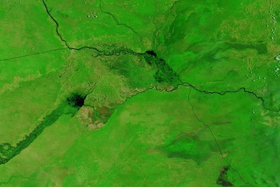
A comparison image taken on Feb. 21 shows the area before the flooding hit. The 2014 floods were minor in comparison to heavy flooding in 2004 and 2009. Nevertheless, a few villages were swamped and several schools inundated, according to news reports. No loss of life was reported.
Follow Stephanie Pappas on Twitter and Google+. Follow us @livescience, Facebook & Google+. Original article on Live Science.
Copyright 2014 LiveScience, a TechMediaNetwork company. All rights reserved. This material may not be published, broadcast, rewritten or redistributed.
