NASA releases first U.S. pollution map images from new space instrument
NASA has released the first data maps from a new instrument monitoring air pollution from space. The visualizations show high levels of major pollutants like nitrogen dioxide — a reactive chemical usually produced when fossil fuels are burned for transportation, power generation and other industrial activities, as well as wildfires — in the atmosphere over parts of North America.
Those images, which NASA compiled into a time lapse video and published on Thursday, pinpointed several urban areas in the United States, Canada, Mexico and the Caribbean as hotspots for air pollution, particularly during certain times of day. The pollution maps "show high levels of nitrogen dioxide over cities in the morning, and enhanced levels of nitrogen dioxide over major highways," the agency explained in a news release. Pollution dissipated in those areas in the early afternoon before ramping up again later as cities experienced "their second rush hour of the day."
The data used to create NASA's new air pollution maps was collected on August 2. High concentrations of nitrogen dioxide were detected over a number of U.S. cities and their surrounding regions, including Dallas, Houston, New Orleans, New York, Philadelphia and Washington, D.C.

Air pollution is being observed by a light analyzer called the Tropospheric Emissions: Monitoring of Pollution, or TEMPO, which was born out of a collaboration between the NASA Langley Research Center and the Smithsonnian Astrophysical Observatory. The instrument was launched into orbit by a SpaceX Falcon 9 rocket in April alongside a communications satellite, and it currently observes Earth from 22,000 miles above the equator, according to NASA.
The TEMPO spectrometer is the first "space-based instrument designed to continuously measure air quality over North America with the resolution of a few square miles," the agency said in a statement. It measures sunlight as it reflects off of the Earth's surface, clouds and the atmosphere, and helps determine the amount of gas present, since atmospheric gases absorb sunlight.
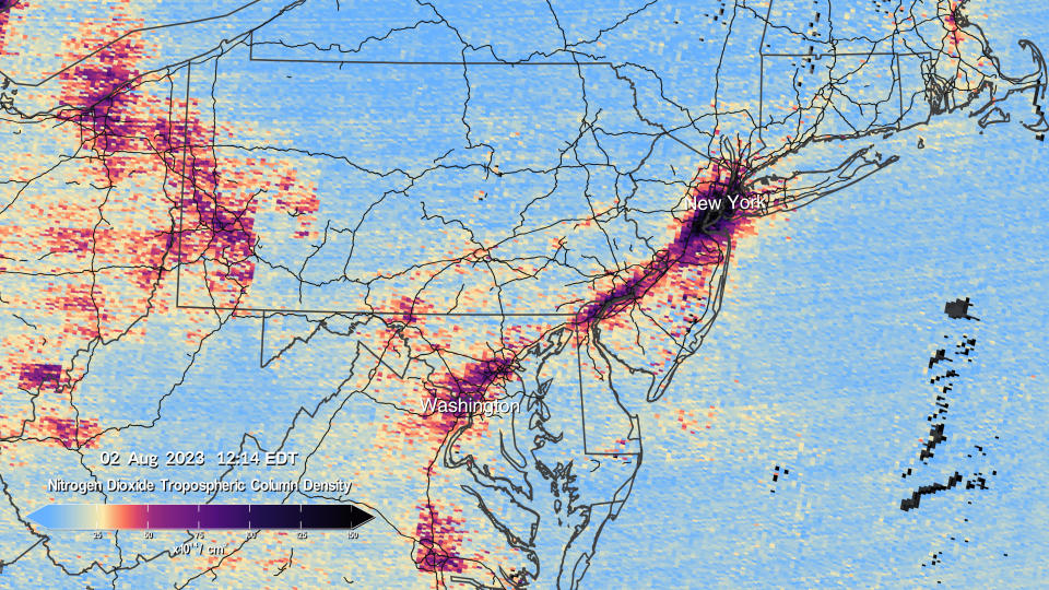
Nitrogen dioxide detected by TEMPO had to rise above the clouds in order for the spectrometer to take note of it, since the instrument uses visible sunlight to gather its data and make measurements. Cloudy areas are shown as missing data in NASA's visualizations, and TEMPO can only record air pollution during daylight hours.
After heat waves baked vast areas of the globe and massive Canadian wildfires depleted air quality for millions across the U.S. this summer, fueling concerns about the effects of climate change, experts are pointing to the value of TEMPO's comprehensive bank of air pollution data.
"Neighborhoods and communities across the country will benefit from TEMPO's game-changing data for decades to come," said NASA Administrator Bill Nelson in a statement. "This summer, millions of Americans felt firsthand the effect of smoke from forest fires on our health. NASA and the Biden-Harris Administration are committed to making it easier for everyday Americans and decisionmakers to access and use TEMPO data to monitor and improve the quality of the air we breathe, benefitting life here on Earth."
Spanish soccer federation asks Luis Rubiales to resign after unwanted kiss

