How NASA's Curiosity rover overcame its steepest Mars climb yet (video)

NASA's Curiosity rover marked its 11th year on Mars on Aug. 5, but the tireless spacecraft is still pushing itself to explore the Red Planet.
Curiosity is working its way up through the foothills of Mount Sharp, a 3-mile-tall (5 kilometers) mountain that was, billions of years ago, home to lakes and rivers.
The terrain is challenging, but the layering of the mountain provides unprecedented insights into different eras of Mars' past and how the planet's landscape changed over time.
Related: Curiosity rover: 15 awe-inspiring photos of Mars (gallery)
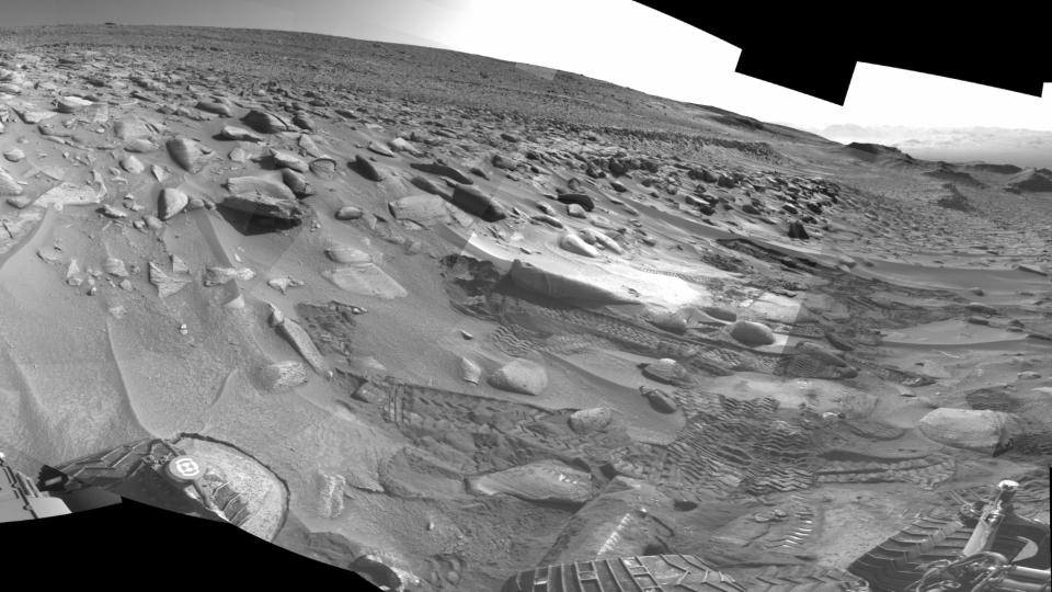
This quest recently provided Curiosity and its team of drivers, planners, engineers and scientists with its toughest climb yet: a sharp 23-degree slope covered slippery sand and wheel-size rocks.
"If you've ever tried running up a sand dune on a beach — and that's essentially what we were doing – you know it's hard, but there were boulders in there as well," said Amy Hale, a Curiosity rover driver at NASA's Jet Propulsion Laboratory (JPL) in Southern California, in a statement.
This combination of features saw the rover struggle to make progress. An attempt on June 1 resulted in Curiosity unexpectedly driving over a rock, resulting in a large movement of the suspension and triggering a safety fault, stopping the drive, NASA said.
Images from the rover's navigation cameras posted in June focus on a few of the rear wheels while the indefatigable Curiosity attempted its way up the slippery, rock-strewn incline.
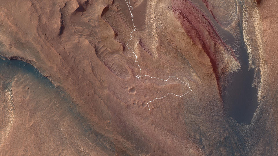
Further faulted drives, which can be triggered by wheels slipping too much or being raised by rocks, led to the decision to make a detour to less difficult terrain about 492 feet (150 meters) away.
The initial route for Curiosity was planned out using orbital images. While NASA's Mars Reconnaissance Orbiter can provide high-resolution images, it cannot reveal all the features and hazards hundreds of miles away on the surface below.
The rover's planners and drivers therefore use images from navigation and other cameras on the robot to calculate ways past and through hazards and refine Curiosity's path and protect the rover's damaged wheels.
RELATED STORIES:
— Life on Mars: Exploration and evidence
— NASA's Mars rover Curiosity sees dazzling 'sun rays' over Red Planet
— Curiosity rover on Mars gets a brain boost to think (and move) faster
The detour added a few weeks to the journey, but with no further surprises lurking in wait for Curiosity, the rover crested the slope, gaining access to an intriguing, crater-pocked location nicknamed "Jau."
"It felt great to finally get over the ridge and see that amazing vista," said Dane Schoelen, Curiosity's strategic route planning lead at JPL.
"I get to look at images of Mars all day long, so I really get a sense of the landscape," Schoelen added. "I often feel like I'm standing right there next to Curiosity, looking back at how far it has climbed."
Curiosity is now continuing its ascent of Mount Sharp to access new, higher areas for investigation.

