Nashville area should expect more rain, strong winds and even light snow tonight
Bundle up Nashville, it's about to be a windy, rainy and possibly snowy week.
The wind advisory that the National Weather Service issued for all of Middle Tennessee on Monday, has been extended into midnight on Tuesday they announced.
The NWS said widespread wind gusts of 35-45 mph can be expected with some areas experiencing winds of up to 50 mph Tuesday night.
The NWS advises that people should secure loose items in the yard and warned that winds can potentially break large branches and lead to power outages. High profile vehicles could also have issues they said, especially on West-East roadways.
Additionally, expected rainfall during that same timeframe will range from one to two inches for most of the Middle Tennessee region.
Simulated radar imagery for Middle Tennessee from noon today until midnight tomorrow night showing how rain is expected to develop and move across the mid state during the next 36 hours pic.twitter.com/RdDzQVNlDp
— NWS Nashville (@NWSNashville) January 8, 2024
Middle Tennessee will also see some snow this week, although in slight amounts and mainly among the Cumberland Plateau region. According to the NWS, the snow will likely fall between 8 p.m. Tuesday to 6 a.m. Wednesday.
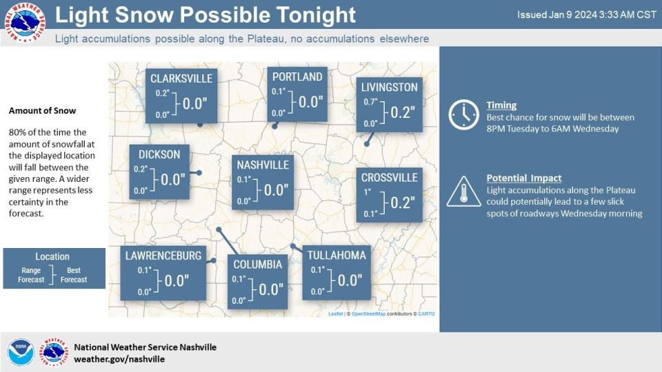
Music City will not see any snowfall, however surrounding areas will see less than an inch.
As temperatures drop to the 30s Tuesday night, rain showers are expected to change to snow showers across the Midstate.
According to the NWS, the storm system throughout the week will provide a better chance for wraparound snow showers area-wide with minor accumulation (less than 1 inch) possible Friday night.
"Little or no snow accumulation is expected for most areas, but a couple tenths of an inch of snow may impact the counties along the KY border and across the Upper Cumberland," said the NWS on Monday.
Nashville 7-day forecast
Tuesday: Temperature are expected to rise near 54 by 10 a.m., then drop to around 45 during the remainder of the day, showers before 11 a.m. Windy with winds reaching gusts as high as 45 mph. Chance of precipitation is 80%, new precipitation amounts between a tenth and quarter of an inch possible.
A chance of showers mixing with snow after 8 p.m. then gradually ending, chance of precipitation is 40%. Temperature will drop to 32. Winds could gust as high as 50 mph.
Wednesday: Mostly cloudy, then gradually becoming sunny, with a high near 46. Southwest wind 10 to 15 mph, with gusts as high as 20 mph.
Mostly clear with a low around 34 at night. South wind 10 to 15 mph, with gusts as high as 25 mph.
Thursday: Sunny with a high near 57, south southwest wind around 10 mph.
Showers likely mainly after midnight, chance of precipitation is 60%. Mostly cloudy, with a low around 43. Southeast wind 10 to 20 mph, with gusts as high as 30 mph.
Friday: Showers, with thunderstorms also possible after 9 a.m., chance of precipitation is 100%. High near 56. Windy, with a south southeast wind 20 to 30 mph becoming southwest in the afternoon. Winds could gust as high as 45 mph.
A chance of rain and snow showers before midnight then a slight chance of snow showers, chance of precipitation is 30%. Mostly cloudy, with a low around 26. Windy, with a west southwest wind 25 to 30 mph, with gusts as high as 45 mph.
Saturday: Partly sunny with a high near 38. Windy, with a west wind 15 to 25 mph, with gusts as high as 35 mph. Partly cloudy, with a low around 22 at night.
Sunday: A 20% chance of snow showers. Partly sunny, with a high near 40. A 50% chance of snow showers. Mostly cloudy, with a low around 19 at night.
Martin Luther King Jr. Day: A 50% chance of snow showers. Mostly cloudy, with a high near 29.
Nashville area weather radar
Diana Leyva covers trending news and service for The Tennessean. Contact her at Dleyva@gannett.com or follow her on X, the platform formerly known as Twitter at @_leyvadiana
This article originally appeared on Nashville Tennessean: Nashville weather: Gusty winds, snow showers expected for Middle TN

