Nashville Planning Commission reluctantly recommends new district maps for smaller council
Just after the Tennessee General Assembly expelled one of Nashville's state House representatives Thursday, the city's planning commission reluctantly approved two redistricting maps for a smaller Nashville Council — a decision with a short timeline recently imposed upon them by a new state law.
The law, passed in March by the state legislature's Republican supermajority at the opposition of Davidson County representatives, limits city and metropolitan councils to 20 members or fewer. It also requires Nashville's planning department and commission to present a new, compliant map to the current Metro Council by April 10 (within 30 days of the bill being signed into law).
Metro Nashville, which has had 40 council seats since its consolidation in 1962, is the only local government immediately impacted by the Council Reduction Act.
The commission recommended two maps: one with 15 districts and five at-large council seats, and one with 17 districts and three at-large seats, along with several changes based on public feedback on the second set of draft maps published Wednesday.
The current council can choose to accept or reject any map it receives. If the council does not approve a new map by May 1, current members' terms would be extended one year and council seats would be taken off the ballot for Nashville's local election on Aug. 3.
A pending lawsuit challenging the constitutionality of the new state law could change the timeline — a three-judge panel held a hearing Tuesday on Metro's request to halt the law's implementation until after Nashville's Aug. 3 local elections are complete. The panel is expected to make a ruling on an expedited timeline. If the panel does grant Metro an injunction, it's likely the Aug. 3 election will proceed as originally planned with 40 council seats on the ballot.
More information on the maps and the redistricting process can be found at www.redistrict.nashville.gov.
Ex-officio Planning Commissioner Mina Johnson said Thursday Nashville and Davidson County residents have made it "crystal clear" that they prefer the district maps with 35 council districts created in the 2021 redistricting process based on 2020 Census data.
"However, it's not an option. To meet the act and to meet our obligation, we have to recommend one of the maps," she said.
East Nashville Council member Brett Withers, who also sits on the Planning Commission, delivered an emotional address at Thursday's meeting.
"Our state has forced this upon the Planning Commission staff and upon our citizens, and just moments ago, our state disenfranchised half of District 6, and lots of other council districts, and that's just weighing on me so hard," Withers said.
Catch up: New draft district maps released for smaller Nashville Council
17 districts, 3 at-large seats
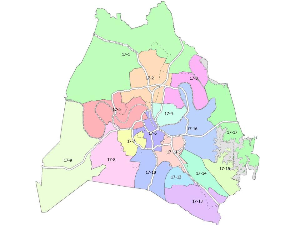
Recommended amendments include:
In response to concerns over a Saunders Lane boundary splitting two neighborhoods between districts 17-2 and 17-3, this amendment shifts that boundary to Graycroft north of Due West and to the railroad south of Due West. This allows both districts to continue to comply with the equal population standards.
The Haywood neighborhood is partially split between District 17-11 and District 17-12. Planners were not able to include the full neighborhood in one district due to population balance requirements, but did adjust boundaries to the west, creating a more equal split.
Moving the boundary from the railroad to I-24 would keep Mill Ridge Park in one district.
15 districts, 5 at-large seats
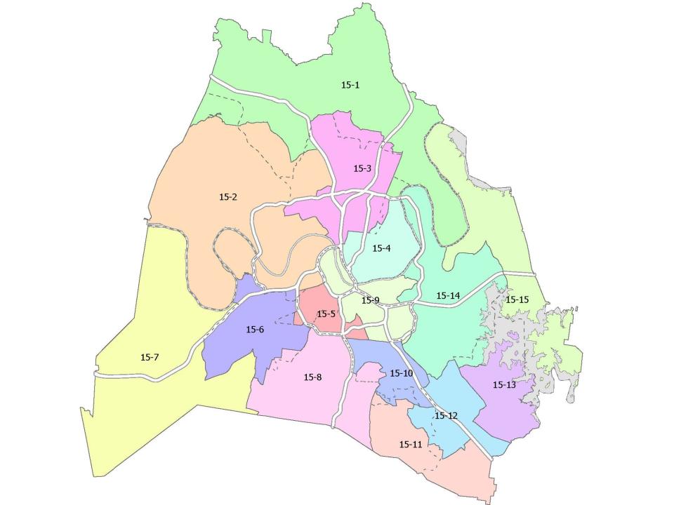
Recommended amendments include:
Moving the boundary of district 15-2 to I-24 and Briley to address the split of Brick Church Lane between districts 15-2 and 15-3, still in keeping with population balance requirements.
Including Lebanon Pike neighborhoods with Donelson/Hermitage in District 15-14.
Shifting the southern boundary for District 15-14 north to Murfreesboro Pike.
Incorporating the Rosedale and nearby neighborhoods into District 15-9 with other South Nashville neighborhoods.
Eliminating a split neighborhood in Green Hills, fully incorporating it into District 15-6.
Restoring Wentworth-Caldwell Park to the Crieve Hall district (15-8).
Shifting Whitworth along West End into District 15-5.
Reconfiguring neighborhoods along Whispering Hills and Tusculum Road to keep neighborhoods together and strengthen the Hispanic plurality district of 15-10
This article originally appeared on Nashville Tennessean: Nashville Planning Commission reluctantly approves maps for smaller council

