Nashville weather: Davidson County under severe thunderstorm warning
Strong to severe thunderstorm are possible Wednesday with damaging straight line wind posing the biggest threat, though a tornado is possible, according to National Weather Service in Nashville.
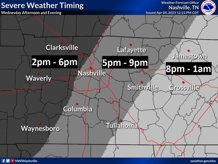
Storms are expected to roll into Middle Tennessee around 2 p.m. and hit the Cumberland plateau by 1 a.m. Thursday with sustained, straight-line winds up to 35 mph and gusts up to 60 mph. The Nashville Metro area will likely see rain starting around 5 p.m.
At 3:51 p.m., a severe thunderstorm warning was issued for Davidson County with wind gusts of 60 mph and one or larger diameter sized hail possible.
A severe thunderstorm watch was issued shortly before 2 p.m. until 9 p.m. that includes Benton, Bedford, Cannon, Chester, Clay, Coffee, Decatur, De Kalb, Giles, Hardeman, Hardin, Henderson, Jackson, Lincoln, Macon, Marshall, McNairy, Moore, Overton, Pickett, Putnam, Rutherford, Smith, Stewart, Trousdale and Wilson counties.
The western portion of the region, including Clarksville, Nashville, Williamson County and Columbia, are under an enhanced risk (level 3 of 5) for severe storms. The rest of the region is under a slight risk (level 2 of 5).
Heavy rainfall and flash flooding potential is possible for areas west of I-65 and north of I-40, according to forecasts.
Davidson County and much of Middle Tennessee is under a flood watch until 1 a.m., according to NWS.
Here's the latest idea on timing for severe potential Wednesday. While the main hazards will be damaging straight line winds and large hail, a tornado or two cannot be ruled out. Stay weather aware tomorrow! pic.twitter.com/MFsWjFwgmX
— NWS Nashville (@NWSNashville) April 5, 2023
Risk levels are similar to last Friday's storms which produced several strong tornadoes, killed about a dozen people in west Tennessee and destroyed over 75 homes. There are some differences between the forecasts, NWS said.
A tornado watch or a warning? A tornado watch or a warning? Here's the difference between the two and what to do during severe weather
"Today's environment is marked by greater instability and less wind shear. This translates to a greater hail threat but a lower tornado threat," NWS said Wednesday morning. "Also, this is a slower-moving system than Friday night's cold front, so rainfall amounts look to be greater and so the risk of localized flooding is also greater."
Early dismissals at school
Some schools have announced early dismissals ahead of severe weather Today.
Here's the schools dismissing early:
Cheatham County Schools: Closing at 1 p.m.
Dickson County Schools: Closing at 1 p.m.
Houston County Schools: Closing at 1 p.m.
Humphreys County Schools: Closing at 1 p.m.
Robertson County Schools: Closing two hours early, all after school events cancelled
Due to severe weather concerns, Robertson County Schools will close 2 hours earlier than normal dismissal time on Wednesday, April 5th, 2023. All afterschool events are cancelled. pic.twitter.com/zOa2ANZih1
— Robertson County Schools (@RobCoSchools) April 5, 2023
Nashville-area weather radar
Nashville forecast
Wednesday: Chance of showers and possible thunderstorms, high around 80. Showers and thunderstorms possible in the evening, low around 49.
Thursday: Chance of showers, mostly cloudy with a high near 59 and lows around 46.
Friday: Partly sunny with a high near 62. Chance of showers overnight with lows around 48.
Saturday: Partly sunny with a high near 66. Chance of showers in the evening with a low around 50.
Sunday: Mostly sunny with a high near 70, low around 48.
Monday: Sunny with a high near 73, low around 50.
Reach reporter Craig Shoup by email at cshoup@gannett.com and on Twitter @Craig_Shoup. To support his work, sign up for a digital subscription to www.tennessean.com.
This article originally appeared on Nashville Tennessean: Nashville severe weather: Thunderstorm watch issued in Middle Tennessee

