More rain but no severe weather for Nashville as storms sweep US
As winter storms delay flights and close highways in the West, the South is bracing for the risk of severe storms later this week.
The severe risk will likely miss Middle Tennessee, according to the National Weather Service in Nashville. However, after a brief break, rain will return to the region Tuesday evening into Wednesday.
"An isolated thunderstorm is possible, but severe weather is not expected," the NWS Nashville forecast said. "Heavy rain is possible, especially Wednesday morning."
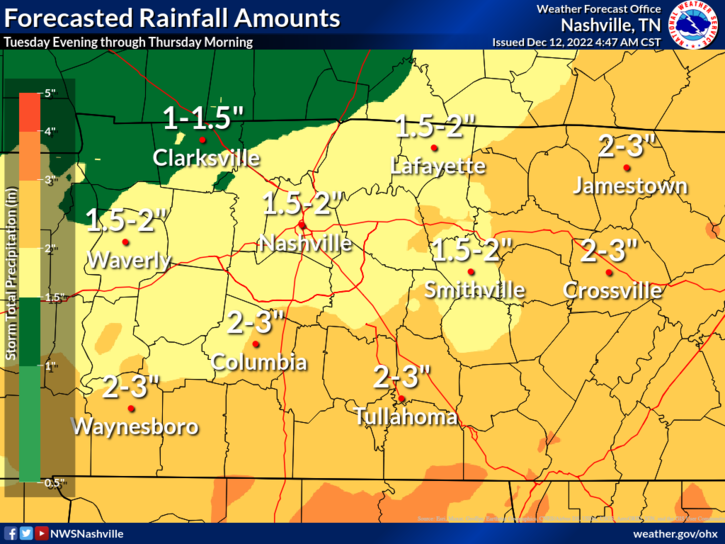
Rain totals between 1-3 inches are possible, with 3+ inches possible in some isolated locations. There are no concerns for major flooding, NWS Nashville said.
The Nashville area is expected to get 1.5-2 inches of rain from Tuesday evening through Thursday morning. Between 1-1.5 inches are forecast for Clarksville and 2-3 inches are possible in Columbia and parts of Williamson County.
Highs are expected in the mid 50s to lower 60s most of the week across Middle Tennessee, with lows fluctuating between the upper 30s and low 50s. Temperatures will dip starting Friday and into the weekend.
"Reaching the top of the rollercoaster soon, with a rapid fall coming to end the week," NWS Nashville tweeted Monday. "For those waiting for the colder temps, they're coming! For those loving the warmer temps, we've got bad news for you."
🎢 Reaching the top of the rollercoaster soon, with a rapid fall coming to end the week!
For those waiting for the colder temps, they're coming! For those loving the warmer temps, we've got bad news for you... pic.twitter.com/dkDdEWCelh— NWS Nashville (@NWSNashville) December 12, 2022
Thunderstorms across South could bring tornadoes, hail
While Tennessee as a whole will mostly see rain and a few rolls of thunder, other parts of the South are at risk for severe thunderstorms, tornadoes, strong wind gusts and hail this week, the forecast shows.
National outlook:'Whiteout conditions': Winter storm could fuel blizzard conditions, travel havoc across swath of US
Severe weather is possible across the Southern Plains, extending southeast into Mississippi, Alabama, Louisiana and Florida from roughly Monday through Thursday, according to the Storm Prediction Center.
"The drastic contrast of the warm, humid air ahead of the storm and the cold, dry air following the storm will create the right atmospheric conditions for an eruption of severe weather," AccuWeather meteorologist Renee Duff said.
Nashville-area radar
Nashville forecast
Monday: Mostly cloudy. High: 54; low: 39.
Tuesday: 20% chance of showers after 4 p.m. and an 80% chance of precipitation overnight, with showers and a possible thunderstorm after midnight. High: 60; low: 50.
Wednesday: Chance of showers and thunderstorms throughout the day and into the overnight hours. Chance of precipitation is 90%, dropping to 70% overnight into Thursday morning. High: 59; low: 42.
Thursday: Sunny. High: 53; low: 33.
Friday: Mostly sunny. High 45; low: 29.
USA Today contributed to this story.
This article originally appeared on Nashville Tennessean: Nashville weather: No severe risk in Middle TN as storms sweep US

