Nashville weather: More rain, strong winds and hail possible
Nashville and Middle Tennessee could see some strong winds and hail this afternoon as more rain moves into the area.
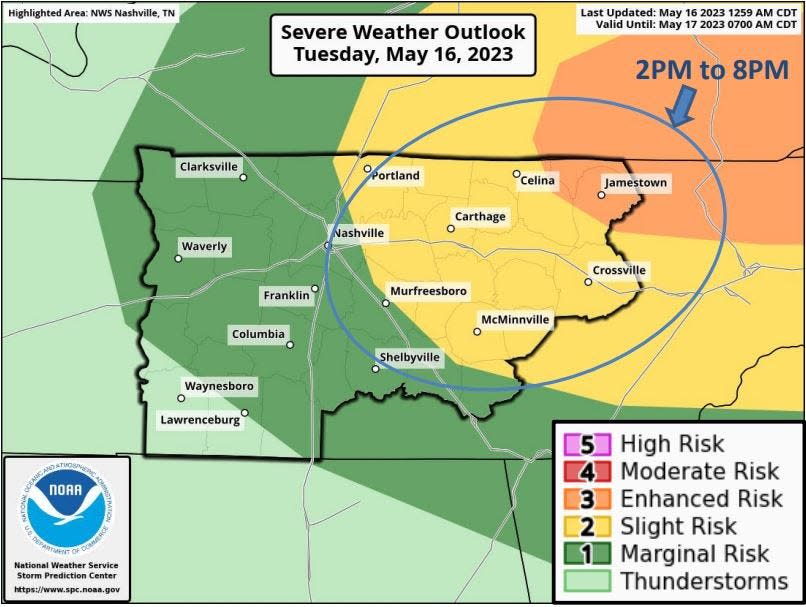
A broken line of storms will hit the region between 2 p.m. and 8 p.m. Tuesday, according to the National Weather Service.
The greatest risk is east of Nashville with areas as far as Crossville at a slight risk (2 of 5). Areas around Jamestown are at an enhanced risk (3 of 5). Nashville is on the lowest risk for the weather event.
"Storms will be developing just ahead of a cold front and may not move through In the form of a broad broken line of storms," according to the NWS. "Instability isn't impressive, but the front should help to organize storms enough to produce strong to damaging winds in some areas."
The NWS issued a severe thunderstorm watch for areas east of Interstte 65 and north of Interstate 40 until 7 p.m.
"Tornado chances are low, but whether wind is blowing in a circle or a straight line at 65 mph, it can still drop trees and be dangerous," the NWS tweeted.
Ok, the watch is out.
Yes, it's a #Severe Thunderstorm Watch, but don't just throw it aside. Tornado chances are low, but whether wind is blowing in a circle or in a straight line at 65 mph, it can still drop trees and be dangerous.
Have multiple ways to get warnings! #tnwx pic.twitter.com/UrM8Ab1noT— NWS Nashville (@NWSNashville) May 16, 2023
Nashville-area weather radar
Nashville forecast
Tuesday: Showers and thunderstorms after 4 p.m. with a high near 87 and low near 59.
Wednesday: Sunny, with a high near 81 and low around 57.
Thursday: 30% chance of showers and thunderstorms after 1 p.m. with a high near 82 and low around 61.
Friday: 30% chance of showers and thunderstoms after 1 p.m. with a high near 80 and low around 61.
Saturday: 50% chance of showers, partly sunny with a high near 76 and low around 55.
Sunday: 20% chance of showers, mostly sunny with a high near 78 and low around 57.
This article originally appeared on Nashville Tennessean: Nashville weather: Thunderstorms, strong winds and hail possible

