Nashville weather: Ground stop at Nashville International Airport lifted
Severe weather rolled into Nashville during the afternoon with the threat of flooding in Middle Tennessee overnight.
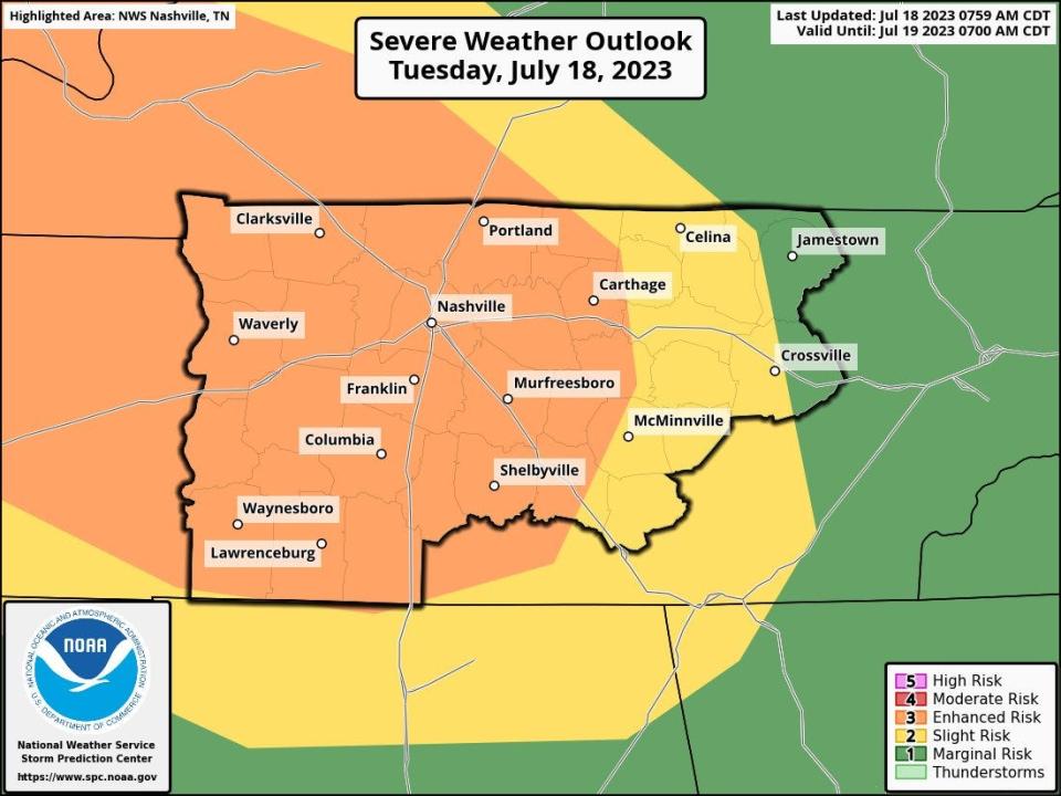
The National Weather Service said two rounds of hazardous weather will be possible Tuesday. Nashville, north to Portland, south to the state line, east to Carthage and the western counties in Middle Tennessee are all listed under an enhanced risk (3 of 5) for severe storms while the majority of eastern Middle Tennessee is under a slight risk (2 of 5).
A ground stop for arriving flights at Nashville International Airport was lifted at 5:30 p.m.
Due to weather, Ascend Amphitheater delayed opening its gates until 7 p.m. prior to the 7:30 p.m. Louis Tomlinson: Faith in The Future World Tour 2023.
https://twitter.com/Ascend_amp/status/1681437933851516928
A severe thunderstorm warning was issued for Benton, Carroll, Decatur and Henry Counties until 3:30 p.m., according to NWS Nashville, with winds reaching 70 mph.
Nashville and much of Middle Tennessee is under a severe thunderstorm watch until 8 p.m., according to the NWS. Counties included in the watch area include: Cheatham; Clay; Coffee; Cumberland; Davidson; De Kalb; Dickson; Fentress; Grundy; Hickman; Houston; Humphreys; Jackson; Lewis; Maury; Montgomery; Overton; Perry; Pickett; Putnam; Robertson; Stewart; Sumner; Van Buren; Warren; White; Williamson and Wilson.
"There is increasing concern that flooding will occur somehwere in Middle Tennessee by early tomorrow morning," the NWS wrote in their morning report. "The greatest threat is for the northwester portions of our area, but this could change!"
The first wave of weather will likely come between 1 p.m. and 7 p.m. with the focus area west of Interstate 65 a well as along and north of Interstate 40. Damaging winds will be the main concern, NWS said.
Multiple rounds of heavy rainfall could lead to flash flooding overnight in Middle Tennessee but particularly those west of I-65, NWS said.
Nashville-area weather radar
Nashville weather forecast
Tuesday: Chance of severe weather mainly after noon with a high near 91 and heat index close to 100. Overnight rain chances threaten flooding in Middle Tennessee. Lows around 72.
Wednesday: Showers and thunderstorms likely, mainly before 7 a.m. Partly sunny with a high near 93 and heat index as high as 106 in the afternoon. A 40% chance of showers and thunderstorms overnight with a low around 75.
Thursday: A 50% chance of showers and thunderstorms during the day and evening with a high near 93 and low around 73.
Friday: A 50% chance of showers and thunderstorms during the day with a high near 87 and low around 66.
Saturday: A slight chance of showers with thunderstorms possible after 1 p.m. otherwise sunny with a high near 84 and low around 63.
Sunday: Sunny with a high near 87 and a low around 65.
This article originally appeared on Nashville Tennessean: Nashville weather: Ground stop for arriving flights lifted

