National Hurricane Center: Potential cyclone forms, will bring heavy rain to southeast U.S.
Potential tropical cyclone Sixteen has formed from a large area of disorganized showers and thunderstorms off the east coast of the United States, according to the National Hurricane Center, with maximum sustained winds of 35 mph. It's expected to bring tropical-storm conditions to portions of the southeast and mid-Atlantic coast.
A tropical storm warning has been issued from Cape Fear, North Carolina, northward to Fenwick Island, Delaware, including Albemarle and Pamlico Sounds, and the Chesapeake Bay south of Smith Point. A storm surge watch has been issued from Surf City, North Carolina to Chincoteague, Virginia, and the for the Chesapeake Bay south of Smith Point, including Albemarle and Pamlico Sounds.
Rainfall is expected along the northeast Florida coast through the evening. The National Weather Service has issued a rip current statement from north Florida down to the southern Brevard barrier islands warning beachgoers that life-threatening rip currents may be present through late Friday night.
Gusts of 30-45 mph are possible, along with breakers of 5 to 8 feet. Residents could see hazardous seas, tidal flooding, deadly rip currents and beach erosion.
Meanwhile, Hurricane Nigel is taking off. The Category 1 hurricane, which weakened overnight to maximum sustained winds of 85 mph, is currently moving northeast at 30 mph. Nigel is expected to continue weakening over the next couple of days, forecasters said.
Looking ahead, the tropical wave off the coast of Africa near the Cabo Verde Islands is expected to merge with another disturbance a few hundred miles west of it in the next few days and likely become a tropical disturbance late this week or over the weekend as it starts to head this way.
We're now past the traditional peak of hurricane season, but WeatherTiger warns there is no short-term reprieve from the record streak of ten named storms roiling the Atlantic since August 20.
The next two names for tropical storms are Opehlia and Phillippe.
Here's the latest update from the NHC as of 2 p.m.:
Track Tropical Potential Cyclone 16

Special note on the NHC cone: The forecast track shows the most likely path of the center of the storm. It does not illustrate the full width of the storm or its impacts, and the center of the storm is likely to travel outside the cone up to 33% of the time.
Location: 355 miles southeast of Charleston, South Carolina
Maximum wind speed: 35 mph
Direction: north at 9 mph
At 2:00 p.m. EST, the disturbance was centered near latitude 28.7 North, longitude 75.9 West. The system is movingtoward the north near 9 mph, and this general motion is expected to continue through early Friday.
A north-northwestward to northward motion is forecast by late Friday and continue into the weekend. On the forecast track, the center of the cyclone is expected to approach the coast of North Carolina within the warning area Friday night and early Saturday.
Maximum sustained winds are near 35 mph with higher gusts. Strengthening is expected during the next day or two, and the system is forecast to become a tropical storm as it approaches the coast of North Carolina. Regardless of whether the system become a tropical storm, the system is expected to bring tropical-storm conditions to portions of the southeast and mid-Atlantic coast.
Formation chance through 48 hours: medium, 60 percent.
Formation chance through 7 days: medium, 60 percent.
Tropical storm conditions are expected to affect North Carolina, but mich of Fliorida;' east coast may see showers this evening and swells generated by this system will be affecting much of the east coast of the United States through this weekend.
Track Hurricane Nigel

Location: 505 miles southeast of Cape Race, Newfoundland
Maximum wind speed: 85 mph
Direction: northeast at 30 mph
➤ Spaghetti models for Hurricane Nigel:
At 11:00 a.m. EST, the center of Hurricane Nigel was located near latitude 42.2 North, longitude 45.0 West. Nigel is moving toward the northeast near 30 mph and this motion is expected to continue the next day or two.
Maximum sustained winds are near 85 mph with higher gusts. Weakening is forecast during the next couple of days, and Nigel is forecast to become a post-tropical cyclone by Friday.
Hurricane-force winds extend outward up to 60 miles from the center and tropical-storm-force winds extend outward up to 150 miles.
The estimated minimum central pressure is 977 mb.
Spaghetti models for Hurricane Nigel
Special note about spaghetti models: Illustrations include an array of forecast tools and models, and not all are created equal. The hurricane center uses only the top four or five highest-performing models to help make its forecasts.
What else is out there and how likely are they to strengthen?

A tropical wave located just west of the Cabo Verde Islands is producing some disorganized shower and thunderstorm activity.
Environmental conditions are forecast to be conducive for gradual development of this system, and a tropical depression is likely to form this weekend or early next week while the system moves generally westward at 10 to 15 mph across the eastern and central tropical Atlantic.
Formation chance through 48 hours: low, 20 percent.
Formation chance through seven days: high, 70 percent.
Who is likely to be impacted?
Potential Tropical Cyclone Sixteen: Tropical storm conditions are expected to affect North Carolina, but mich of Fliorida;' east coast may see showers this evening and swells generated by this system will be affecting much of the east coast of the United States through this weekend.
Hurricane Nigel: Swells generated by Nigel will affect Bermuda during the next couple of days. These swells are likely to cause life-threatening surf and rip current conditions.
NHC is now giving a low pressure area off the FL east coast a moderate chance to develop into a tropical or subtropical system in a few days. Expect low impacts overall, but coastal areas will see an increase in the wind & rain Friday. Dangerous surf & rip currents likely too. pic.twitter.com/eTEGG2JKqb
— Florida Storms (@FloridaStorms) September 20, 2023
It's too early at this time to determine if there will be any impact to the U.S. from the tropical wave.
Forecasters urge all residents to continue monitoring the tropics and to always be prepared.
Weather watches and warnings issued in Florida
When is the Atlantic hurricane season?
The Atlantic hurricane season runs from June 1 through Nov. 30.
When is the peak of hurricane season?
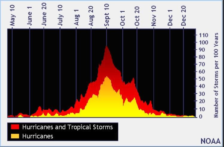
The peak of the season is Sept. 10, with the most activity happening between mid-August and mid-October, according to the Hurricane Center.
Tropical forecast over the next seven days
Excessive rainfall forecast
What's out there?
Systems currently being monitored by the National Hurricane Center.

Noaa
Embedded content: https://www.nhc.noaa.gov/xgtwo/two_atl_0d0.png?052051
What's next?
We will continue to update our tropical weather coverage daily. Download your local site's app to ensure you're always connected to the news. And look at our special subscription offers here.
This article originally appeared on The Daytona Beach News-Journal: National Hurricane Center: NHC tracking three systems in Atlantic

