National Hurricane Center experimenting with new cone this season. Here's what we know
The National Hurricane Center will bring out an experimental tropical cyclone forecast cone graphic just in time for the busiest months of the 2024 Atlantic hurricane season.
The new cone will add tropical storm and hurricane watches and warnings for interior counties in the path of the storm. The current cone displays watches and warnings only for coastal counties.
Watches and warnings for interior counties has been provided by local National Weather Service offices. The new graphic will combine tropical storm and hurricane watches and warnings into a single graphic.
The Atlantic hurricane season runs from June 1 through Nov. 30., and the most active period runs from August through October. The peak of the season is Sept. 10.
What's different with the National Hurricane Center's 'cone of uncertainty'?
The new experimental cone will reflect watches and warnings issued for interior counties, not just those on the coast.
Previous NHC cones showed the projected path of a tropical storm or hurricane, as well as the timing of the storm and any watches and warnings, only for coastal areas.
The new graphic will continue to have the same information but also illustrate potential impacts for areas away from the coast.
The new cone will place an emphasis on tropical storm and hurricane watches and warnings for both coastal and inland counties.
The watches and warnings will take precedence over the cone, the National Hurricane Center said.
Why is changing the NHC cone important?
With the previous emphasis on watches and warnings issued along Florida's coasts, many inland residents and visitors remain unaware of the wind dangers an approaching storm could have well away from the coast.
“This change will give us a more complete depiction of the wind risk,” NHC Deputy Director Jamie Rhome said.
The NHC said research has suggested that the addition of inland watches and warnings to the cone graphic "will help communicate inland wind risk during tropical cyclone events while not overcomplicating the current version of the graphic with too many data layers.
"The impetus was to better depict the full scope of the wind hazard over inland areas. This is most critical for strong hurricanes that can carry tropical storm and hurricane force winds well inland, but it will improve the risk communication for wind hazards for all tropical cyclones," the Hurricane Center said.
De-emphasizing the NHC cone
The National Hurricane Center is also hoping to de-emphasize the cone most people tend to focus on and instead make warnings and watches stand out.
“As you look at the graphic, your eyes naturally gravitate to what is ultimately more important, which is the risk that comes with the storm,” Rhome said.
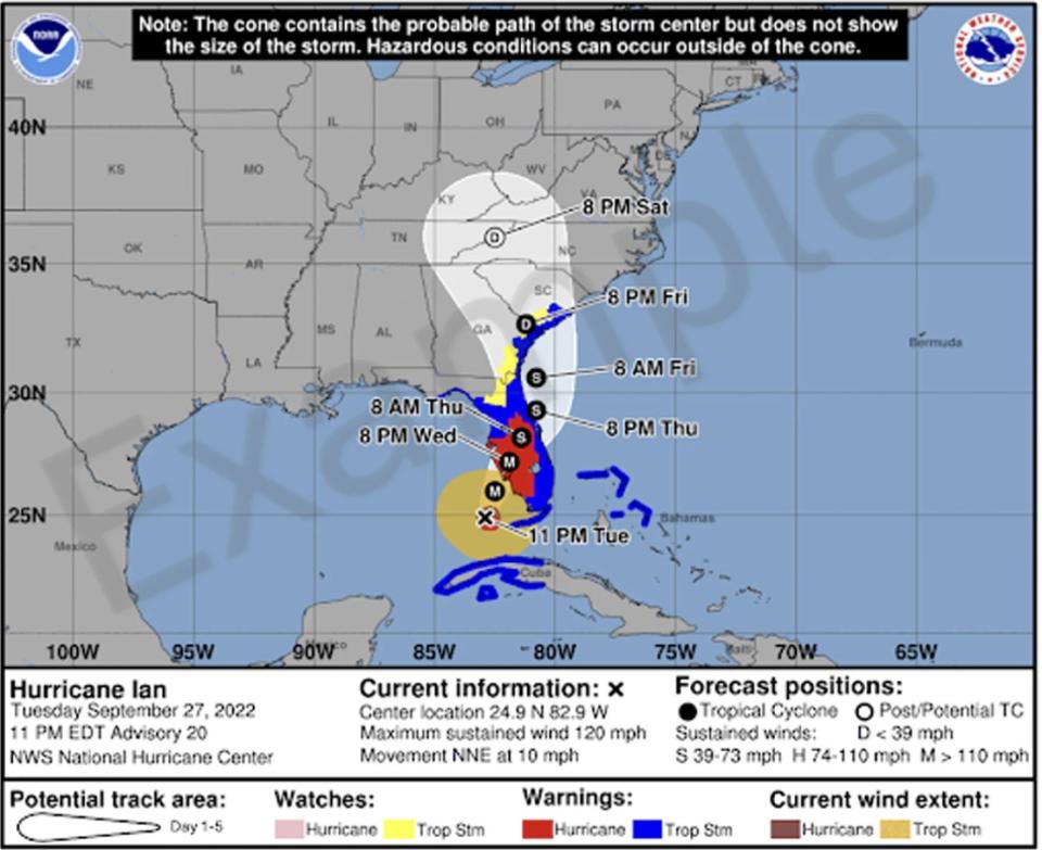
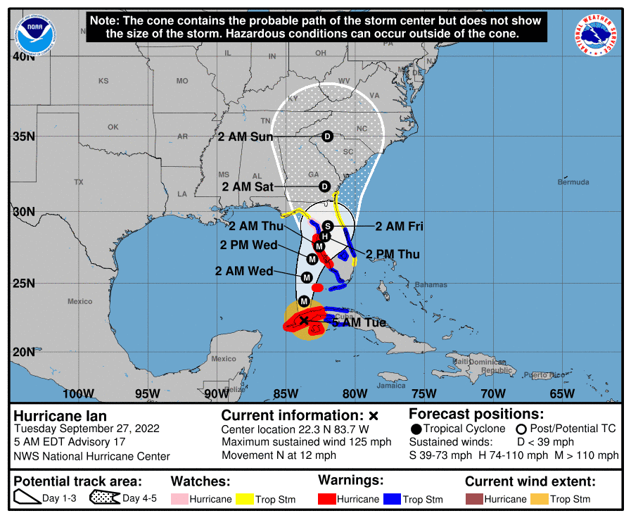
Compare Hurricane Ian's 2022 cone with the experimental cone
Hurricane Ian posed dangers across almost the entire state, not just Southwest Florida's coastal counties, but the original cone released as Hurricane Ian approached Florida only showed watches and warnings along the coast.
The experimental cone shows hurricane warnings for Ian well into Central Florida and tropical storm warnings along the entire East Coast and North Florida even as the storm moved across the state.
Hurricane, tropical storm watches and warnings to stay same colors
Watches will continue to be displayed in pink for hurricanes and yellow for tropical storms.
Warnings will continue to be displayed in red for hurricanes and blue for tropical storms.
In addition, the experimental version of the cone will use white transparent shading for the entire five-day forecast, instead of using white stippling for the four-to-five-day portion of the forecast as it is in the current version. The entire outline of the cone will be in white.
When will the National Hurricane Center start using the new cone?
2/1 at 9am: The National Hurricane Center (@NHC_Atlantic) will be implementing a new experimental cone graphic beginning on or around August 15th 2024.
This experimental graphic will help better convey wind hazard risk inland in addition to coastal wind hazards. pic.twitter.com/pDkNiRoupx— NWS Miami (@NWSMiami) February 1, 2024
The change will be put into practice on or around Aug. 15.
The experimental version will appear alongside the traditional graphic as meteorologists determine its usability for the public, according to the Florida Public Radio Emergency Network.
The new cone may not be posted online as quickly as the existing graphic since it takes time to compile inland watches and warnings, the NHC said. It should generally be available within 30 minutes of each advisory release.
Public comments to be gathered on experimental hurricane cone
“We bring new features or new additions and open these new features up for people to provide comments to us,” Rhome said.
“At the conclusion of the experiment, we use those comments to determine whether to make the change permanent, to discontinue the change or to evolve the change but in a different iteration.”
Reaction on X and Facebook to new cone mixed so far
The National Weather Service Miami announced on X, formerly known as Twitter, the Hurricane Center would be experimenting with the new cone.
Reactions ranged from one user saying the new cone "is more confusing than the normal cone" to "As long as they get rid of the center line that ran through the middle of the cone, I'll be happy."
Another user commented: "This should convey well and be realistic for people in the path."
Reactions to the Hurricane Center's announcement on its Facebook page were also mixed, although most people were positive about the change.
Comments ranged from "Very useful. Plenty of people are affected by hurricanes and they don’t live directly on the coast. They want to know what they can expect, even well inland."
Another was more precise: "Love, love this change."
"Makes it harder to see the track whether you're coastal or inland, in my humble opinion," one person wrote, while another said. "I like the extra info but it's a little more complicated."
Cone of uncertainty has been confusing to many
Ever since the National Hurricane Center started issuing the cone graphic in 2002, forecasters have found it often has been misunderstood and used in ways it wasn't meant to.
The cone is intended to depict where the center of the storm could go. So a cone that stretches from Sarasota to Naples means the center of a hurricane could come ashore in Sarasota, or the eye of the hurricane could make landfall in Naples.
And to emphasize: that's the center of the storm. Hurricanes can be hundreds of miles wide.
The cone is created by enclosing the area swept out by a set of circles — which aren't shown — along the forecast track every 12 hours for the first three days and then at 24 hours for days four and five. The size of each circle is set so that two-thirds of historical official forecast errors over a five-year sample fall within the circle.
In other words, the center of the storm stays within the cone for roughly two out of every three forecasts, the National Hurricane Center said.
The cone does not depict the size of the storm or the areas that could experience high winds, intense rainfall, or storm surge.
Confusion rose over cone as Hurricane Ian approached Florida
In September 2022, as Hurricane Ian approached Florida, the cone showed only watches and warnings at the coast. But while the Category 4 hurricane made landfall on the southwest coast, it left a path of destruction across Central Florida as it moved toward the Atlantic.
Both public officials and private citizens misinterpreted the graphic.
Barrier islands on the Southwest Florida coast in Lee County were always in or at the edge of the forecast cone, but residents and officials failed to comprehend that point, delaying critical decisions, experts said at the time.
Hurricane Ian: Were forecasts for Hurricane Ian wrong? What experts say about the 'cone of uncertainty.'
NHC cone has several other names
The National Hurricane Center's cone is known by several names, including the "cone of concern," the "cone of death" and the "cone of uncertainty."
Names for 2024 Atlantic hurricane season
Names for the 2024 Atlantic hurricane season are:
Alberto
Beryl
Chris
Debby
Ernesto
Francine
Gordon
Helene
Isaac
Joyce
Kirk
Leslie
Milton
Nadine
Oscar
Patty
Rafael
Sara
Tony
Valerie
William
Contributor: Dinah Voyles Pulver, USA TODAY.
This article originally appeared on Treasure Coast Newspapers: NHC experimental cone of uncertainty debuts in August. Changes to note

