National Hurricane Center tracking 3 disturbances. Two could become tropical depressions
The National Hurricane Center is tracking three disturbances, including one in the Gulf of Mexico, according to the latest advisory.
Forecasters said a broad area of low pressure could form in the central or western Gulf of Mexico by the beginning of next week. Some development is possible as it moves west.
The newest addition to the Hurricane Center's tropical outlook map joins two other tropical disturbances forecasters have been tracking since Sunday night.
Chances for development on both have increased. The National Hurricane Center said both could become a a tropical depressions over the coming days or over the weekend as they move west across the Atlantic.
The next named storm of the season will be Emily.
Tropics waking up: We've seen 278 days since a hurricane hit. But the tropics are waking up
The busiest period of the hurricane season is here. On average, more storms develop from August through October, with Sept. 10 being the peak of the season.
Last week, the National Oceanic and Atmospheric Administration updated its forecast for the 2023 Atlantic hurricane season, predicting "above-normal level of activity."
NOAA is predicting 14-21 named storms to develop this year, of which six to 11 could become hurricanes with two to five of those that could become major hurricanes. A major hurricane is one that has maximum sustained winds of at least 111 mph.
Here's the latest update from the NHC as of 2 p.m.:
What's out there and where are they?

Disturbance 1: Disorganized showers and thunderstorms located over the central tropical Atlantic are associated with an elongated trough of low pressure centered about 750 miles west-southwest of the Cabo Verde Islands.
Disturbance 2: A tropical wave near the Cabo Verde Islands is producing a large area of disorganized showers and thunderstorms.
Disturbance 3: A broad area of low pressure could form in the central or western Gulf of Mexico by the beginning of next week.
Tropical wave 1: A tropical wave in the eastern Caribbean is located east of Puerto Rico. It's moving west at 17 to 23 mph. Exact location: near 63W, from 18N southward.
Tropical wave 2: Another tropical wave is moving across Central America from the Gulf of Honduras southward into the east Pacific. It's moving west at 17 to 23 mph.
How likely are they to strengthen?
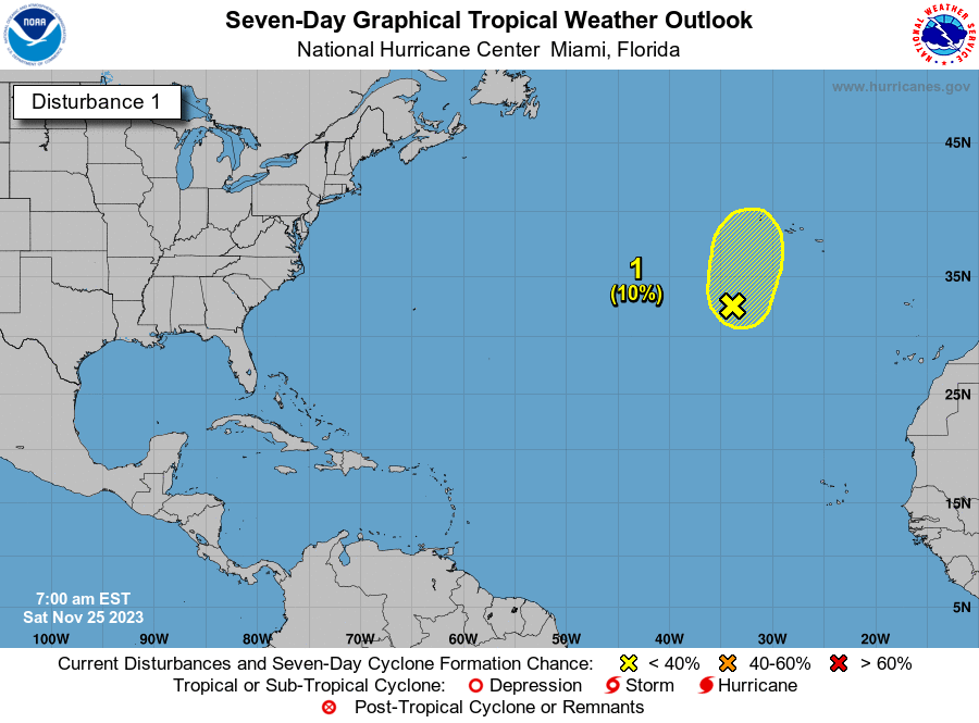
Disturbance 1: Environmental conditions appear conducive for gradual development of this system, and a tropical depression could form during the next several days while moving toward the west or west-northwest at about 10 mph across the central tropical Atlantic.
Formation chance through 48 hours: low, 30 percent.
Formation chance through seven days: medium, 50 percent.

Disturbance 2: This system is forecast to move toward the west-northwest at about 15 mph, with anarea of low pressure expected to form in a day or so just to the west of the Cabo Verde Islands.
Further development of the low is possible, and a tropical depression could form over the weekend before environmental conditions become unfavorable early next week.
Formation chance through 48 hours: low, 30 percent.
Formation chance through seven days: medium, 40 percent.

Disturbance 3: Some slow development of this system is possible thereafter as it moves westward andapproaches the western Gulf of Mexico coastline by the middle of next week.
Formation chance through 48 hours: low, near 0 percent.
Formation chance through seven days: low, 20 percent.
Who is likely to be impacted?
Disturbance 3: "It would not be out of the question for a tropical depression or storm to brew over the western and northern part of the Gulf and towards Texas or northern Mexico with heavy rain next week," said AccuWeather Senior Meteorologist Adam Douty.
It's too early at this time to determine if there will be any impact to the U.S. from the other two disturbances in the Atlantic or the tropical waves.
Forecasters urge all residents to continue monitoring the tropics and to always be prepared.
Weather watches and warnings issued in Florida
When is the Atlantic hurricane season?
The Atlantic hurricane season runs from June 1 through Nov. 30.
When is the peak of hurricane season?
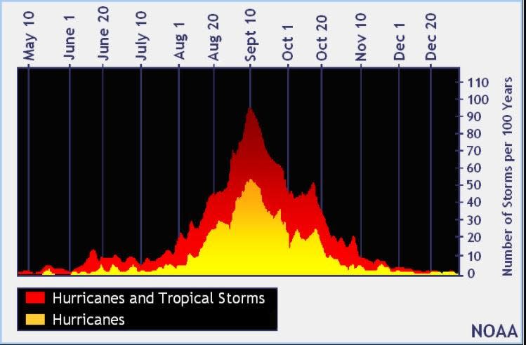
The peak of the season is Sept. 10, with the most activity happening between mid-August and mid-October, according to the Hurricane Center.
Tropical forecast over the next seven days
Excessive rainfall forecast
What's out there?
Systems currently being monitored by the National Hurricane Center.
What's next?
We will continue to update our tropical weather coverage daily. Download your local site's app to ensure you're always connected to the news. And look at our special subscription offers here.
This article originally appeared on Treasure Coast Newspapers: NHC tracking 3 systems. Tropical depressions possible later this week

