National Hurricane Center: Chances increasing for tropical depression to develop next week
Chances for development of a tropical wave in the eastern Atlantic are continuing to increase and the National Hurricane Center is now saying a tropical depression could form by early next week.
Chances for development have steadily increased throughout the day Friday. Predictions as of 8 p.m. Friday call for a 70 percent chance for development over the next seven days.
Tropical development is rare for this time of year in the eastern Atlantic, according to forecasters.
Abnormally warm waters for this time of year in the Atlantic, as well as the absence of Saharan dust in the atmosphere, are factors favoring the development of a tropical cyclone.
Some model support for tropical cyclone development in tropical Atlantic (S of 20°N and E of 60°W). National #Hurricane Center also has system in Tropical Weather Outlook. Only 3 June systems have been named in tropical Atlantic on record: Trinidad (1933), Ana (1979), Bret (2017) pic.twitter.com/fo1vT8bBv0
— Philip Klotzbach (@philklotzbach) June 15, 2023
"Only 3 June systems have been named in the tropical Atlantic on record: Trinidad (1933), Ana (1979), and Bret (2017)," according to Colorado State University hurricane forecaster Phil Klotzbach.
Coincidentally, if this system does strengthen, it would become Tropical Storm Bret.
"While it is rare to get a storm to develop over the south-central Atlantic in June, it is not completely unheard of," AccuWeather Tropical Meteorologist Alex DaSilva said. He added that there have been only a half-dozen or fewer tropical systems to develop in the area over the past 25 years in June.
"It looks like the road ahead for this tropical wave will be mostly favorable for development, especially in the longer term as it nears the Caribbean," DaSilva said.
Elsewhere in the Atlantic basin, the National Hurricane Center is continuing to monitor three other tropical waves, including one in the Caribbean Sea.
AccuWeather meteorologists said a disturbance could evolve into an organized tropical system the fourth week of June, moving from the western Caribbean Sea into the Gulf of Mexico.
Florida tornado: Tornado confirmed in Escambia County, one person killed
Tropical development historically happens close to North America and Central America in June.
Here's the latest update from the NHC as of 8 p.m. June 16:
What's out there and where are they?
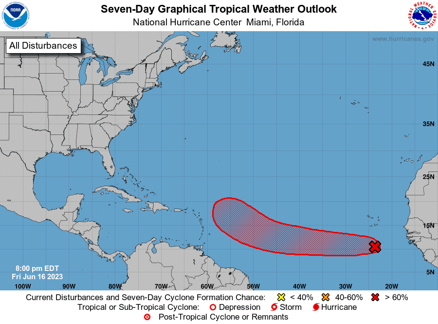
Tropical disturbance: A tropical wave located several hundred miles south of the Cabo Verde Islands is currently producing a broad area of disorganized showers and thunderstorms.
Tropical wave 2: A tropical wave in the central Atlantic is located between Cabo Verde and Brazil. It's moving west at 13 mph. Exact location: 32W from 02N to 12N.
Tropical wave 3: A tropical wave in the central Atlantic is located east-southeast of French Guiana off the coast of South America. It's moving west at 13 mph. Exact location: 45W from 02N to 11N.
Tropical wave 4: A tropical wave in the eastern Caribbean Sea is located west of St. Vincent. It's moving west at 13 mph. Exact location: 63W from eastern Venezuela at 04N to 13N.
Hurricane season predictions up in air: Hurricane season 2023 forecast keeping meteorologists guessing | WeatherTiger
How likely is it to strengthen?
Environmental conditions appear conducive for additional development, and a tropical depression is likely to form by the early to middle portion of next week while the system moves west at 15 to 20 mph across the eastern and central tropical Atlantic.
Formation chance through 48 hours: Low, near 30 percent.
Formation chance through seven days: High, 70 percent.
NOAA forecast: Hurricane forecasters watching tropical wave moving toward Americas from Africa
What is a tropical wave?
A tropical wave, also known as an easterly wave, is an elongated area of relatively low pressure that moves from east to west across the tropics. To the west of the system, there is often good weather. To the east, though, cloudiness and heavy rain are often found.
Tropical waves can lead to the formation of a tropical cyclone, according to NOAA.
Who is likely to be impacted?
It's too early at this time to determine if there will be any impact to the U.S. from the tropical wave in the eastern Atlantic but all residents in the Southeast should be prepared.
The tropical wave being closely monitored will not approach the Leeward and Windward islands of the eastern Caribbean until later next week, according to AccuWeather.
As a train of tropical waves move across the Atlantic, there may be some tropical development in waters surrounding Central America and southern Mexico during the third week and fourth week of June, according to AccuWeather.
Forecasters urge all residents to continue monitoring the tropics and to always be prepared.
What is El Niño?
El Niño is a natural climate pattern in which surface sea water temperatures in the central and eastern tropical Pacific Ocean are warmer than average. It occurs, on average, every two to seven years.
Here's what the return of El Niño means for hurricane season and Florida
El Niño is a natural climate pattern in which surface sea water temperatures in the central and eastern tropical Pacific Ocean are warmer than average. It occurs, on average, every two to seven years.
El Niño usually helps to suppress Atlantic hurricane activity, experts say.
El Niño “tends to lead to an increase in vertical wind shear, which tends to reduce the number of hurricanes in the tropical Atlantic,” said David DeWitt, director of the Climate Prediction Center.
El Niño is back: NOAA says. Will it help fuel Earth's hottest year on record?
But this year, forecasters say that may not happen, because of record hot Atlantic water temperatures that would counteract the El Niño winds that normally decapitate many storms.
While El Niño can't completely prevent hurricanes in the Atlantic, it often serves to limit hurricane formation and reduce hurricane landfalls along the East Coast, giving Florida and other hurricane-prone areas a break.
NOAA hurricane season forecast: NOAA predicts 'near normal' hurricane season with 12-17 named storms and 5-9 hurricanes
Weather watches and warnings issued for your area
If you can't see any local weather warnings here, you'll need to open this story in a web browser.
When is the Atlantic hurricane season?
The Atlantic hurricane season runs from June 1 through Nov. 30.
When is the peak of hurricane season?

The peak of the season is Sept. 10, with the most activity happening between mid-August and mid-October, according to the Hurricane Center.
Tropical forecast over the next seven days
Excessive rainfall forecast
What's out there?
Systems currently being monitored by the National Hurricane Center.

What's next?
We will continue to update our tropical weather coverage daily. Download your local site's app to ensure you're always connected to the news. And look at our special subscription offers here.
Contributor: Doyle Rice
This article originally appeared on Palm Beach Post: NHC: Tropical wave could become depression in Atlantic

