National Hurricane Center tracking 1 disturbance in Atlantic Ocean, 4 tropical waves
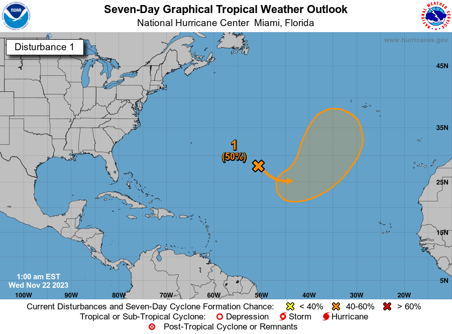
Chances have fallen even more for development of a disturbance in the central Atlantic, according to the latest advisory from the National Hurricane Center.
There is a low chance for the system to strengthen as it enters an area less favorable for development.
Invest 97L, which popped off off the coast of North Carolina last week, has now totally disappeared off the National Hurricane Center's tropical outlook map.
What's an invest? We explain and break down the weather forecaster's term
The Hurricane Center is monitoring four tropical waves in the Atlantic basin, including two in the Caribbean.
The next two names of the Atlantic hurricane season will be Emily and Franklin.
Here are the latest update from the NHC as of 2 p.m. Aug. 1:
What's out there and where are they?

Invest 96L: Showers and thunderstorms remain disorganized in association with a low pressure area located about 800 miles north-northeast of the northern Leeward Islands.
Tropical wave 1: A tropical wave in the eastern Atlantic is located northeast of Cabo Verde. It's moving west at 17 mph. Exact location: near 20W from 08N to 22N.
Tropical wave 2: A tropical wave in the central Atlantic is located west-northwest of Cabo Verde. It's moving west at 11 to 17 mph. Exact location: near 37W from 04N to 19N.
Tropical wave 3: An tropical wave in the eastern Caribbean tropical wave is located from western Puerto Rico to Venezuela. It's moving west at 11 to 17 mph.
Tropical wave 4: A tropical wave in the western Caribbean is located from the Gulf of Honduras across Central America and into the eastern Pacific.
How likely is it to strengthen?
Invest 96L: Environmental conditions are becoming less favorable for tropical cyclone formation, and the low is expected to merge with a frontal system over the north central Atlantic in about two to three days.
Formation chance through 48 hours: low, 30 percent.
Formation chance through seven days: low, 30 percent.
Spaghetti models for Invest 96L
Who is likely to be impacted?
Invest 96L: Aside from some bigger waves and strong wind impacts to shipping interest across the Atlantic, impacts to land look minimal at this time, according to AccuWeather.
It's too early at this time to determine if there will be any impact to the U.S. from the tropical waves.
Forecasters urge all residents to continue monitoring the tropics and to always be prepared.
Weather watches and warnings issued in Florida
If you can't see any local weather warnings here, you'll need to open this story in a web browser.
When is the Atlantic hurricane season?
The Atlantic hurricane season runs from June 1 through Nov. 30.
When is the peak of hurricane season?
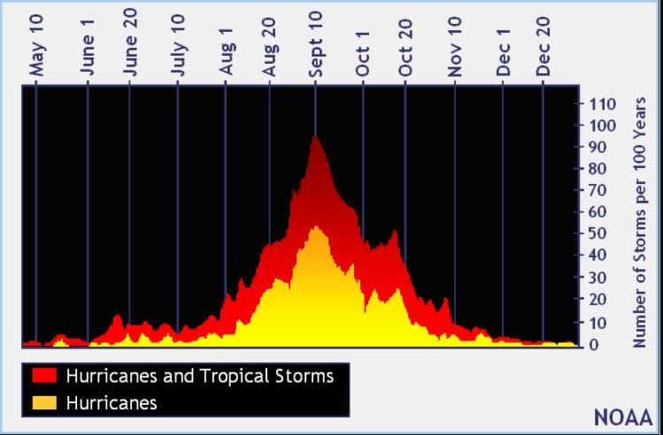
The peak of the season is Sept. 10, with the most activity happening between mid-August and mid-October, according to the Hurricane Center.
Tropical forecast over the next seven days
Excessive rainfall forecast
What's out there?
Systems currently being monitored by the National Hurricane Center.
What's next?
We will continue to update our tropical weather coverage daily. Download your local site's app to ensure you're always connected to the news. And look at our special subscription offers here.
This article originally appeared on Treasure Coast Newspapers: NHC tracking Invest 96L, four tropical waves

