Tropical Storm Lee forms, could be Category 4 hurricane in 5 days. Is Florida at risk?
- Oops!Something went wrong.Please try again later.
Newly formed Tropical Storm Lee is expected to "become a powerful hurricane by the end of the week," according to the National Hurricane Center.
The National Hurricane Center is tracking three systems in the Atlantic, half of what it was watching last week.
"The disturbance in the Central Atlantic will keep heading W-NW and needs to be monitored," said the Florida Public Radio Emergency Network. "Any impacts to the U.S. mainland would not be til (sic) next week."
AccuWeather forecasters predict Lee will become a Category 3 hurricane by Saturday morning east of Puerto Rico and quickly strengthen into a Category 4 storm by Sunday.
Monster in the making: Hurricane season forecast: Lee breaks record before it's even born
Latest indications suggest that the storm track could vary across a wide swath spanning from the U.S. East Coast northward to eastern Canada, or even skirt away from the coast entirely, according to AccuWeather.
Either way, most of the beaches along Eastern Seaboard of the U.S. are likely to have some stronger surf and dangerous rip currents.
"Interests across the Caribbean and along the East coast from Florida to Maine will need to pay close attention to this feature. Depending on the path this system takes, the expected time frame for potential impacts to the United States and Atlantic Canada may be Sept. 13-16," said AccuWeather Meteorologist Brandon Buckingham.
"Bermuda should absolutely be watching this system as should eastern North America especially this time of year," said The Weather Channel meteorologist Jim Cantore.
#invest95L is the one to watch this week and next likely next as it ramps up to an MDR (main development region) hurricane (and likely a healthy on) in time as suggested by guidance. Track guidance ahas also trended farther away from the Leeward Islands, but until its official… pic.twitter.com/tjvgm4b7cT
— Jim Cantore (@JimCantore) September 5, 2023
"The good news is, 95L is on the radar now and we likely have over a week to watch it."
The Florida Division of Emergency Management said the system poses "no direct threat to Florida over the next 7-10 days, at least," but the system should continue to be monitored.
Elsewhere in the Atlantic is a tropical wave designated as Invest 96L is moving off the coast of Africa and could become a tropical depression later this week.
Post-Tropical Cyclone Franklin is still hanging around. Located several hundred miles north of the Azores, the system could acquire some subtropical or tropical characteristics as it moves south between the Azores and Portugal.
Next named storms of the season will be Margot and Nigel.
Special note on the NHC cone: The forecast track shows the most likely path of the center of the storm. It does not illustrate the full width of the storm or its impacts, and the center of the storm is likely to travel outside the cone up to 33% of the time.
Here's the latest update from the NHC as of 5 p.m.:
Tropical Storm Lee expected to become major hurricane

Location: 1,315 miles east of the Lesser Antilles
Maximum sustained winds: 45 mph
Movement: west-northwest at 16 mph
At 5 p.m., the center of Tropical Storm Lee was located 1,315 miles east of the Lesser Antilles.
The storm is moving toward the west-northwest near 16 mph, and this motion is expected to continue for the next few days.
Maximum sustained winds are near 45 mph, with higher gusts. The tropical storms forecast to be a hurricane in a couple of days and could become a major hurricane in a few days.
The estimated minimum central pressure is 1005 mb.
The tropical storm should be moving over record-warm waters east of the Lesser Antilles. That, combined with low to no wind shear could mean rapid intensification by the end of the week.
All indications are that the tropical storm will become a strong hurricane by the end of the forecastperiod.
Tropical Storm Lee could be Category 4 hurricane in 5 days
Tropical Storm Lee is forecast to become a major hurricane by this weekend and could bring impacts to the Leeward Islands by that time. While it is too soon to determine the location and magnitudeof these possible impacts, residents in this area should monitor the storm, NHC forecasters said.
Prediction and timing of winds:
12 hours: 60 mph
24 hours; 70 mph
36 hours: 80 mph
48 hours: 90 mph
60 hours: 105 mph
72 hours: 125 mph
96 hours: 140 mph
120 hours: 145 mph
Spaghetti models for Tropical Storm Lee
Special note about spaghetti models: Illustrations include an array of forecast tools and models, and not all are created equal. The hurricane center uses only the top four or five highest performing models to help make its forecasts.
Most spaghetti models keep Tropical Storm Lee north of the Caribbean. However, Bermuda could face a major hurricane next week.
Tropical Storm Lee tracker
What else is out there and how likely are they to strengthen?
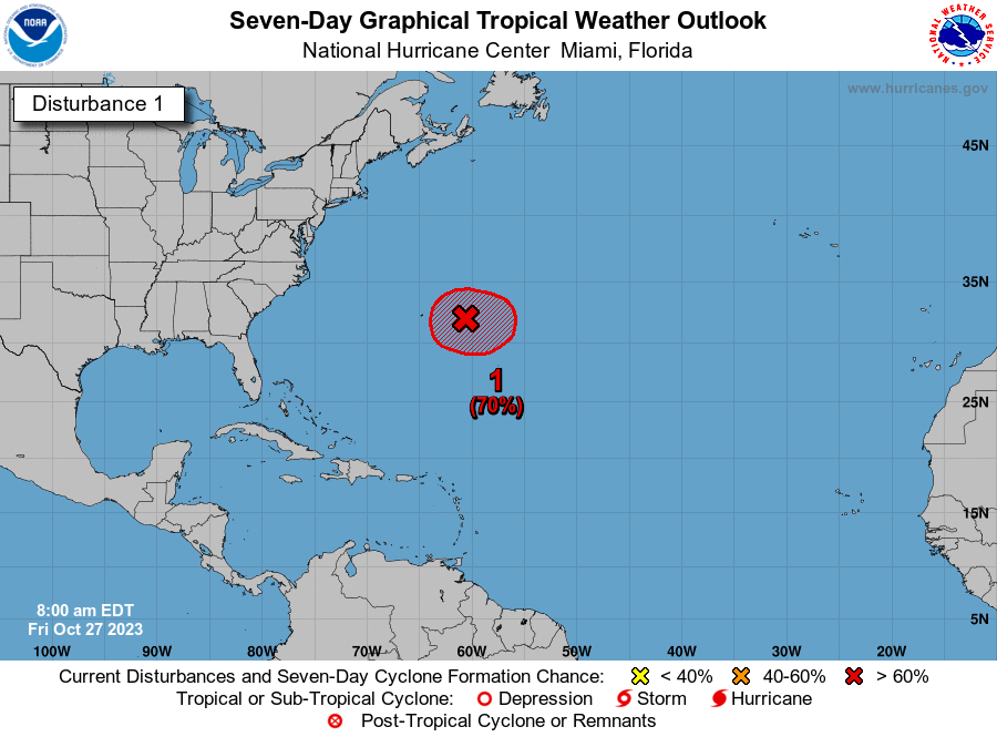
Invest 96L: A broad low pressure system associated with a strong tropical wave off the coast of West Africa, is producing a large area of showers and thunderstorms.
Environmental conditions appear conducive for gradual development, and a tropical depression could form over the far eastern tropical Atlantic during the middle to latter part of the week while the system moves west-northwestward at 10 to 15 mph.
This system is expected to move across the Cabo Verde Islands Wednesday night and Thursday, and interests there should monitor its progress.
Formation chance through 48 hours: low, 30 percent.
Formation chance through seven days: high, 70 percent.
Post-Tropical Cyclone Franklin: Post-Tropical Cyclone Franklin is located a few hundred miles northeast of the Azores, and is forecast to move quickly east-southeastward towards warmer waters east of the Azores.
This system could acquire some subtropical or tropical characteristics later this week or this weekend while it moves erratically between the Azores and Portugal.
Formation chance through 48 hours: low, near 0 percent.
Formation chance through 7 days: low, 20 percent.
Who is likely to be impacted?
It's too early at this time to determine if there will be any impact to the U.S. from Invest 95L or the tropical wave. Franklin poses no threat to the U.S.
Forecasters urge all residents to continue monitoring the tropics and to always be prepared.
Weather watches and warnings issued in Florida
When is the Atlantic hurricane season?
The Atlantic hurricane season runs from June 1 through Nov. 30.
When is the peak of hurricane season?
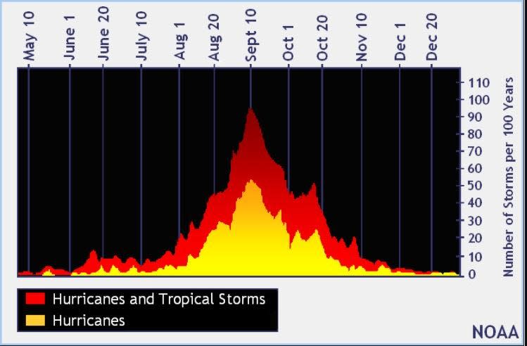
The peak of the season is Sept. 10, with the most activity happening between mid-August and mid-October, according to the Hurricane Center.
Tropical forecast over the next seven days
Excessive rainfall forecast
What's out there?
Systems currently being monitored by the National Hurricane Center.

Noaa
Embedded content: https://www.nhc.noaa.gov/xgtwo/two_atl_0d0.png?052051
What's next?
We will continue to update our tropical weather coverage daily. Download your local site's app to ensure you're always connected to the news. And look at our special subscription offers here.
This article originally appeared on Treasure Coast Newspapers: Tropical Storm Lee forms, expected to become major hurricane

