National Hurricane Center tracking disturbance in eastern Atlantic, 3 tropical waves
Three days after the first named storm of the 2023 Atlantic hurricane season formed, the National Hurricane Center is showing a new disturbance in the eastern Atlantic.
The system could develop some subtropical characteristics over the next couple of days before moving into cooler waters later in the week, according to NHC forecasters.
The 2023 Atlantic hurricane season got off to a quick start with the formation of Tropical Storm Arlene Friday afternoon, the second day of the season.
The short-lived storm weakened into a tropical depression Saturday morning and then a remnant low by Saturday afternoon.
Do you live in an evacuation zone? How do you know if you live in an evacuation zone? We explain how to find your zone
Florida may not catch a break: AccuWeather issues 2023 hurricane season forecast, predicting 11-15 named storms
The next named storm of the season will be Bret.
Here's the latest update from the NHC as of 8 a.m. June 5:
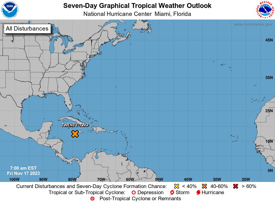
What's out there and where are they?
Non-tropical area of low pressure: Disorganized showers and thunderstorms over the northeastern Atlantic Ocean between the Azores and Canary Islands are associated with a complex non-tropical area of low pressure.
Tropical wave 1: A tropical wave in the Atlantic is located west of Cabo Verde. It's moving west at 11 mph. Exact location: 31W from 14N south.
Tropical wave 2: Another Atlantic tropical wave is located east of St. Lucia. It's moving west at about 13 mph. Exact location: 52W from 14N south.
Tropical wave 3: A tropical wave in the Caribbean is located west of St. Lucia. It's moving west at 7 mph. Exact location: 65W from 14N south.
How likely are they to strengthen?
Non-tropical area of low pressure: This system could develop some subtropical characteristics during the next couple of days while it moves little. By late in the week, however, the system is expected to move northeast over cooler waters, ending its chances of subtropical development.
Formation chance through 48 hours: low, 10 percent.
Formation chance through seven days: low, 10 percent.
Who is likely to be impacted?
The non-tropical area of low pressure in the eastern Atlantic is not expected to impact the U.S.
It's too early at this time to determine if there will be any impact to the U.S. from the tropical waves.
Forecasters urge all residents to continue monitoring the tropics and to always be prepared.
Weather watches and warnings issued for your area
If you can't see any local weather warnings here, you'll need to open this story in a web browser.
When is the Atlantic hurricane season?
The Atlantic hurricane season runs from June 1 through Nov. 30.
When is the peak of hurricane season?
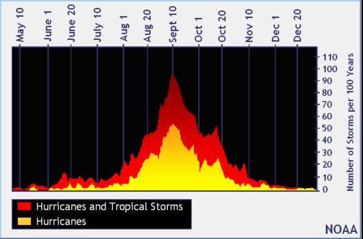
The peak of the season is Sept. 10, with the most activity happening between mid-August and mid-October, according to the Hurricane Center.
Tropical forecast over the next seven days
Excessive rainfall forecast
What's out there?
Systems currently being monitored by the National Hurricane Center.
What's next?
We will continue to update our tropical weather coverage daily. Download your local site's app to ensure you're always connected to the news. And look at our special subscription offers here.
This article originally appeared on Naples Daily News: Tropics watch: NHC tracking system in Atlantic, 3 tropical waves

