National Hurricane Center tracking 2 systems. See how Invest 93L could impact Florida
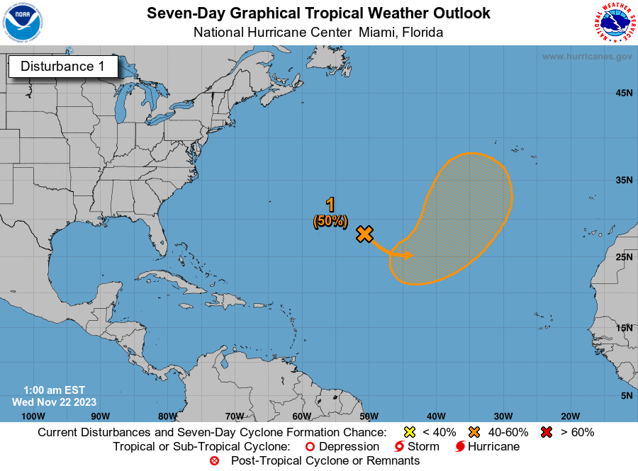
Chances for development have picked up slightly for Invest 93L in the Gulf of Mexico, according to the latest advisory from the National Hurricane Center.
The system is one of two forecasters are tracking in the Atlantic basin.
Invest 93L has a short window of opportunity to develop before it merges with another system over the western Gulf of Mexico.
Regardless of tropical development, Invest 93L is expected to bring gale-force winds over portions of the northern Gulf of Mexico by Wednesday and potentially heavy rain along the Gulf Coast later this week.
The Florida Division of Emergency Management also predicted the "system will bring heavy rainfall across Florida by midweek."
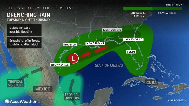
AccuWeather forecasters are predicting a "double-whammy" of tropical moisture will bring drenching rainfall to the Gulf Coast this week.
While wind shear is working against a developing system, "warm waters could help a new tropical depression brew before winds become too disruptive for the tropical low to strengthen, according to AccuWeather.
"Whether or not an organized tropical system develops, many of the impacts will remain the same," said AccuWeather Meteorologist Alex DaSilva.
Widespread showers and thunderstorms are expected all along the Gulf coast from Texas to the southern tip of Florida. The storm's track will largely determine the location of the heaviest rain but will most likely target the Gulf coast's central and eastern parts into Thursday.
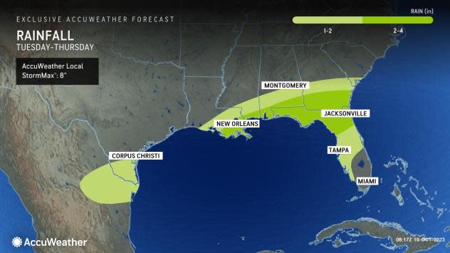
Rainfall amounts of 1-2 inches are expected to be common from the Texas-Louisiana border to South Carolina and northern Florida, with more isolated rain totals of 3 or 4 inches. Should the tropical low track closer to the coast, it may bring even higher rain amounts, according to AccuWeather.
Farther east in the Atlantic is Invest 92L. The National Hurricane Center is predicting it will become a tropical depression in the next couple of days.
Here's the latest update from the NHC as of 2 p.m.:
What is out there and how likely are they to strengthen?
Invest 93L: Showers and thunderstorms have not become any better organized this afternoon in association with an area of low pressure over the southwestern Gulf of Mexico.
Environmental conditions appear only marginally favorable and this system has a short window to develop further over the next day or so. By Wednesday morning, the system is forecast to merge with a developing frontal boundary over the western Gulf of Mexico.
An Air Force Reserve Reconnaissance aircraft is in route to investigate the system this afternoon and will provide more information about the system's structure.
Regardless of tropical cyclone development, the system is forecast to produce gale-force winds over portions of the northern Gulf of Mexico by tomorrow, and potentially heavy rainfall along the Gulf Coast by the latter portion of this week.
Formation chance through 48 hours: low, 30 percent.
Formation chance through 7 days: low, 30 percent.
Invest 92L: A broad area of low pressure located several hundred miles southwest of the Cabo Verde Islands continues to produce a large area of showers and thunderstorms.
This activity has become a bit more concentrated while also showing signs of organization, and environmental conditions appear conducive for additional development.
A tropical depression is likely to form during the next couple of days while the system moves west-northwestward or northwestward across the eastern and central tropical Atlantic.
Formation chance through 48 hours: high, 80 percent.
Formation chance through seven days: high, 80 percent.
Spaghetti models for Invest 93L
Special note about spaghetti models: Illustrations include an array of forecast tools and models, and not all are created equal. The hurricane center uses only the top four or five highest performing models to help make its forecasts.
Spaghetti models for Invest 92L
Who is likely to be impacted?
Invest 93L: Regardless of tropical cyclone development, the system is forecast to produce gale-force winds over portions of the northern Gulf of Mexico by tomorrow, and potentially heavy rainfall along the Gulf Coast by the latter portion of this week.
Rainfall amounts of 1-2 inches are expected to be common from the Texas-Louisiana border to South Carolina and northern Florida, with more isolated rain totals of 3 or 4 inches. Should the tropical low track closer to the coast, it may bring even higher rain amounts, according to AccuWeather.
Forecasters urge all residents to continue monitoring the tropics and to always be prepared.
Weather watches and warnings issued in Florida
When is the Atlantic hurricane season?
The Atlantic hurricane season runs from June 1 through Nov. 30.
When is the peak of hurricane season?
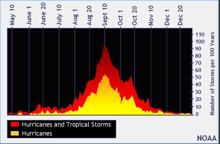
The peak of the season is Sept. 10, with the most activity happening between mid-August and mid-October, according to the Hurricane Center.
Tropical forecast over the next seven days
Excessive rainfall forecast
What's out there?
Systems currently being monitored by the National Hurricane Center.

Noaa
Embedded content: https://www.nhc.noaa.gov/xgtwo/two_atl_0d0.png?052051
What's next?
We will continue to update our tropical weather coverage daily. Download your local site's app to ensure you're always connected to the news. And look at our special subscription offers here.
This article originally appeared on Treasure Coast Newspapers: NHC tracking Invests 93L, 92L. Florida impacts, spaghetti models

