National Hurricane Center tracking long-lived Tropical Storm Philippe, 2 tropical waves
The National Hurricane Center continues to track Tropical Storm Philippe, a storm that's been around since Sept. 23.
Philippe is bringing heavy rain and flash floods as it moves across portions of the British and U.S. Virgin Islands.
The long-lived storm is moving to the north-northwest and is expected to travel another 2,000 miles toward Atlantic Canada or even New England, according to AccuWeather and the National Hurricane Center.
"Philippe might bend back to the left a bit and approach Atlantic Canada or eastern Maine in 3-4 days," according to the National Hurricane Center.
AccuWeather's forecast takes Philippe into Nova Scotia, Canada, late Sunday to early Monday, but there is the potential for it to take more of a westward jog into northern New England, forecasters said.
Philippe is forecast to take a more northerly path much of this week and into the weekend. Bermuda will be next in Philippe's path, according to AccuWeather.
The tropical storm is not expected to pose a direct threat to Florida, according to the Florida Division of Emergency Management.
We're currently in the middle of the busiest period of the Atlantic hurricane season. The season runs from June 1 through Nov. 30, with the most-active period running from mid-August through mid-October.
Through the end of September, the Atlantic has produced 81 named storm days, according to Colorado State University hurricane expert Philip Klotzbach.
"That's the 6th-most on record through 9/30, trailing (in descending order from most): 1933, 1995, 2005, 2004, 2020.
"The Atlantic has now generated enough Accumulated Cyclone Energy to officially meet NOAA’s definition of an above-normal #hurricane season. 2022 was classified as near-normal. 2016, 2018, 2019, 2021 were defined as above-normal, while 2017 and 2020 were extremely active."
Here's the latest information as of 11 a.m.:
Tropical Storm Philippe

Special note on the NHC cone: The forecast track shows the most likely path of the center of the storm. It does not illustrate the full width of the storm or its impacts, and the center of the storm is likely to travel outside the cone up to 33% of the time.
Location: 200 miles north-northwest of St. Thomas; 1,015 miles southeast of West Palm Beach
Maximum wind speed: 45 mph
Direction: north-northwest at 7 mph
At 11 a.m., the center of Tropical Storm Philippe was located near latitude 21.2 North, longitude 65.7 West. Philippe is moving toward the north-northwest near 7 mph, and this motion is expected to continue today. A northward motion at a faster forward speed is forecast to begin tonight and continue into the weekend.
On the forecast track, the center of Philippe will approach Bermuda Thursday night and Friday.
Maximum sustained winds are near 45 mph, with higher gusts. Little change in strength is forecast during the next couple of days. Some strengthening is possible late this week.
Tropical-storm-force winds extend outward up to 150 miles to the east of the center.
The estimated minimum central pressure is 1004 mb.
September look at the tropics: September saw 7 named storms in tropics, including 3 hurricanes
Forecast path: Spaghetti models for Philippe
Special note about spaghetti models: Illustrations include an array of forecast tools and models, and not all are created equal. The hurricane center uses only the top four or five highest performing models to help make its forecasts.
What else is out there?
There are two tropical waves in the Atlantic being monitored by the National Hurricane Center. Both are moving west.
More on Tropical Storm Philippe: Tropical Storm Philippe threatens Leeward Islands
Who is likely to be impacted?
Philippe is expected to bring 4 to 8 inches of rain to the U.S. and British Virgin Islands, with some areas getting up to 12 inches.
Gusty winds are likely to continue across portions of the Virgin Islands through early today.
Swells generated by Philippe will affect portions of the Atlantic coasts of the northern Leeward Islands, the Virgin Islands, and Puerto Rico for another couple of days. Swells are expected to reach Bermuda by late Thursday.
Forecasters urge all residents to continue monitoring the tropics and to always be prepared.
Weather watches and warnings issued in Florida
When is the Atlantic hurricane season?
The Atlantic hurricane season runs from June 1 through Nov. 30.
When is the peak of hurricane season?
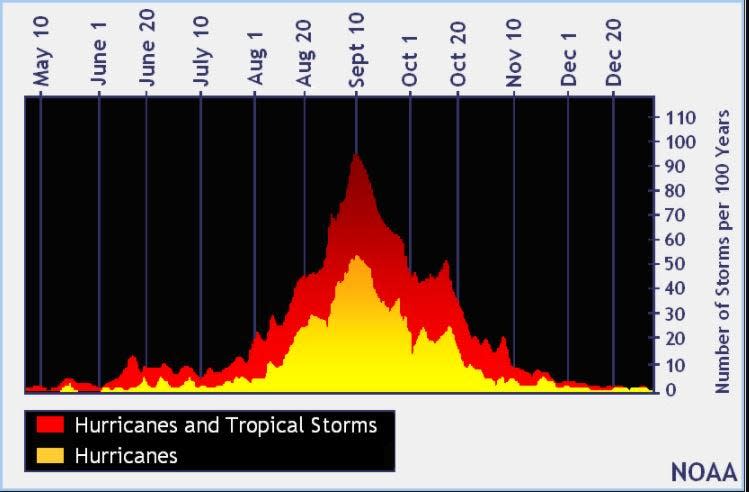
The peak of the season is Sept. 10, with the most activity happening between mid-August and mid-October, according to the Hurricane Center.
Tropical forecast over the next seven days
Excessive rainfall forecast
What's out there?
Systems currently being monitored by the National Hurricane Center.

Noaa
Embedded content: https://www.nhc.noaa.gov/xgtwo/two_atl_0d0.png?052051
What's next?
We will continue to update our tropical weather coverage daily. Download your local site's app to ensure you're always connected to the news. And look at our special subscription offers here.
This article originally appeared on Treasure Coast Newspapers: NHC tracking Tropical Storm Philippe. Florida impact, forecast path

