National Hurricane Center tracking 3 disturbances. One bringing heavy rain to NE Florida
Not only are chances continuing to increase for a tropical depression to form in the Atlantic, but forecasters are watching two other disturbances, including one that has moved inland along the Northeast Florida coast, according to the latest advisory from the National Hurricane Center.
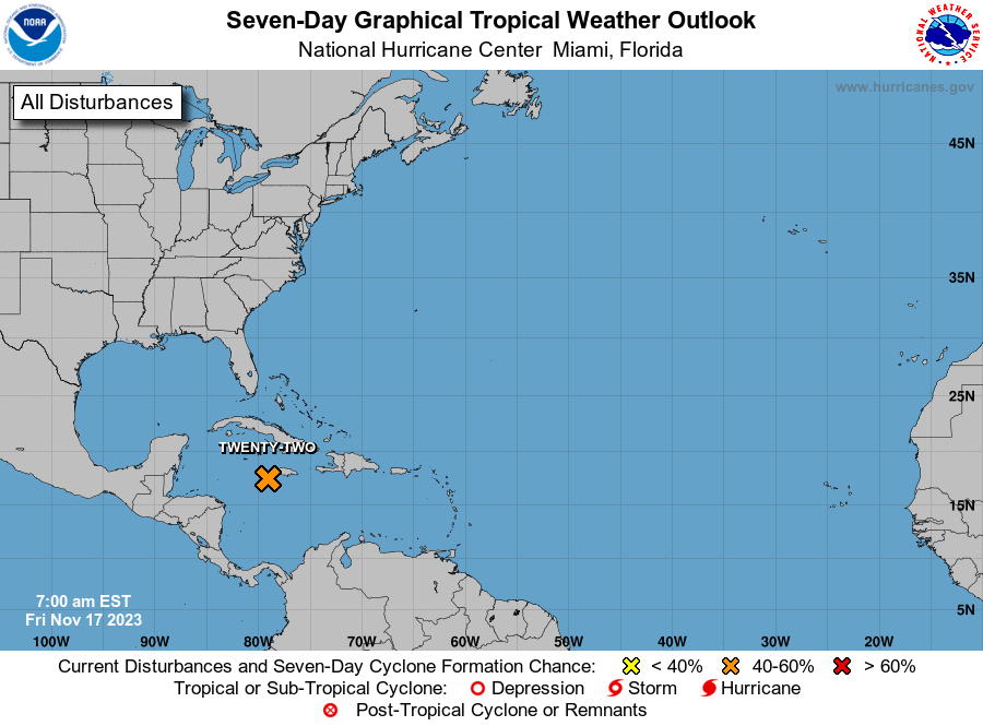
Chances have increased to 60 percent for tropical development of a system in the central Atlantic, according to the National Hurricane Center.
At 8 a.m., a system of low pressure was identified east of Jacksonville. The weak area of low pressure has now moved inland over Northeast Florida, bringing locally heavy rainfall. Additional tropical development is not expected.
The third system is located in the southwestern Caribbean and significant development is not anticipated.
AccuWeather meteorologists are predicting a medium chance for the wave in the central Atlantic to develop into a tropical depression or named tropical storm through the end of July.
"This feature is expected to pass to the northeast of the Leeward Islands in the Caribbean late this weekend and then curve northward into the western or central Atlantic next week," said AccuWeather Senior Meteorologist Adam Douty.
Hurricane-prone counties: Here's a list of counties most hurricane-prone, potentially most expensive in Florida and other states
"While this feature does not appear to be a significant threat to the Caribbean or the U.S., it will need to be monitored for potential impacts to Bermuda around the middle of next week," Douty said.
If sustained winds reach 39 mph, the system could become the fifth named storm of the Atlantic hurricane season: Emily.
Elsewhere in the Atlantic basin — which includes the Atlantic Ocean, Caribbean Sea and Gulf of Mexico — forecasters are watching three other tropical waves, including one in the Caribbean.
Drenching downpours and locally gusty thunderstorms associated with a tropical disturbance no longer on the Hurricane Center's tropical outlook map are expected to continue moving across parts of Florida today, according to AccuWeather meteorologists.
Fort Lauderdale Airport received a record 6.19 inches of rain Thursday, smashing the previous daily record of 2.48 inches set in 1995, according to the National Weather Service Miami.
It was was the most rain recorded at the airport for any day in July. The previous record was 5.68 inches, set July 13, 2013.
Here's the latest update from the NHC as of 2 p.m. July 28:
What's out there and where are they?

Disturbance 1: A tropical wave located about midway between the Cabo Verde Islands and the Lesser Antilles continues to produce disorganized cloudiness and showers.
Disturbance 2: Satellite, surface, and radar data show that a weak area of low pressure has moved just inland near the Florida/Georgia border.
Disturbance 3: A large area of disorganized showers and thunderstorms over the southwestern Caribbean Sea and portions of Central America are associated with a tropical wave and broad area of low pressure located near the eastern coast of Central America.
Tropical wave 1: A tropical wave in the central Atlantic is located northwest of Cabo Verde. It's moving west at 17 mph. Exact location: near 38W from 03N to 19N.
Tropical wave 2: A tropical wave in the western Atlantic is located east of the British Virgin Islands. It's moving west at 17 to 23 mph. Exact location: near 58W from 03N to 19N.
Tropical wave 3: A tropical wave in the central Caribbean is located south of Cuba. It's moving west at 17 mph. Exact location: near 80W from 04N to 20N.
Shark predictions? Could sharks make good hurricane hunters? Why scientists say they can help with forecasts
How likely are they to strengthen?
Disturbance 1: Environmental conditions are expected to be favorable for gradual development of this system during the next few days, and a tropical depression could form early next week while thedisturbance moves west-northwestward to northwestward at about 15 mph.
Formation chance through 48 hours: low, low 20 percent.
Formation chance through 7 days: medium, 60 percent.
Disturbance 2: This system is forecast to move north-northwestward over inland portions of eastern Georgia through tonight, and no additional development is expected.
Formation chance through 48 hours: low, near 0 percent.
Formation chance through 7 days: low, near 0 percent.
Disturbance 3: This system is forecast to move westward over Central America later today or tonight, and significant development is not anticipated in the Atlantic basin.
In the Caribbean:
Formation chance through 48 hours: low, 10 percent.
Formation chance through 7 days: low, 10 percent.
Hurricane history: The eras tour: What past hurricanes tell us about dangers for 2023 season

However, once it enters the eastern Pacific, an area of low pressure is expected to form off the coast of southern Mexico later this weekend. Thereafter, gradual development of this system is forecast and atropical depression will likely form while it moves generally west-northwestward at 10 to 15 mph, roughly parallel to the coasts of southern and southwestern Mexico.
In the eastern Pacific:
Formation chance through 48 hours: low, 10 percent.
Formation chance through 7 days: high, 70 percent.
Who is likely to be impacted?
Disturbance 2: The disturbance could bring locally heavy rainfall to portions of northeastern Florida, eastern Georgia, and eastern South Carolina during the next day or so.
Disturbance 3: Regardless of development, locally heavy rainfall is possible over portions of Nicaragua and Honduras during the next day or so.
It's too early at this time to determine if there will be any impact to the U.S. from the tropical waves.
Forecasters urge all residents to continue monitoring the tropics and to always be prepared.
Radar: Track storms through National Weather Service Jacksonville

Weather watches and warnings issued in Florida
When is the Atlantic hurricane season?
The Atlantic hurricane season runs from June 1 through Nov. 30.
When is the peak of hurricane season?
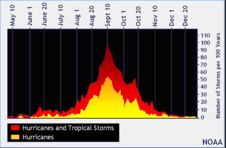
The peak of the season is Sept. 10, with the most activity happening between mid-August and mid-October, according to the Hurricane Center.
Tropical forecast over the next seven days
Excessive rainfall forecast
What's out there?
Systems currently being monitored by the National Hurricane Center.
What's next?
We will continue to update our tropical weather coverage daily. Download your local site's app to ensure you're always connected to the news. And look at our special subscription offers here.
This article originally appeared on Treasure Coast Newspapers: NHC tracking system with 60% chance of become tropical depression

