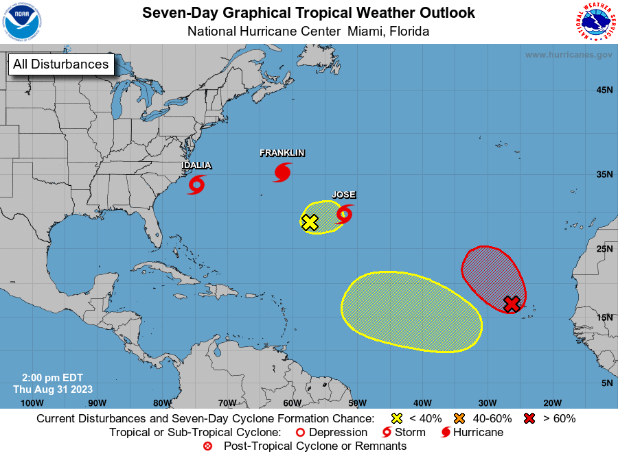
National Hurricane Center tracking 3 systems in Atlantic basin, including 1 east of Florida
A tropical disturbance east of Florida continues to have a low chance for development but officials are advising residents to take precautions and be prepared.
"Some models do track this disturbance toward the east coast of Florida later on this week," according to the Florida Public Radio Emergency Network.
"Even though conditions are only marginally favorable for development into a significant storm, residents should take precautions and make sure we are prepared no matter what."
The disturbance is one of three on the National Hurricane Center's tropical outlook map, according to the latest advisory.
Invest 95L is expected to bring heavy rain and gusty winds to the eastern Caribbean islands through the middle of the week.
WeatherTiger: What deranged heat and sea temps tell us about hurricane season
The presence of both dry air and strong wind shear make conditions in the Caribbean Sea hostile for tropical development.
There have been four named tropical systems this season. On average, the fourth named tropical storm of the season usually occurs around Aug. 15.
The next named storm of the 2023 Atlantic hurricane season will be Emily.
Here's the latest update from the NHC as of 2 p.m. July 25:
What's out there and where are they?

Invest 95L: A tropical wave over the southeastern Caribbean Sea is producing a large area of disorganized showers and thunderstorms, with some locally heavy rains over portions of the adjacent land areas.
Trough of low pressure: A weak trough of low pressure is located a few hundred miles south-southwest of Bermuda and east of Florida.
Eastern Atlantic tropical wave: A tropical wave is located south of the Cabo Verde Islands.
Tropical wave 1: A tropical wave in the eastern Atlantic is located northwest of Cabo Verde. It's moving west at 17 mph. Exact location: along 36W, south of 19N.
Tropical wave 2: A tropical wave, associated with Invest 95L, is near the Lesser Antilles. It's moving west at 23 mph. Exact location: extending from 20N 59W to 05N 61W.
Sharks and hurricanes? Could sharks make good hurricane hunters? Why scientists say they can help with forecasts
How likely are they to strengthen?
Invest 95L: Development of this system is not expected while it continues to move rapidly westward over the Caribbean during the next few days.
Formation chance through 48 hours: low, 10 percent.
Formation chance through seven days: low, 10 percent.
➤ Spaghetti models for Invest 95L
Trough of low pressure: Significant development of this system appears unlikely while it moves move west-northwestward toward the southeastern U.S. coast over the next several days.
Formation chance through 48 hours: low, near 0 percent.
Formation chance through seven days: low, 10 percent.
Eastern Atlantic tropical wave: Some development of this system is possible later this week and into the weekend while it moves westward to west-northwestward over the tropical Atlantic.
Formation chance through 48 hours: low, near 0 percent.
Formation chance through 7 days: low, 20 percent.
Who is likely to be impacted?
Invest 95L: This system poses no threat to Florida over the next five to seven days, according to the Florida Division of Emergency Management.
Regardless of development, locally heavy rains and strong gusty winds are expected acrossportions of the Lesser Antilles during the next day or so, according to the National Hurricane Center.
Whether or not the system strengthens, many of the eastern Caribbean islands, from Barbados and Martinique to St. Lucia, St. Vincent and the Grenadines can expect an uptick in rainfall through the middle of the week with locally heavy downpours, according to AccuWeather.
"This system has the potential to bring flooding rainfall to some of the islands [in the Caribbean]," AccuWeather Hurricane Expert Dan Kottlowski said.
"This system may never gather a name, but it will create big impacts to the islands including gale-force wind gusts and probably more rainfall than what occurred with Bret earlier this season."
Trough of low pressure: Some models show the system moving toward the east coast of Florida later this week. Although conditions are marginally favorable for development into a significant storm, residents were advised to be prepared
It's too early at this time to determine if there will be any impact to the U.S. from the tropical waves.
Forecasters urge all residents to continue monitoring the tropics and to always be prepared.
Weather watches and warnings issued in Florida
When is the Atlantic hurricane season?
The Atlantic hurricane season runs from June 1 through Nov. 30.
When is the peak of hurricane season?
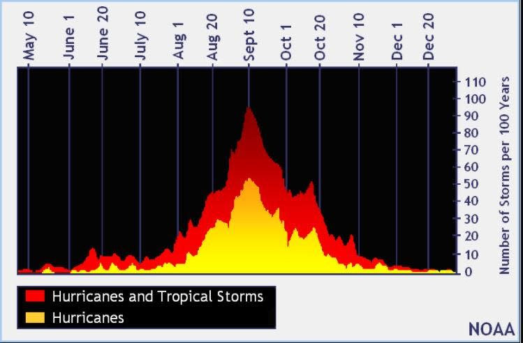
The peak of the season is Sept. 10, with the most activity happening between mid-August and mid-October, according to the Hurricane Center.
Tropical forecast over the next seven days
Excessive rainfall forecast
What's out there?
Systems currently being monitored by the National Hurricane Center.
What's next?
We will continue to update our tropical weather coverage daily. Download your local site's app to ensure you're always connected to the news. And look at our special subscription offers here.
This article originally appeared on Florida Times-Union: NHC tracking 3 tropical disturbances, including one east of Florida
