National Hurricane Center tracking new disturbance east of Florida
The National Hurricane Center is tracking several systems in the Atlantic basin, including a new one east of Florida, according to the latest advisory.
While environmental conditions are generally favorable for development, the system located a few hundred miles south of Bermuda has a 20 percent for development over the next seven days.
Gradual development of this system is possible as it moves toward the southeastern U.S. coast later this week and into the weekend, forecasters said.
Don strengthened into the first hurricane of the Atlantic hurricane season July 22 before weakening less than 24 hours later.
As of the 11 a.m. advisory, Don has become a post-tropical cyclone. No further advisories will be issued.
On average, the first hurricane of the season is Aug. 11, according to NOAA.
Invest 95L, which is heading into the eastern Caribbean, has a low chance for development and is expected to run into problems.
Sharks and hurricane forecasts? Could sharks make good hurricane hunters? Why scientists say they can help with forecasts
Dry air and strong wind shear make conditions in the Caribbean hostile for any tropical development.
However, looking into next week, as the calendar turns from July to August, AccuWeather meteorologists say there is more potential for tropical systems to develop in the Atlantic.
AccuWeather meteorologists say that more tropical development is possible during the final week of July.
In 2022, there were no named storms in the Atlantic during the entire month of August for the first time in 25 years.
Here's the latest update from the NHC as of 2 p.m. July 24:
Post-Tropical Cyclone Don

Location: 585 miles east of Cape Race, Newfoundland
Maximum wind speed: 45 mph
Direction: east-northeast at 20 mph
What's out there and where are they?
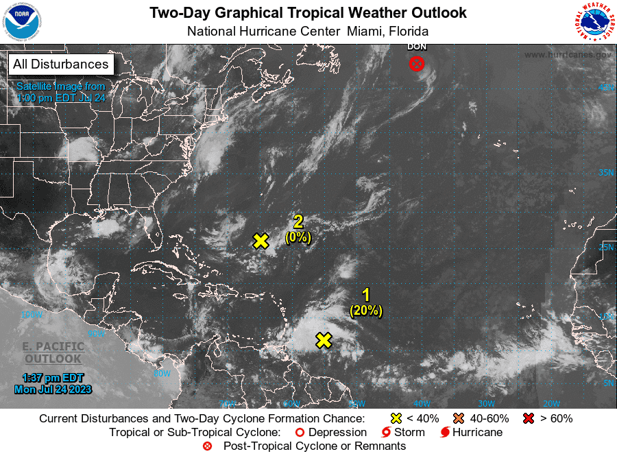
Invest 95L: A tropical wave is located a few hundred miles east of the Windward Islands.
Trough of low pressure: A weak trough of low pressure is located a few hundred miles south of Bermuda and east of Florida.
Post-Tropical Cyclone Don: At 11 a.m, the center of Tropical Storm Don was located 585 miles east of Cape Race, Newfoundland. Exact location: near latitude 47.6 North, longitude 40.7 West.
Tropical wave 1: A tropical wave in the eastern Atlantic is located northwest of Cabo Verde. It's moving west at 11 mph. Exact location: along 26W from 03N to 18N.
Tropical wave 2: A tropical wave in the central Atlantic is located between Puerto Rico and Cabo Verde. It's moving west at 11 to 17 mph. Exact location: along 42W from 03N to 19N.
How to track tropical waves, storms: We explain how to track tropical storms and how far typical landmarks are from Florida
How likely are they to strengthen?

Post-Tropical Cyclone Don: Maximum sustained winds are near 45 mph, with higher gusts. Don should continue to gradually weaken, before dissipating Tuesday. Tropical-storm-force winds extend outward up to 70 miles, from the center.
Invest 95L: Although this system has not become any better organized since yesterday, some slow development remains possible during the next couple of days while it moves westward near 20 mph across the tropical Atlantic and into the eastern Caribbean Sea.
Formation chance through 48 hours: low, 20 percent.
Formation chance through seven days: low, 20 percent.
➤ Spaghetti models for Invest 95L
Trough of low pressure: Environmental conditions are expected to become marginally conducive for some gradual development of this system as it moves towards the southeastern U.S. coast later this week and into the weekend.
Formation chance through 48 hours: low, near 0 percent.
Formation chance through 7 days: low, 20 percent.
Who is likely to be impacted?
Don is not expected to have any impact on land.
It's too early at this time to determine if there will be any impact to the U.S. from Invest 95L or the trough of low pressure.
Regardless of development, locally heavy rains and strong gusty winds associated with Invest 95L can be expected across portions of the Lesser Antilles during the next day or two. Environmental conditions are expected to become unfavorable for development of this system by the middle of the week.
Forecasters urge all residents to continue monitoring the tropics and to always be prepared.
Weather watches and warnings issued in Florida
If you can't see any local weather warnings here, you'll need to open this story in a web browser.
When is the Atlantic hurricane season?
The Atlantic hurricane season runs from June 1 through Nov. 30.
When is the peak of hurricane season?

The peak of the season is Sept. 10, with the most activity happening between mid-August and mid-October, according to the Hurricane Center.
Tropical forecast over the next seven days
Excessive rainfall forecast
What's out there?
Systems currently being monitored by the National Hurricane Center.
What's next?
We will continue to update our tropical weather coverage daily. Download your local site's app to ensure you're always connected to the news. And look at our special subscription offers here.
This article originally appeared on Treasure Coast Newspapers: NHC tracking system off Florida, Invest 95L, 2 tropical waves

