National Hurricane Center tracking Tropical Storms Philippe, Rina. See spaghetti models
The National Hurricane Center is tracking two tropical storms: Philippe and Rina.
Tropical Storm Philippe is barely moving east of the Northern Leeward Islands, while Tropical Storm Rina is maintaining 45-mph winds slightly to its east, according to the latest advisory from the Hurricane Center.
Forecasters are predicting Philippe could strengthen over the weekend and into next week before it curves north away from the Leeward Islands. Current forecasts have inched up, and Philippe could be near hurricane strength with 70-mph winds in 72 hours.
Rina is not expected to strengthen over the next day or so and is forecast to weaken through early next week.
Forecasters from the National Hurricane Center said the two systems might begin to interact with one another, which is known as the Fujiwhara Effect.
According to meteorologist Matt Lanza's blog The Eyewall, "the two systems would track close enough to one another to impact each other’s track."
Fujiwhara Effect: When storms collide: Could Philippe, Rina produce the Fujiwhara Effect?
In this case, Philippe would likely slow, stall, or get pushed to the south since it’s ahead of Rina, and Rina would basically slingshot over the top of Philippe either west or northwest and out to sea, he said.
We're currently in the middle of the busiest period of the Atlantic hurricane season. The season runs from June 1 through Nov. 30, with the most-active period running from mid-August through mid-October.
What impact could Philippe and Rina have on Florida?
Tropical Storm Philippe "poses no direct threat to Florida over the next 5-7 days, at least," according to the Florida Division of Emergency Management.
The Florida Division of Emergency Management also said Rina "poses no direct threat to Florida at this time."
That doesn't mean Florida will see clear skies this week.
"Regardless of whether a tropical storm forms or not, the downpours and thunderstorms that occur in Florida will be highly disruptive and potentially damaging," AccuWeather Chief On-Air Meteorologist Bernie Rayno said.
AccuWeather forecasters were predicting 2 to 4 inches of rain will fall on the Florida Peninsula, the eastern portion of the Florida Panhandle and the far southeastern part of Georgia through the weekend.
Some locations could see 4 to 8 inches of rain.
"It is possible for the rainiest spots to measure close to or more than a foot of rain during the week-long period from this past Monday to Sunday," according to AccuWeather.
"Some areas will get hit by downpours multiple times a day and/or for several days in a row, while other places may have only a single shower or thunderstorm the entire time through Sunday," Rayno said.
Here's the latest update from the NHC as of 11 a.m. Friday:
Tropical Storm Philippe

Special note on the NHC cone: The forecast track shows the most likely path of the center of the storm. It does not illustrate the full width of the storm or its impacts, and the center of the storm is likely to travel outside the cone up to 33% of the time.
Location: 510 miles east of the northern Leeward Islands; 1,670 miles east of West Palm Beach
Maximum wind speed: 45 mph
Direction: west-southwest at 2 mph
At 11 a.m., the center of Tropical Storm Philippe was located near latitude 18.3 North, longitude 55.3 West. Philippe is moving very slowly toward the west-southwest near 2 mph, and this general motion is expected to continue through Saturday night. A gradual turn toward the west and northwest is forecast Sunday and Sunday night.
Maximum sustained winds are near 45 mph, with higher gusts. Gradual strengthening is forecast during the next few days.
Tropical-storm-force winds extend outward up to 140 miles from the center.
The estimated minimum central pressure is 1003 mb.
Forecast path: Spaghetti models for Philippe
Special note about spaghetti models: Illustrations include an array of forecast tools and models, and not all are created equal. The hurricane center uses only the top four or five highest performing models to help make its forecasts.
Tropical Storm Rina

Location: 1,055 miles east of the northern Leeward Islands
Maximum wind speed: 45 mph
Direction: north-northwest at 6 mph
At 11 a.m., the center of Tropical Storm Rina was located near latitude 19.4 North, longitude 47.0 West. Rina ismoving toward the north-northwest near 6 mph. A northwestward to west-northwestward motion, with an increase in forward speed, is expected during the next few days.
Maximum sustained winds are near 45 mph, with higher gusts. Little change in strength is forecast during the next day or so, followed by gradual weakening through early next week.
Tropical-storm-force winds extend outward up to 70 miles from the center.
The estimated minimum central pressure is 1003 mb.
Forecast path: Spaghetti models for Rina
Who is likely to be impacted?
It's too early at this time to determine if there will be any impact to the U.S. from Tropical Storm Rina or Tropical Storm Philippe.
Swells generated by Philippe will affect portions of the Atlantic coasts of the northern Leeward Islands, the Virgin Islands, and Puerto Rico through the weekend. These swells are likely to cause life-threatening surf and rip current conditions.
Forecasters urge all residents to continue monitoring the tropics and to always be prepared.
Weather watches and warnings issued in Florida
When is the Atlantic hurricane season?
The Atlantic hurricane season runs from June 1 through Nov. 30.
When is the peak of hurricane season?
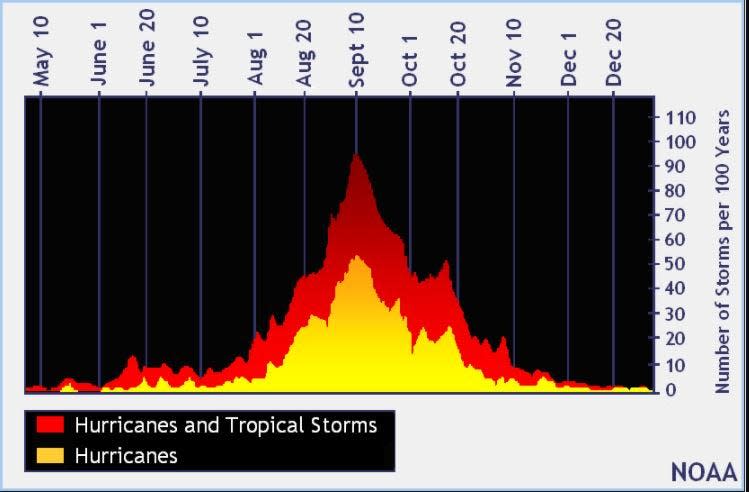
The peak of the season is Sept. 10, with the most activity happening between mid-August and mid-October, according to the Hurricane Center.
Tropical forecast over the next seven days
Excessive rainfall forecast
What's out there?
Systems currently being monitored by the National Hurricane Center.

Noaa
Embedded content: https://www.nhc.noaa.gov/xgtwo/two_atl_0d0.png?052051
What's next?
We will continue to update our tropical weather coverage daily. Download your local site's app to ensure you're always connected to the news. And look at our special subscription offers here.
Contributor: Doyle Rice, USA Today
This article originally appeared on Treasure Coast Newspapers: NHC: Tropical updates Philippe, Rina. Spaghetti models, forecast path

