National Hurricane Center tracking tropical wave expected to become depression soon
Former Tropical Storm Sean is now a remnant low as forecasters turn their eyes toward a developing system approaching the Caribbean, according to the latest advisory from the National Hurricane Center.
The National Hurricane Center issued its last advisory on Sean Sunday night. Winds were at 30 mph and it was expected to dissipate more today and Tuesday.
Invest 94L in the Central Atlantic is expected to become a tropical depression within a few days. If does become a named storm, it would be the 19th of the season, which is above the average of 14.
Tammy is the next name on the list of 2023 tropical storms.
Hurricane season 2023: No-name storm brings nasty weather to Florida; cold fronts could chill hurricane season
AccuWeather predicted Invest 94L could take one of two paths as it moves across the Atlantic, all determined by an area of low pressure over the North Atlantic.
It could stay south and move toward the Lesser Antilles, or it could turn north and stay over open waters, according to AccuWeather.
If it does become a named storm, that leaves two names remaining on the 2023 list of storms: Vince and Whitney. Hurricane season doesn't end until Nov. 30, although storms can and do form any time.
Here's the latest update from the NHC as of 2 p.m.:
What is out there and how likely is it to strengthen?
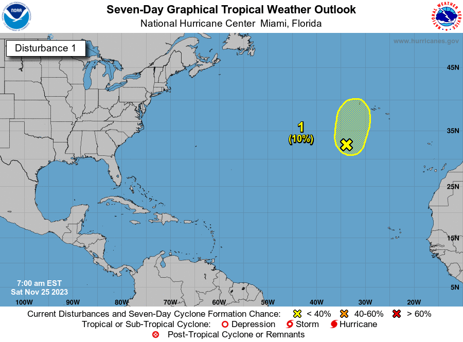
Invest 94L: A broad area of low pressure located over the central tropical Atlantic about midway between the Windward Islands and western Africa is producing a large area of disorganized showers and thunderstorms.
Satellite data indicate that the low-level circulation continues to become better defined and, since environmental conditions are expected to remain conducive for further development, a tropical depression is likely to form within a few days.
This system is forecast to move westward to west-northwestward across the central and western tropical Atlantic during the next several days.
Formation chance through 48 hours: medium, 40 percent.
Formation chance through 7 days: high, 80 percent.
Spaghetti models for Invest 94L
Special note about spaghetti models: Illustrations include an array of forecast tools and models, and not all are created equal. The hurricane center uses only the top four or five highest performing models to help make its forecasts.
Who is likely to be impacted?
No impacts to Florida or the rest of the U.S. are expected at this time from Invest 94L.
Forecasters urge all residents to continue monitoring the tropics and to always be prepared.
Weather watches and warnings issued in Florida
When is the Atlantic hurricane season?
The Atlantic hurricane season runs from June 1 through Nov. 30.
When is the peak of hurricane season?
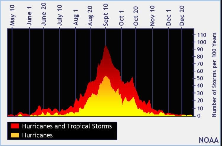
The peak of the season is Sept. 10, with the most activity happening between mid-August and mid-October, according to the Hurricane Center.
Tropical forecast over the next seven days
Excessive rainfall forecast
What's out there?
Systems currently being monitored by the National Hurricane Center.

Noaa
Embedded content: https://www.nhc.noaa.gov/xgtwo/two_atl_0d0.png?052051
What's next?
We will continue to update our tropical weather coverage daily. Download your local site's app to ensure you're always connected to the news. And look at our special subscription offers here.
This article originally appeared on Treasure Coast Newspapers: NHC tracking Invest94L. Tropical depression likely. Tammy next name
