National Hurricane Center tracking Invest 95L. Tropical depression possible in coming days
An area of low pressure in the central tropical Atlantic has a good chance of developing into a tropical depression over the next few days, according to the National Hurricane Center.
Chances have increased to 60 percent for the system — currently designated Invest 95L — to become a tropical depression early next week, according to the latest advisory.
A slow westward track puts it near the Leeward Islands early next week. While it's too soon to talk about threats to the U.S., Florida residents are advised to stay informed, said the Florida Public Radio Emergency Network.
If it becomes a named storm, it would be Emily.
An area of low pressure in the central tropic Atlantic has a good chance to develop into Tropical Depression Emily the next few days. A slow westward track puts it near the Leeward Islands early next week. Too soon to talk threats for U.S. mainland but keep watching with us. pic.twitter.com/VifInxX8EV
— Florida Storms (@FloridaStorms) July 21, 2023
Chances have increased to 60 percent for development over the next seven days, according to the latest advisory from the National Hurricane Center. The system is moving toward the Caribbean.
Elsewhere, Tropical Storm Don has strengthened slightly but continues to spin in the Central Atlantic, and is expected to weaken by Sunday. It is not expected to impact land.
Latest hurricane season forecast: What deranged heat and sea temps tell us about hurricane season
Elsewhere in the tropics, forecasters are keeping an eye on two tropical waves, including one in the Caribbean.
July to early August is typically a quiet time for tropical activity in the Atlantic. Dry air and wind shear help inhibit the development of tropical cyclones. Both those conditions are showing signs of disappearing, according to AccuWeather.
Waters are incredibly warm in the Caribbean and surrounding much of Florida, ranging from the mid-80s to near 90, with pockets of even warmer conditions.
Any disturbance that wanders over the warm water, provided wind shear is low and the air is moist, has a chance of ramping up.
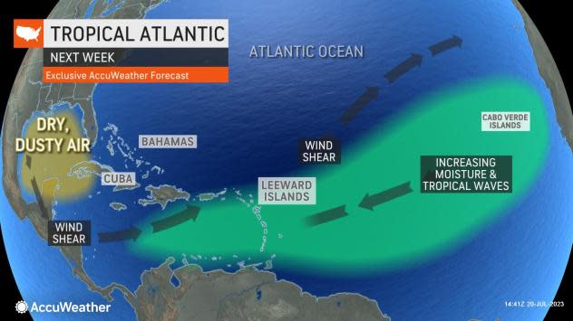
"One such tropical wave may be in a better spot for development from the northern islands of the Caribbean to Florida and the Bahamas during the first few days of August," said AccuWeather Lead Long-Range Meteorologist Paul Pastelok.
"Long-range data suggests that a weak system, such as a depression or storm with drenching rain, is not totally out of the question in waters surrounding the islands to Florida in early August," he added.
Here's the latest update from the NHC as of 2 p.m. July 21:
Tropical Storm Don

Location: 755 miles south-southeast of Cape Race, Newfoundland
Maximum wind speed: 60 mph
Direction: northwest at 12 mph
What's out there and where are they?
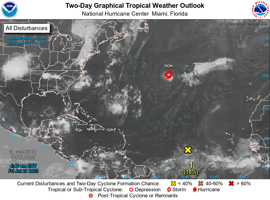
Tropical Storm Don: At 5 p.m., the center of Tropical Storm Don was located 755 miles south-southeast of Cape Race, Newfoundland. Exact location: near latitude 36.6 North, longitude 47.5 West.
Invest 95L: A small area of low pressure, located several hundred miles west-southwest of the Cabo Verde Islands, is producing an area of disorganized showers and thunderstorms over the central tropical Atlantic.
Tropical wave 2: A tropical wave in the eastern Atlantic is located northwest of Cabo Verde. It's moving west at 11 mph. Exact location: near 31W from 19N southward.
Tropical wave 3: A tropical wave in the central Caribbean is located between Jamaica and Haiti. It's moving west at 17 to 23 mph. Exact location: near 75W from southwest of Haiti near 17N southward into northwestern Colombia.
How likely is Tropical Storm Don to strengthen?
Maximum sustained winds have increased to near 60 mph, with higher gusts. Some slight strengthening is possible Friday night or Saturday. Weakening is forecast to begin by Saturday night, and Don is expected to become a post-tropical cyclone on Sunday.
Tropical-storm-force winds extend outward up to 60 miles from the center.
What are the chances of Invest 95L strengthening?
Although there is dry air located to the north of the system, favorable upper-level winds are expected to allow for gradual development during the next several days. This system could become a tropical depression early next week, as it moves westward across the tropical Atlantic.
Formation chance through 48 hours: medium, 40 percent.
Formation chance through 7 days: medium, 60 percent.
Who is likely to be impacted?
No impact to land is expected from Tropical Storm Don.
It's too early at this time to determine if there will be any impact to the U.S. from the tropical waves.
Forecasters urge all residents to continue monitoring the tropics and to always be prepared.
Weather watches and warnings issued in Florida
If you can't see any local weather warnings here, you'll need to open this story in a web browser.
When is the Atlantic hurricane season?
The Atlantic hurricane season runs from June 1 through Nov. 30.
When is the peak of hurricane season?

The peak of the season is Sept. 10, with the most activity happening between mid-August and mid-October, according to the Hurricane Center.
Tropical forecast over the next seven days
Excessive rainfall forecast
What's out there?
Systems currently being monitored by the National Hurricane Center.

What's next?
We will continue to update our tropical weather coverage daily. Download your local site's app to ensure you're always connected to the news. And look at our special subscription offers here.
This article originally appeared on Palm Beach Post: NHC tracking Invest 95L with 60 percent chance of development

