National Hurricane Center tracking Tropical Storm Philippe, Invest 91L. See spaghetti models
As forecasters keep a close eye for a "homebrew" tropical system, the National Hurricane Center continues to track two tropical disturbances in the Atlantic: Tropical Storm Philippe and Invest 91L.
A "homebrew" system is one that develops close to the U.S.
Philippe was a little stronger this morning, with winds increasing to 50 mph, but the tropical storm is expected to weaken over the next several days.
Tropical Storm Philippe's path has shifted more toward the west, with the latest forecast calling for it to move toward Puerto Rico and Hispaniola.
Invest 91L is expected to strengthen into a tropical depression or storm in the next day as it moves west-northwest across the central tropical Atlantic.
The next name in the Atlantic hurricane season is Rina.
We're currently in the middle of the busiest period of the Atlantic hurricane season. The season runs from June 1 through Nov. 30, with the most-active period running from mid-August through mid-October.
What impact could Philippe and Invest 91L have on Florida?
Tropical Storm #Philippe is expected to fizzle before entering the Caribbean. INVEST-91 will likely be a depression soon but tropical models are turning it northward later this week. So no immediate threats for us but please stay pugged in! pic.twitter.com/ld0tUhZvhm
— Florida Storms (@FloridaStorms) September 26, 2023
Tropical Storm Philippe "poses no direct threat to Florida over the next 5-7 days, at least," according to the Florida Division of Emergency Management.
The Florida Division of Emergency Management also said Invest 91L "poses no direct threat to Florida at this time."
That doesn't mean Florida will see clear skies this week.
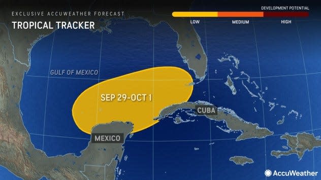
AccuWeather forecasters said they're closely watching a zone from the northwestern Caribbean to the southeastern Gulf of Mexico and Atlantic waters just east of Florida for tropical development from the end of September to early October.
"Even if a named storm does not form, tropical moisture from the region could continue to fuel downpours and thunderstorms in part of the Southeast in the coming days," according to AccuWeather.
"The weather setup will also lead to coastal hazards all along the Eastern Seaboard, regardless of whether an organized system develops."
"The area where a tropical system may slowly take shape this week is located just south of a stalled front left behind in the wake of Ophelia," AccuWeather Chief On-Air Meteorologist Bernie Rayno said. "Stalled fronts near the southeastern U.S. are potential formation areas for homebrew tropical systems."
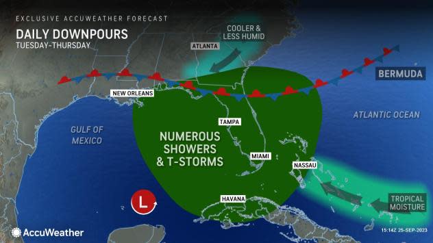
So what can Florida expect this week? Clusters of showers and thunderstorms from Florida to much of the northern Gulf coast of the U.S., according to AccuWeather.
West Palm Beach set a daily rainfall record Tuesday, receiving 3.43 inches of rain, according to the National Weather Service Miami. The previous record was 2.77 inches set in 1968.
Here's the latest update from the NHC as of 2 p.m. Wednesday:
Tropical Storm Philippe

Special note on the NHC cone: The forecast track shows the most likely path of the center of the storm. It does not illustrate the full width of the storm or its impacts, and the center of the storm is likely to travel outside the cone up to 33% of the time.
Location: 620 miles east of the northern Leeward Islands; 1,798 miles east of West Palm Beach
Maximum wind speed: 50 mph
Direction: west at 9 mph
At 11 a.m., the center of Tropical Storm Philippe was located near latitude 17.5 North, longitude 53.7 West. Philippe is moving toward the west near 9 mph, and a westward to west-northwestward motion is expected over the next few days.
Maximum sustained winds have increased to near 50 mph, with higher gusts. Little change in strength is forecast the next day or two, with slow weakening forecast this weekend.
Tropical-storm-force winds extend outward up to 205 miles from the center.
The estimated minimum central pressure is 998 mb.
Forecast Path: Spaghetti models for Philippe
Special note about spaghetti models: Illustrations include an array of forecast tools and models, and not all are created equal. The hurricane center uses only the top four or five highest performing models to help make its forecasts.
What else is out there and how likely are they to strengthen?

Invest 91L: Showers and thunderstorms have not become any better organized in association with an area of low pressure located roughly halfway between the Cabo Verde Islands and the Lesser Antilles.
Environmental conditions are forecast to be conducive for development, and a tropical depression or storm is expected to form in the next day or so while the system moves west-northwestward across the central tropical Atlantic.
➤ Spaghetti models for Invest 91L
Formation chance through 48 hours: high, 90 percent.
Formation chance through seven days: high, 90 percent.
Who is likely to be impacted?
It's too early at this time to determine if there will be any impact to the U.S. from Invest 91L or Tropical Storm Philippe.
Philippe is forecast to produce 2 to 4 inches of rain across the northern Leeward Islands, the Virgin Islands, and eastern Puerto Rico Friday through Monday. Across western Puerto Rico, 1 to 2 inches of rain is expected.
Forecasters urge all residents to continue monitoring the tropics and to always be prepared.
Weather watches and warnings issued in Florida
When is the Atlantic hurricane season?
The Atlantic hurricane season runs from June 1 through Nov. 30.
When is the peak of hurricane season?
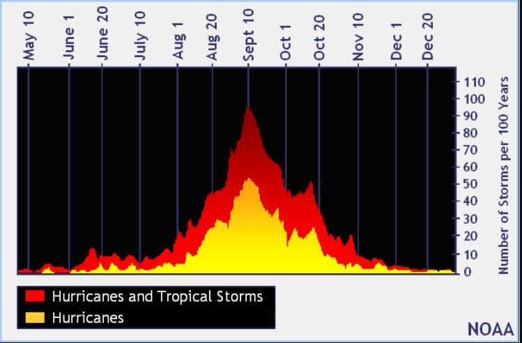
The peak of the season is Sept. 10, with the most activity happening between mid-August and mid-October, according to the Hurricane Center.
Tropical forecast over the next seven days
Excessive rainfall forecast
What's out there?
Systems currently being monitored by the National Hurricane Center.

Noaa
Embedded content: https://www.nhc.noaa.gov/xgtwo/two_atl_0d0.png?052051
What's next?
We will continue to update our tropical weather coverage daily. Download your local site's app to ensure you're always connected to the news. And look at our special subscription offers here.
This article originally appeared on Treasure Coast Newspapers: NHC tracking Tropical Storm Philippe. Invest 91L expected strengthen

