National Hurricane Center tracking tropical depression expected to become hurricane soon
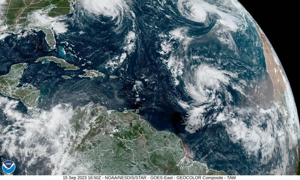
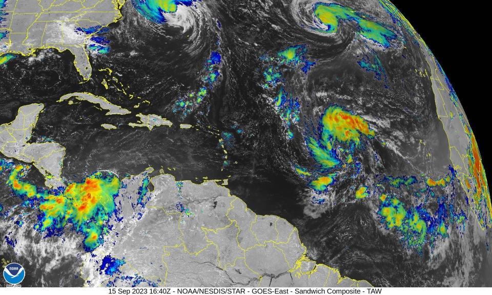
Tropical Depression 15 formed in the central Atlantic late Friday and is expected to quickly strengthen as it moves toward the northwest, according to the latest advisory from the National Hurricane Center.
The depression is forecast to become a tropical storm Saturday and could become a hurricane late this weekend.
The developing storm will likely be named Nigel, unless something else pops up very soon ahead of it to grab the next name on this year's list.
The storm popped up in the central Atlantic as residents along the east coast of the U.S. brace for Hurricane Lee, expected to make landfall in New England or Atlantic Canada this weekend.
Tropical Depression 15 expected to become Nigel
Newly formed #TD15 is forecasted to become the next major hurricane and it may be headed near Bermuda by late next week. Beyond that, a recurve appears likely given all the recent ensemble data. Will keep watching nevertheless. pic.twitter.com/hfA6LNpXSo
— Hurricane Tracker App (@hurrtrackerapp) September 15, 2023
The National Hurricane Center is predicting Tropical Depression 15 will become a tropical storm Saturday and a hurricane late this weekend.
Nigel is the next name on the list for the 2023 Atlantic hurricane season.
Nigel could follow in Hurricane Lee's footsteps
The storm could follow a path similar to that Hurricane Lee's over the past week, according to AccuWeather.
As of Friday afternoon, Lee was approaching eastern New England and Atlantic Canada and was forecast to make landfall over the weekend.
Will Nigel become season's next major hurricane?
The National Hurricane Center is predicting maximum sustained winds could reach 120 mph in four days, making it a Category 3 storm. And that's a conservative estimate, forecasters said.
A major hurricane is one where maximum sustained winds are at least 111 mph, the minimum to be classified as a Category 3 hurricane. Major hurricanes are Category 3, 4 and 5 storms.
"By early next week, this system is forecast to move over near record warm sea-surface temperatures for the region in light (wind) shear conditions.
"It probably sounds like a broken record at this point in the season, but rapid intensification is a significant possibility," NHC forecasters said.
"With the next storm potentially tracking over deep warm water, it's not out of the question it can become another major hurricane and perhaps even a Category 5 storm," AccuWeather Hurricane Expert Dan Kottlowski said.
Forecast path: Where is Tropical Depression 15 and where is it going?

Special note on the NHC cone: The forecast track shows the most likely path of the center of the storm. It does not illustrate the full width of the storm or its impacts, and the center of the storm is likely to travel outside the cone up to 33% of the time.
Location: 1,150 miles east of the Lesser Antilles
Maximum sustained winds: 35 mph
Movement: northwest at 13 mph
At 5 p.m., the center of Tropical Depression 15 was located near latitude 15.4 North, longitude 44.0 West. The depression is moving toward the northwest near 13 mph, and this general motion is expected to continue for the next few days.
Maximum sustained winds are near 35 mph, with higher gusts.
Gradual strengthening is forecast, but a faster rate of intensification is predicted later this weekend and early next week. The depression is forecast to become a tropical storm Saturday and could become a hurricane late this weekend or early next week.
The estimated minimum central pressure is 1007 mb.
Spaghetti models for Tropical Depression 15
Special note about spaghetti models: Illustrations include an array of forecast tools and models, and not all are created equal. The hurricane center uses only the top four or five highest performing models to help make its forecasts.
Tropical Depression 15 could become Category 3 storm in 4 days
Rapid intensification is a significant possibility, and the official forecast could be conservative, NHC forecasters said.
12 hours: 35 mph
24 hours: 45 mph (tropical storm)
36 hours: 60 mph
48 hours: 70 mph
60 hours: 80 mph (Category 1)
72 hours: 100 mph (Category 2)
96 hours: 115 mph (Category 3)
120 hours: 115 mph
What could affect where Tropical Depression 15 goes?
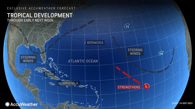
There is still some long-range uncertainty in how far west this system will go, which partially depends on the strength of a subtropical ridge in the wake of Tropical Storm Margot.
“This next system is one to watch as a potential threat to the East Coast of the United States given how strong the Bermuda high-pressure area will be as it builds westward across the Atlantic," said Kottlowski.
"With that and the upper-level wind pattern factored in, we could see this storm coming toward the United States."
The location of a system of high pressure over the open northern Atlantic helped determine where Lee went this week, and the same will be the case for the next storm. Another determining factor will be any potential cold fronts moving off the coast of the eastern United States, AccuWeather forecasters explained.
There appear to be two possible scenarios later next week for what may become Nigel: a track more out to sea or one toward the East Coast.
If the area of high pressure is stronger and builds more toward the northeastern U.S., steering winds can pull the storm closer to the East Coast.
If the high doesn’t build toward the Northeast and is weaker, the storm will tend to steer close to Bermuda or perhaps even farther to the east and out to sea, according to AccuWeather.
Impacts expected: Who should keep an eye on Tropical Depression 15?
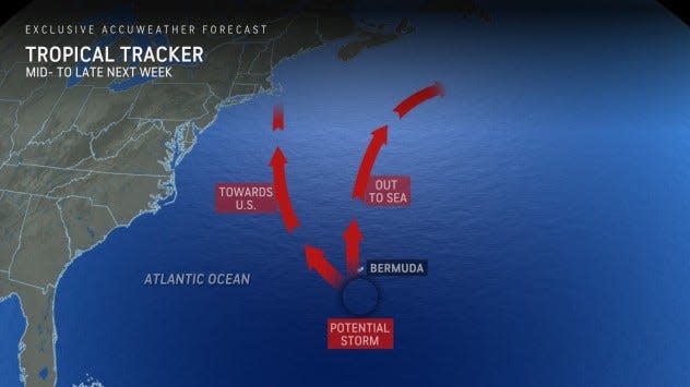
Because the expected path of the new storm and its risk for strengthening could mirror Lee, residents along the East Coast of the U.S., Bermuda and southeastern Canada should monitor it closely, AccuWeather forecasters said.
"Direct or indirect impacts could begin as early as the middle of next week."
Regardless of the final destination with the next storm, indirect impacts may be felt from the Bahamas to Bermuda and along the entire U.S. East Coast into Atlantic Canada.
Residents could see dangerous waves and rip currents.
This article originally appeared on Treasure Coast Newspapers: Tropical Depression 15 expected to become Tropical Storm Nigel soon

