National Hurricane Center tracking two disturbances in Atlantic and two tropical waves
The National Hurricane Center is tracking two disturbances in the Atlantic and two tropical waves, according to the latest advisory.
Chances for the remnants of former Tropical Storm Cindy to strengthen are dropping but impacts are still expected in Bermuda and eastern Canada.
A new disturbance south-southeast of Bermuda — the remnants of Cindy are located south-southwest of the islands — appeared on the Hurricane Center's tropical outlook map this morning. It currently has a low chance for development as it moves north well off the coast of the U.S.
In the Pacific, the first named storm of that season developed Tuesday afternoon, Tropical Storm Adrian. A second storm is forecast to develop later in the week west of Central America.
"Up to this point, Cindy has largely been a non-factor in terms of overall impacts to land. However, that is expected to change in the later stages of this week into the weekend," said AccuWeather Meteorologist La Troy Thornton.
Tropical Rainstorm Cindy is first expected to track near the islands of Bermuda around the middle of the week, according to AccuWeather.
Atlantic water temperatures remain very warm, which helps the development of tropical cyclones, but strong wind shear is helping tear apart anything trying to develop.
The combination is likely to prevent the formation of any new named storms across the Atlantic this week, which is typical for this time of year, according to AccuWeather.
The next named storm of the Atlantic hurricane season will be Don.
Will El Niño calm the tropics? 2023 hurricane season is unlike any other with forecasters putting all faith in El Niño
Here's the latest update from the NHC as of 8 a.m. June 28:
What's out there and where are they?
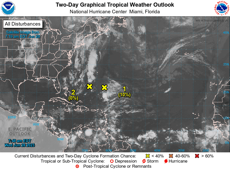
Tropical Storm Cindy remnants (Disturbance 2): A weak trough of low pressure, associated with the remnants of Cindy and located about 400 miles south-southwest of Bermuda, is producing disorganized showers.
Disturbance 1: An area of disturbed weather, associated with a system of low pressure, has formed about 400 miles south-southeast of Bermuda.
Tropical wave 1: A tropical wave in the central Atlantic is located between Cabo Verde and St. Lucia. It's moving west at 13 mph. Exact location: near 37W from 02N to 15N.
Tropical wave 2: A tropical wave in the eastern Caribbean is located east of Puerto Rico. It's moving west at 18 mph. Exact location: near 65W, S of 18N to inland Venezuela.
How likely are the remnants of Tropical Storm Cindy to strengthen?
This system is expected to drift toward the west-northwest during the next couple of days, and redevelopment is not expected due to strong upper-level winds.
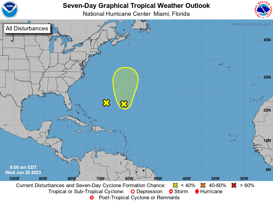
Formation chance through 48 hours: low, near 0 percent.
Formation chance through 7 days: low, near 0 percent.
Chances for development of disturbance southeast of Bermuda
Upper-level winds are marginally conducive for some slow development of this system during the next few days while it moves generally north at about 5 mph.
Formation chance through 48 hours: low, 10 percent.
Formation chance through 7 days: low, 20 percent.
Who is likely to be impacted?
Remnants of Tropical Storm Cindy: Forecasts call for the center of the storm to move north and pass just to the west of Bermuda. AccuWeather meteorologists are forecasting 1 to 2 inches of rain for the islands with 3 inches in some locations.
"Most of the rain will fall from Wednesday to Wednesday night," AccuWeather Senior Meteorologist Alex Sosnowski said. "Thursday may bring gusty winds and sporadic showers along with rough seas about the islands."
The tropical rainstorm is expected to approach eastern parts of Nova Scotia from Friday to Saturday, bringing with it rounds of heavy, tropical rainfall.
It's too early at this time to determine if there will be any impact to the U.S. from the other disturbance in the Atlantic or the tropical waves.
Forecasters urge all residents to continue monitoring the tropics and to always be prepared.
NOAA hurricane season prediction: NOAA predicts 'near normal' hurricane season with 12-17 named storms and 5-9 hurricanes
Weather watches and warnings issued for your area
If you can't see any local weather warnings here, you'll need to open this story in a web browser.
When is the Atlantic hurricane season?
The Atlantic hurricane season runs from June 1 through Nov. 30.
When is the peak of hurricane season?
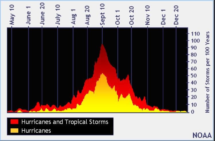
The peak of the season is Sept. 10, with the most activity happening between mid-August and mid-October, according to the Hurricane Center.
Tropical forecast over the next seven days
Excessive rainfall forecast
What's out there?
Systems currently being monitored by the National Hurricane Center.
What's next?
We will continue to update our tropical weather coverage daily. Download your local site's app to ensure you're always connected to the news. And look at our special subscription offers here.
This article originally appeared on Treasure Coast Newspapers: NHC tracking 2 tropical disturbances in Atlantic, 2 tropical waves

