National Hurricane Center tracking a wave expected to become tropical depression
Philippe is now a post-tropical cyclone, but it is still expected to bring heavy rain, winds and flooding to New England and Atlantic Canada this weekend.
The National Hurricane Center is following three tropical waves farther south, including one that is expected to become a tropical depression.
AccuWeather is predicting Philippe to make landfall in Maine early Sunday morning and bring flash flooding and coastal flooding to the region. It will move to the south and east of Cape Cod, Massachusetts, on Saturday at 15-20 mph, according to AccuWeather.
Residents in those areas should "be prepared for the possibility of strong winds and heavy rainfall and monitor statements from their local weather office," NHC forecasters said. Because Philippe is post-tropical, NHC is longer longer providing updates on its projected path.
AccuWeather said Philippe is not expected to have the same impact on New England and Canada as Lee did three weeks ago, when more than 200,000 customers in Nova Scotia lost power.
A broad range of winds ranging from 40-60 mph are expected from northeastern Maine through much of the Gulf of St. Lawrence in Canada, AccuWeather said.
Florida hurricane season outlook: Landfall free September leads to October uncertainty
Meanwhile, conditions for development on the tropical wave over the coast of Senegal are expected to be conducive for development. The storm is expected to become a tropical depression by the middle of next week.
The next three named storms would be Rina, Sean and Tammy.
Here's the latest update from the NHC as of 8 a.m.:
What's out there and where are they?
Disturbance 1: A tropical wave along the west coast of Africa is estimated to be moving near 11 mph off the coast of St. Louis, Senegal. Scattered moderate to strong convection is noted from 5N to 10N between 13W and 20W. Exact location: along 17W, south of 16N.
Tropical wave 1: A complex tropical wave is analyzed from east of French Guiana to the central tropical Atlantic, moving west at 11-17 mph. Scattered showers are noted from 8N to 16N between 40W and 47W. Further east, satellite imagery and precipitable water products show distinct cyclonic turning along 34W. Scattered moderate to strong convection is about this circulation from 7N to 12.5N between 33W and 39W. Exact location: along 43W, from 6N to 17N.
Tropical wave 2: A tropical wave is analyzed across the central Caribbean north of the Dominican Republic, moving west at 11-17 mph. Scattered showers and a few small thunderstorms dot the waters of the Caribbean north of 14N to Hispaniola between 68W and 73.5W. Satellite imagery and precipitable water products show cyclonic turning along 68W. Scattered to locally numerous moderate to strong convection is noted from 11N to 14N between 61W and 69W. Exact location: 71.5W, south of 20N.
How likely are they to strengthen?
Disturbance 1: A low-latitude tropical wave located near the west coast of Africa continues to produce a large area of disorganized showers and thunderstorms. Environmental conditions appear conducive for gradual development, and a tropical depression is likely to form by the early to middle part of next week while it moves west to west-northwest across the eastern tropical Atlantic.
Formation chance through 48 hours: low, 20 percent.
Formation chance through seven days: high, 70 percent.
Who is likely to be impacted?
It's too early at this time to determine if there will be any impact to the U.S. from the tropical waves.
Forecasters urge all residents to continue monitoring the tropics and to always be prepared.
Weather watches and warnings issued in Florida
When is the Atlantic hurricane season?
The Atlantic hurricane season runs from June 1 through Nov. 30.
When is the peak of hurricane season?
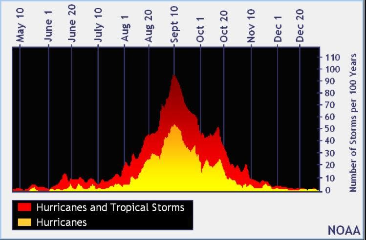
The peak of the season is Sept. 10, with the most activity happening between mid-August and mid-October, according to the Hurricane Center.
Tropical forecast over the next seven days
Excessive rainfall forecast
What's out there?
Systems currently being monitored by the National Hurricane Center.

Noaa
Embedded content: https://www.nhc.noaa.gov/xgtwo/two_atl_0d0.png?052051
What's next?
We will continue to update our tropical weather coverage daily. Download your local site's app to ensure you're always connected to the news. And look at our special subscription offers here.
This article originally appeared on Treasure Coast Newspapers: NHC tracking tropical wave as Philippe heads to Maine: See forecasts

