National Hurricane Center tracks Hurricane Tammy; new storm system. See latest spaghetti models
Hurricane Tammy was pulling away from the northernmost Leeward Islands Sunday morning and was expected to make a northern turn and move slowly north-northeastward into the beginning of next week, according to the National Weather Service.
Hurricane and tropical storm warnings were discontinued as of the National Hurricane Center's 8 a.m. advisory, and no new ones were put into effect.
Tammy is a Category 1 storm with maximum sustained winds of 80 mph. As of the National Hurricane Center's 11 a.m. EDT advisory, on the forecast track, the center of Tammy is expected to0 move north of the northern Leeward Islands.
The National Hurricane Center was also tracking a tropical disturbance in the southwestern Caribbean with a medium chance of developing this week.
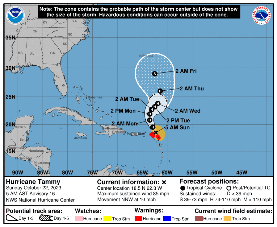
Cone of uncertainty: See the latest graphic from the NHC
Satellite images: See latest satellite image from NOAA, for a clearer picture of the storm's size
According to USA TODAY Network data, the storm's center was located about 60 miles northeast of Anguilla. The storm's center was located about 1,200 miles southeast of West Palm Beach, Florida.
The latest NHC advisory says Tammy's path is moving toward the north-northwest near 9 mph.
Expected impacts from Hurricane Tammy
The advisory warns of the following dangers:
WIND: Hurricane conditions are expected over portions of the northern Leeward Islands through this morning. Tropical storm conditions are expected within the tropical storm warning areas through this morning.
RAINFALL: Tammy is expected to produce the following storm total rainfall:Leeward Islands: 4 to 8 inches with storm total maximum amounts of 12 inchesMartinique and Dominica: Additional 2 to 4 inches, storm total maximum 6 inches. British and U.S. Virgin Islands into eastern Puerto Rico: 1 to 2 inches with maximum storm total amounts of 4 inches. These rains may produce isolated flash and urban flooding, along with isolated mudslides in areas of higher terrain.
STORM SURGE: Storm surge could raise water levels by as much as 1 to 3 feet above normal tide levels near where the center of Tammy moves across the Leeward Islands. Near the coast, the surge will be accompanied by large and dangerous waves.
SURF: Swells generated by Tammy will continue to affect portions of the Lesser Antilles during the next few days. These swells are likely to cause life-threatening surf and rip current conditions. Please consult products from your local weather office.
Where is Hurricane Tammy?
Here are the latest details on Tammy, according to the NHC's 5 a.m. advisory.
Location: 60 miles north of Anguilla. The storm's center was located about 1,200 miles southeast of West Palm Beach, Florida.
Maximum sustained winds: 80 mph
Movement: North northwest at 9 mph
Minimum central pressure: 992 mb
Anything greater than 979 MB is one indicator a storm could cause minimal damage. According to the NHC, the minimum central pressure of a storm is not necessarily a hazard, but it could indicate whether a storm will intensify in the future. Strengthening usually follows a drop in pressure, and a weakening usually follows an increase in pressure.
What does the cone of uncertainty represent?
The cone of uncertainty, posted by the NHC, shows some possible paths of the storm's center. As you monitor the forecast, keep in mind that the impact of Tammy may be felt well outside the cone - and that storm tracks go outside of the cone about a third of the time.
Watches, warnings
Hurricane warnings for Hurricane Tammy
All hurricane warnings were lifted as of the NHC's 8 a.m. advisory.
A Hurricane Warning means that hurricane conditions are expected somewhere within the warning area, in this case over the next few hours.
Tropical storm warnings for Hurricane Tammy
All tropical storm warnings were lifted as of the NHC's 8 a.m. advisory
A Tropical Storm Warning means that tropical storm conditions are expected somewhere within the warning area, in this case over the next few hours.
Spaghetti models for Hurricane Tammy's track
This auto-updated graphic shows how various spaghetti models are tracking Hurricane Tammy:
If the storm tracker is not not loading, click here.
Special note about spaghetti models: Illustrations include an array of forecast tools and models, and not all are created equal. The hurricane center uses only the top four or five highest performing models to help make its forecasts.
Who is likely to be impacted from Hurricane Tammy?
No impacts to Florida or the rest of the U.S. are expected at this time from Hurricane Tammy.
What other storm systems are in the Atlantic and Gulf on Sunday?
Showers and thunderstorms have become better organized in association with a low-pressure system located over the southwestern Caribbean Sea, NHC forecasters said at 8 a.m.
Gradual development of this system is possible, and a tropical depression could form before the system moves inland over Nicaragua by early Tuesday. This system could produce heavy rains over portions of Central America during the next couple of days.
Formation chance through 48 hours: 50 percent
Formation chance through 7 days: 50 percent
When does the Atlantic hurricane season end?
The Atlantic hurricane season starts June 1 and ends Nov. 30.
When is the peak of hurricane season?
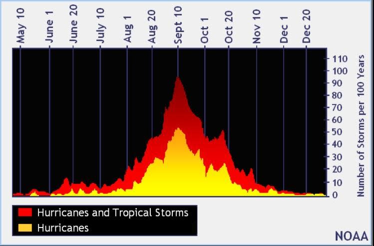
The peak of the season is Sept. 10, with the most activity happening between mid-August and mid-October, according to the Hurricane Center.
What are the 2023 hurricane names?
These are 2023 hurricane names. There are only two more names remaining before an alternative names list will be used.
Arlene
Bret
Cindy
Don
Emily
Franklin
Gert
Harold
Idalia
Jose
Katia
Lee
Margot
Nigel
Ophelia
Philippe
Rina
Sean
Tammy
Vince
Whitney
Helpful hurricane resources and links
Get your home ready: Here is how to prepare your home for a hurricane, from well in advance to just before a storm's arrival
Need to prepare for a hurricane? Here is what you should have in a disaster supply kit
Hurricane preparedness list: If a storm is coming, here is what you need to do now
Hurricanes, typhoons, and cyclones: What's an invest and why do they keep saying tropical cyclone?
Officials encourage residents to assemble a hurricane kit early, storing enough supplies to last at least three days. Doing so ensures there are adequate supplies available on store shelves and prevents a rush - and shortages - that regularly occur when a storm is imminent.
This article originally appeared on The Daytona Beach News-Journal: Hurricane Tammy Sunday storm impacts in Caribbean and Florida

