National Hurricane Center watching 4 tropical waves as cold front breaks Florida records
As the season's first strong cold front moved south, the National Hurricane Center continues to keep an eye open for potential tropical activity in the Atlantic basin.
Temperatures early Thursday morning ranged from the low to mid-30s in Florida's Panhandle to the mid and upper 60s in the Keys, according to the National Weather Service, Miami.
Several record low temperatures around the state were either broken or tied Wednesday as the front moved into the Gulf of Mexico.
The National Weather Service in Tallahassee reported several record low temperatures were broken Wednesday.
WOW! Every east central Florida climate site tied or broke the record cool maximum for today!
Daytona Beach: 68F (Tied)
Fort Pierce: 73F (Tied)
Leesburg: 67F (Prev 72F)
Melbourne: 70F (Prev 73F)
Orlando: 70F (Prev 71F)
Sanford: 69F (Prev 70F)
Vero Beach 73F (Prev 74F)— NWS Melbourne (@NWSMelbourne) October 20, 2022
Tallahassee reported a record low of 33, breaking a long-time record of 36 set in 1927.
Apalachicola temperatures dropped to 39, shattering the old record of 43 set in 2009.
Near record lows were reported in North Florida Thursday morning, according to the National Weather Service, Jacksonville. Inland locations reported temperatures in the 30s, including 34 at Live Oak and Jacksonville's Cecil Field.
In east-central Florida, seven cities tied or broke records, according to the National Weather Service, Melbourne.
Temperatures won't stay low for long.
AccuWeather forecasters said temperatures should rebound by 10 to 20 degrees across the eastern U.S. over the weekend and into early next week.
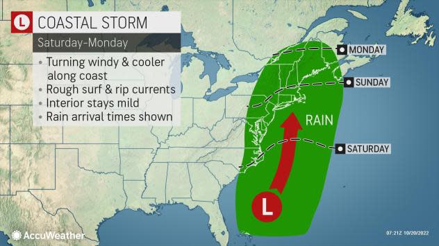
Another factor affecting weather into next week is a tropical rainstorm that could develop off the East Coast of the U.S. over the weekend.
The storm could bring rain, wind and rough surf conditions from eastern North Carolina to New England.
"If the storm develops to its full potential, it could generate heavy rain and urban flooding across the Interstate 95 corridor of the Northeast, along with strong winds that lead to coastal flooding later Sunday night into Monday,” said AccuWeather Senior Meteorologist Dean DeVore.► WeatherTiger: Florida Hurricane forecast: Amid Ian cone-troversy, season could see quiet conclusion
It's also not out of the realm of possibility the system could develop some tropical characteristics since it'll be forming over warm waters in the Gulf Stream.
A tropical depression or tropical storm could evolve, as a long shot, with a well-defined circulation and low-pressure center, AccuWeather said.
"There is a somewhat greater chance for the system to become a hybrid or subtropical system that has some tropical and some non-tropical aspects," said AccuWeather Senior Meteorologist John Gresiak.
A subtropical system has a poorly-defined center with pockets of dry air and gusty winds.
Elsewhere in the tropics, forecasters are keeping an eye on four tropical waves, three in the Atlantic Ocean and another in the Caribbean.
At this time of year, tropical cyclones typically form closer to the U.S. Earlier in the season sees storms moving across the Atlantic after emerging off the African coast.
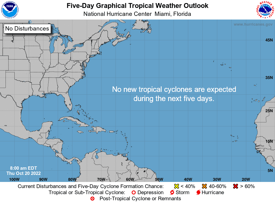
As of the latest advisory, the Hurricane Center said no tropical cyclones are expected over the next five days.
The next named storm of the season will be Lisa.
Ian's power left lasting damage: Photos reveal how Hurricane Ian flooded, pummeled and destroyed parts of Florida
'Cost for living in paradise.' After Hurricane Ian, will Florida residents build back better?
What the science says: Is climate change fueling massive hurricanes in the Atlantic?
Here's the latest update from the NHC as of 8 a.m. Oct. 20:
What's out there and where are they?
Tropical wave 1: An Atlantic Ocean tropical wave west of Cape Verde is moving west at 13 mph.
Tropical wave 2: A central Atlantic Ocean tropical wave is moving west at 8 mph.
Tropical wave 3: An Atlantic Ocean tropical wave east of the Leeward Islands is moving west around 8 mph.
Tropical wave 4: A Caribbean Sea tropical wave is moving west at 13 mph. This tropical wave passes through Honduras, Nicaragua, and Costa Rica.
Who is likely to be impacted?
It's too early at this time to determine if there will be any impact to the U.S. from the tropical waves.
Forecasters urge all residents to continue monitoring the tropics and to always be prepared during what's expected to be an active hurricane season.
When is the Atlantic hurricane season?
The Atlantic hurricane season runs from June 1 through Nov. 30.
When is the peak of hurricane season?

Although the season has gotten off to a quiet start, the peak of the season is Sept. 10, with the most activity happening between mid-August and mid-October, according to the Hurricane Center.
Weather watches and warnings issued for your area
If you can't see any local weather warnings here, you'll need to open this story in a web browser.
Tropical forecast over next five days
See the National Hurricane Center's five-day graphical tropical weather outlook below.
Excessive rainfall forecast
What's out there?
Systems currently being monitored by the National Hurricane Center.
What's next?
We will continue to update our tropical weather coverage daily. Download your local site's app to ensure you're always connected to the news. And look at our special subscription offers here.
This article originally appeared on Palm Beach Post: Tropics watch: NHC tracking 4 tropical waves. Tropical rainstorm forming

