National Hurricane Center watching 4 tropical waves, including 1 in Caribbean
The National Hurricane Center is showing no disturbances again this morning but it is tracking four tropical waves in the Atlantic basin, including one in the Caribbean.
No tropical cyclone development is expected over the next seven days.
AccuWeather meteorologists are tracking the potential for activity to increase in the western Caribbean and the Gulf of Mexico later this month, pointing to several factors — including warm waters in the Atlantic basin — that could foster tropical development.
Tropical development historically happens close to North America and Central America in June.

A large area of low pressure that develops annually over Central America can sometimes spawn tropical storms. As pressure drops in the system known as the Central America Gyre, thunderstorms develop. If they linger long enough, it may begin to rotate faster than the gyre, said AccuWeather.
Once the circulation is complete and winds increase to 35 mph, a tropical depression is born. If wind speeds increase to 39 mph or greater, a tropical storm will be named.
The next name for the 2023 Atlantic hurricane season will be Bret.
Here's the latest update from the NHC as of 8 a.m. June 14:
What's out there and where are they?

Tropical wave 1: A tropical wave in the eastern Atlantic is located south of Cabo Verde. It's moving west at 13 mph. Exact location: 23W and extending south from 12N.
Tropical wave 2: An Atlantic tropical wave in the central Atlantic is located between Cabo Verde and Trinidad and Tobago. It's moving west at 18 mph. Exact location: 38W and extending south from 11N.
Tropical wave 3: A tropical wave in the western Atlantic is located east of Barbados. It's moving west at 11 mph. Exact location: 56W and extending south from 13N.
Tropical wave 4: A tropical wave in the Caribbean Sea is located south of Haiti and immediately north of the South American coast. It's moving west at 13 mph. Exact location: 72W and extending south from 13N into northwestern Venezuela and eastern Colombia.
Hurricane season predictions up in air: Hurricane season 2023 forecast keeping meteorologists guessing | WeatherTiger
What is a tropical wave?
A tropical wave, also known as an easterly wave, is an elongated area of relatively low pressure that moves from east to west across the tropics. To the west of the system, there is often good weather. To the east, though, cloudiness and heavy rain are often found.
Tropical waves can lead to the formation of a tropical cyclone, according to NOAA.
Who is likely to be impacted?
It's too early at this time to determine if there will be any impact to the U.S. from the tropical waves.
However, as a train of tropical waves move across the Atlantic, there may be some tropical development in waters surrounding Central America and southern Mexico during the third week and fourth week of June, according to AccuWeather.
Forecasters urge all residents to continue monitoring the tropics and to always be prepared.
What is El Niño?
El Niño is a natural climate pattern in which surface sea water temperatures in the central and eastern tropical Pacific Ocean are warmer than average. It occurs, on average, every two to seven years.
Here's what the return of El Niño means for hurricane season and Florida
El Niño is a natural climate pattern in which surface sea water temperatures in the central and eastern tropical Pacific Ocean are warmer than average. It occurs, on average, every two to seven years.
El Niño usually helps to suppress Atlantic hurricane activity, experts say.
El Niño “tends to lead to an increase in vertical wind shear, which tends to reduce the number of hurricanes in the tropical Atlantic,” said David DeWitt, director of the Climate Prediction Center.
El Niño is back: NOAA says. Will it help fuel Earth's hottest year on record?
But this year, forecasters say that may not happen, because of record hot Atlantic water temperatures that would counteract the El Niño winds that normally decapitate many storms.
While El Niño can't completely prevent hurricanes in the Atlantic, it often serves to limit hurricane formation and reduce hurricane landfalls along the East Coast, giving Florida and other hurricane-prone areas a break.
NOAA hurricane season forecast: NOAA predicts 'near normal' hurricane season with 12-17 named storms and 5-9 hurricanes
Weather watches and warnings issued for your area
If you can't see any local weather warnings here, you'll need to open this story in a web browser.
When is the Atlantic hurricane season?
The Atlantic hurricane season runs from June 1 through Nov. 30.
When is the peak of hurricane season?
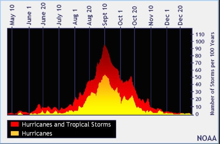
The peak of the season is Sept. 10, with the most activity happening between mid-August and mid-October, according to the Hurricane Center.
Tropical forecast over the next seven days
Excessive rainfall forecast
What's out there?
Systems currently being monitored by the National Hurricane Center.

What's next?
We will continue to update our tropical weather coverage daily. Download your local site's app to ensure you're always connected to the news. And look at our special subscription offers here.
Contributor: Doyle Rice
This article originally appeared on Tallahassee Democrat: Tropics watch: NHC tracking 4 tropical waves in Atlantic basin

