National Weather Service forecasts freezing rain, winter precipitation in area Thursday
The Thursday morning commute in the Interstate 81 corridor is expected to be messy with freezing rain the predominant precipitation expected, according to the National Weather Service.
The storm that has brought tornadoes and blizzards to other parts of the country this week also could impact the Thursday afternoon and Friday morning commutes.
The weather service issued an ice storm warning for Berkeley and Morgan counties in West Virginia for 10 p.m. Wednesday night through 10 p.m. Thursday, according to its website.
Winter weather advisories were issued for Washington and Frederick counties in Maryland; Jefferson County in West Virginia; and Franklin County in Pennsylvania. The advisories for Maryland and West Virginia are from 10 p.m. Wednesday through 4 p.m. Thursday, while the Pennsylvania advisory is for 1 a.m. to 7 p.m. Thursday.
More local news:Bowman Group temporary restraining order against truck stop ban denied; case continues
Meteorologist Austin Mansfield, with the Baltimore/Washington forecast office, advises residents and motorists to continue monitoring the forecast for updates and to "use extra caution" if they have to drive.
Keep as much distance as you can between other vehicles, Mansfield said.
In the Chambersburg, Pa., area and southern Franklin County, the storm could arrive as a light wintry mix and change to snow for a bit before becoming freezing rain, said meteorologist Rob Radzanowski with the State College forecast office.
"Just take it slow and be aware that there'll be a messy first half of the day," Radzanowski said. "Any road that's untreated is going to be slippery for the morning rush."
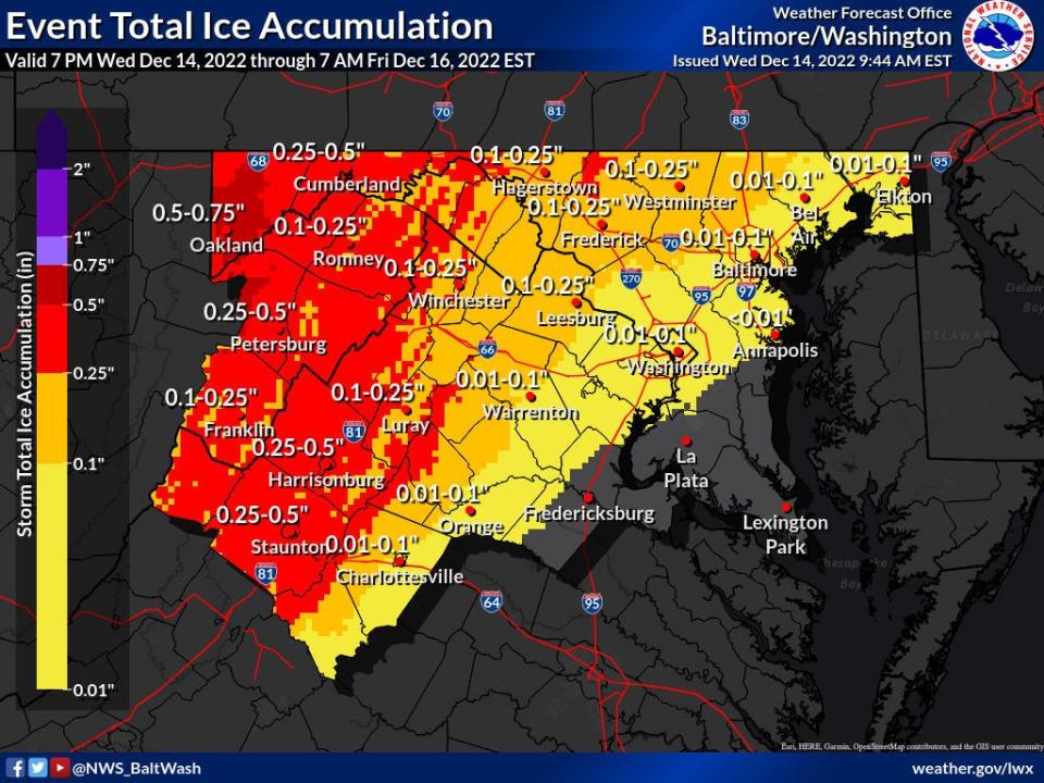
How much ice is expected?
The Washington and Frederick county areas could see 2/10 of an inch of freezing rain or slightly more, while Berkeley and Morgan counties could get closer to 3/10 of an inch, especially along higher ridge tops, Mansfield said.
The farther west, the higher the expected accumulation, he said. But conditions locally will still be "impactful."
South of the Mason-Dixon Line, there could be some sleet mixed in as the storm arrives, but it is expected to become mostly freezing rain. It's that freezing rain that could be heavier at times during the Thursday morning commute, Mansfield said.
Commuters on Thursday afternoon could see freezing rain or, later, cold rain depending on how late they are on the road, Mansfield said.
What about the Friday morning commute?
The precipitation is expected to wind down overnight Thursday into Friday morning as temperatures are expected to be just above freezing, Mansfield said. There could still be some local slick spots and conditions could change, he said.
In southern Franklin County, light rain changing back to snow showers is forecasted for the Friday morning commute, Radzanowski said.
This article originally appeared on The Herald-Mail: Freezing rain could bring mess Thursday to Chambersburg, Hagerstown

