National Weather Service tracking 3 systems, 1 from same zone as Ian
The tropical wave that might have become a tropical depression yesterday didn't, and probably isn't going to. A wave stretching from the central Caribbean is still disorganized and meandering. And now a new one coming from the same zone as Bonnie, Julia and Ian all did may strengthen by the end of the weekend.
The National Weather Service is tracking three tropical waves in the Atlantic and Caribbean, and while none of them show immediate signs of becoming anything more dangerous there is a chance the new one could develop into a tropical storm and bears watching.
"At this time, the risk of tropical development of the Caribbean system is low, but that could change over time," AccuWeather Senior Meteorologist Adam Douty said.
► WeatherTiger: Florida Hurricane forecast: Amid Ian cone-troversy, season could see quiet conclusion
Meanwhile, a cold front extending from the northwest Florida-Georgia border to just southeast of Veracruz, Mexico may bring gale-force winds and high seas to the Mexico coast. A wide band of showers and thunderstorms are sweeping across the eastern Caribbean Sea, including Puerto Rico, the US/UK Virgin Islands and the Dominican Republic threatening those areas with frequent lightning, gusty winds and possible localized flooding.
Bees, too? Honey bees hit hard by powerful winds, storm surge and rain during Hurricane Ian
Stories of Sanibel: Residents, business owners share their experience returning after Hurricane Ian
What the science says: Is climate change fueling massive hurricanes in the Atlantic?
The next three names on the list for the 2022 Atlantic hurricane season are Lisa, Martin and Nicole.
Here's the latest update from the NHC as of 5 a.m.:
What's out there and where are they?
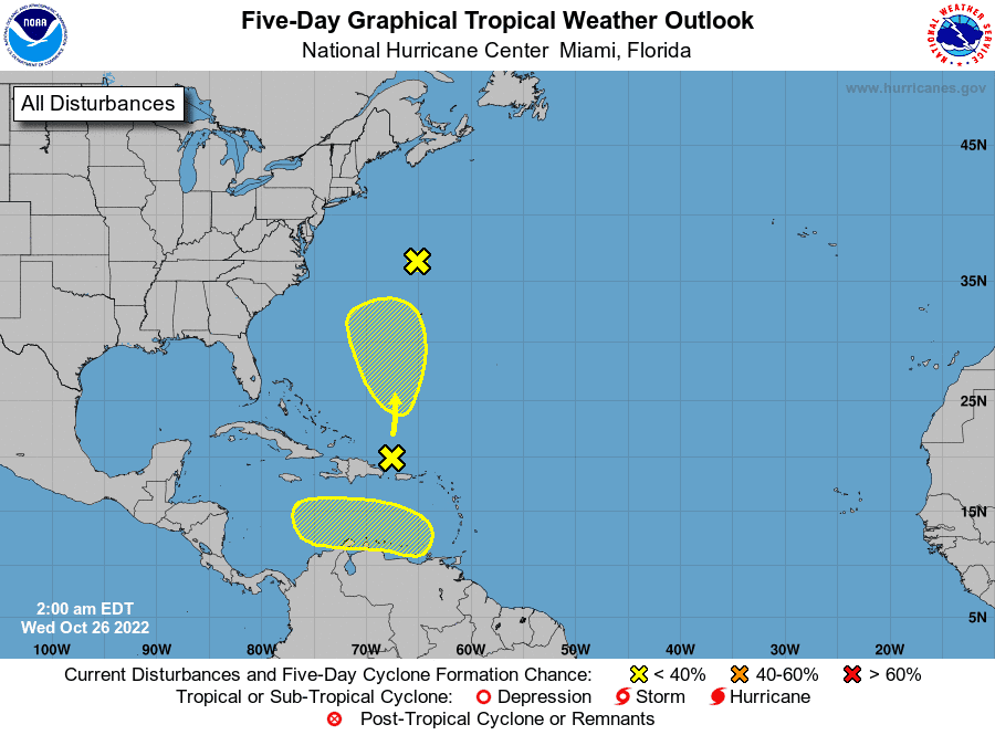
Tropical wave 1: Shower and thunderstorm activity remains limited in association with an area of low pressure located about 300 miles north of Bermuda. The system is accelerating northward towards cooler waters and into an area of strong upper-level winds, and development is no longer anticipated.
Formation chance through 48 hours: low, near 0 percent
Formation chance through 5 days: low, near 0 percent
Tropical wave 2: A trough of low pressure stretching from the central Caribbean northward to the southwestern Atlantic continues to produce a broad area of disorganized showers and thunderstorms. Environmental conditions appear conducive for some gradual subtropical development of this system over the next few days while it drifts north-northeastward. The system is then forecast to meander over the subtropical western Atlantic to the west or southwest of Bermuda.
Upper-level winds are forecast to become less conducive for development by the end of the weekend.
Formation chance through 48 hours: low, 10 percent
Formation chance through 5 days: low, 30 percent
Tropical wave 3: An area of low pressure could form over the eastern Caribbean Sea by early this weekend. Environmental conditions are forecast to be conducive for gradual development as the low moves generally westward or west-northwestward into the central Caribbean by the end of the weekend.
Formation chance through 48 hours: low, near 0 percent
Formation chance through 5 days: low, 30 percent
Who is likely to be impacted?
Currently, no systems are threatening the U.S.
Forecasters urge all residents to continue monitoring the tropics and to always be prepared during what's expected to be an active hurricane season.
When is the Atlantic hurricane season?
The Atlantic hurricane season runs from June 1 through Nov. 30.
When is the peak of hurricane season?

Although the season has gotten off to a quiet start, the peak of the season is Sept. 10, with the most activity happening between mid-August and mid-October, according to the Hurricane Center.
Weather watches and warnings issued for your area
If you can't see any local weather warnings here, you'll need to open this story in a web browser.
Tropical forecast over next five days
See the National Hurricane Center's five-day graphical tropical weather outlook below.
Excessive rainfall forecast
What's out there?
Systems currently being monitored by the National Hurricane Center.
What's next?
We will continue to update our tropical weather coverage daily. Download your local site's app to ensure you're always connected to the news. And look at our special subscription offers here.
This article originally appeared on Palm Beach Post: Tropics watch: NHC following three tropical waves in Atlantic, Caribbean

