The NC 12 conundrum: How do you maintain a vital OBX highway that keeps disappearing?
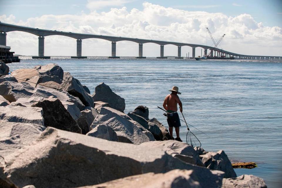
Jeff Ryder wishes everyone had a chance to drive over the Basnight Bridge into a storm.
He wishes you could know what it’s like to be arcing high over the Oregon Inlet with your pickup truck’s lights barely cutting the heavy darkness pressing in from all sides. He wishes that you could see the grains of sand flashing across your field of vision then disappearing again. He even wishes that you could strain your eyes attempting to find the center line for just an instant, that you could feel that moment of uncertainty when you wonder if your tires are still on the road.
“It’s like entering a world that you’ve never been in before,” Ryder said on a sunny June day, sitting inside his office in Manteo.
Ryder, the N.C. Department of Transportation maintenance official who oversees all of North Carolina’s Highway 12 through the Outer Banks, is confident that making that drive one time would be enough to convince people to never do so again in times of peril.
Ryder and his team take care of N.C. 12, a 148-mile, mostly two-lane road that runs from Corolla to Ocracoke before continuing on to Sea Level on the mainland. When a storm comes, it’s Ryder’s team that drives out in low tide to see what damage waves have inflicted on the road, and his team that piles into bulldozers to push sand off of the asphalt and back into dunes, trying to protect the road against an ocean that grows persistently closer.

Since 2010, the N.C. Department of Transportation has spent nearly half a billion dollars on N.C. 12.
Much of that — $420.8 million — has gone toward the construction of a trio of bridges, including the $252 million Basnight Bridge. NCDOT spent $61.95 million repairing and maintaining vulnerable sections of Highway 12 on Hatteras and Pea Islands, and another $15.97 million maintaining the 13 miles of road on Ocracoke that is linked to Hatteras via ferry.
The department is tasked not only with keeping the road open now against encroaching sand and sea, but also with envisioning its future on ever-shifting barrier islands pinched between the Atlantic Ocean and the Albemarle and Pamlico sounds. Climate change makes both of those tasks more difficult, particularly on the Outer Banks where sea levels are rising more rapidly than in other parts of North Carolina.
“As sea levels continue to rise and with water temperatures increasing(ly) leading to more frequent and severe storm events, the expectation is an increase in the need for maintenance until more permanent mitigation can be achieved through future projects,” Craig Midgett, a planning engineer for Northeastern North Carolina wrote in a June 2021 report.
Questions about how to protect N.C. 12 have lingered for nearly a hundred years, long before it got its highway designation. Sometimes protecting the road looks like sand dunes, other times like a local tax to pay for beach nourishment at one of the road’s numerous vulnerable points. When all else fails, it looks like abandoning a troublesome piece of the road entirely and building a bridge.
“There’s one way in and one way out,” Ryder said, “so you’re trying to maintain it or get it open as fast as possible to allow for the commerce to continue, the people to get to their doctors’ appointments, health care reasons, or just the basic travel and the livelihood of the area.”
Elizabeth Sciaudone, a civil engineering professor at N.C. State University, monitors the vulnerable stretch of N.C. 12 from the Oregon Inlet to Rodanthe. Some parts of that road will likely be under water within 40 years as Pea Island continues to erode, according to Sciaudone’s shoreline estimates.
Sciaudone can rattle off a series of hazards threatening the road — breaches of the entire island, flooding, overwash and wave impacts among them.
“There’s always long-term erosion, which is linked to changes in sediment transport and sea level rise,” Sciaudone told The News & Observer. “And wind-blown sand is also a problem, sometimes even when there’s not a storm.”
Constantly rebuilding a coastal highway
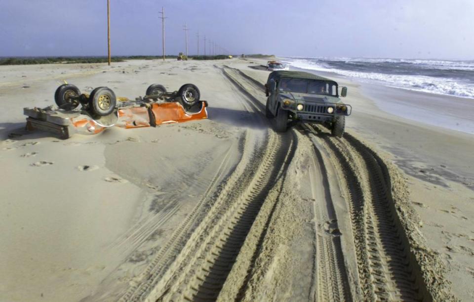
In November 2009, the remnants of Hurricane Ida led to a powerful nor’easter, causing water levels to rise six to seven feet above normal in the Outer Banks and destroying four homes.
Some of the worst damage from “Nor’Ida” happened just north of Rodanthe, in a portion of N.C. 12 known as the S curves. In that section of highway, a road that had taken a straight path through the Pea Island National Wildlife Refuge begins to wobble, veering to the west in places where some of the Outer Banks’ highest erosion rates have worn much of the shoreline away.
After Hurricane Ida, NCDOT moved about 1,860 feet of N.C. 12 to the west, pushing the asphalt as far away from the dangerous Atlantic as they could while remaining inside the 100-foot-wide corridor they are allowed to use by the U.S. Fish and Wildlife Service.
“That easement is a predefined corridor, it doesn’t shift with wherever you move the road. It’s kind of like the property line at your house, that doesn’t move. If you decide to move your house, that property line doesn’t move with you,” Pablo Hernandez, NCDOT’s district engineer for the region that includes N.C. 12, told The News & Observer.

NCDOT also lengthened a 900-foot section of sandbag-hardened dunes to 1,250 feet and conducted a beach nourishment effort around the S curves.
None of it worked.
In 2011, Hurricane Irene’s winds shoved water from the Pamlico Sound through the narrow strip of sand just north of Rodanthe, cutting a temporary inlet and isolating Hatteras Island. The storm also reopened a recurring inlet — known as New Inlet — on Pea Island, which is actually the northern end of Hatteras Island when the inlet is closed.
Just a year later, the S curves again suffered substantial damage when Hurricane Sandy passed by the Outer Banks. The storm was far out at sea but still powerful enough to cause two feet of flooding on low-lying parts of Hatteras Island and Ocracoke.
“I’ve rebuilt that road three times from 2009 to 2012,” Hernandez said of the S curves.

A bridge over the sound
Soon, there won’t be any S curves for Hernandez or Ryder’s maintenance crews to worry about.
The department is set to open a $154.5 million “jug handle bridge” this fall. The 2.4-mile bridge will bypass the S curves area entirely by arcing the road into Pamlico Sound just above where N.C. 12 starts to wobble on Pea Island, bringing it back to the island in northern Rodanthe.

Part of NCDOT’s decision to pursue a sound-side bridge instead of elevating N.C. 12 on Pea Island was the narrow corridor in which it could work. But another crucial factor is the ongoing erosion of the island around the S Curves, ranging from about 6.7 feet per year near their northern end to about 14 feet near Rodanthe, according to data from the N.C. Department of Coastal Management.
So far, the only traffic on the 17-foot, four-inch-tall bridge has been construction trucks and a temporary rail system built to carry cranes as they maneuver steel girders and huge concrete slabs into place. On a sunny, clear morning in late July, a person standing on the bridge deck could see a handful of cars driving on the current route of N.C. 12, feet away from the dunes with the Atlantic Ocean looming in the background.
When the bridge is complete, NCDOT will remove nearly 1.8 miles of pavement, some of which is feet thick where it has been paved over after storms. They will also remove about 2,200 giant, tubular sandbags that have been buried inside dunes to protect the road.
After that, this stretch of land will be left to the Atlantic.
In OBX, beach nourishment is ‘buying time’
Keeping a coastal highway intact often means thinking about sand.
After storms, it means pushing mounds of sand off of the road and back into dunes. In the slightly longer term, it can mean spraying sand across the Outer Banks’ famed beaches, bolstering the region’s tourism economy as the effort temporarily distances the Atlantic from oceanfront homes — and the highway behind them.
Since 2011, more than $150 million in beach nourishment projects have been conducted in Dare County, much of it funded through local tax revenue. Often, the explicitly stated purpose of these projects is protecting N.C. 12.
In 2014, an NCDOT project placed 1.7 million cubic yards of sand on the ocean side of the S curves, and Dare County funded a 2018 effort that placed 2.6 million cubic yards around the hotspot at Buxton’s northern end.
Next year, the county will pay an estimated $12.7 million to replace sand on a swiftly eroding section of Avon’s shoreline where dune lines have washed away, allowing tidal flooding to run down a secondary road and across N.C. 12.
“The beach nourishment project in Avon is more about N.C. 12 than anything else,” said Bobby Outten, Dare County’s manager.
Still, experts agree: Beach nourishment projects are not a long-term solution for the problems plaguing N.C. 12. Placing more sand on the beach doesn’t fix shoreline erosion, it just means the sand that’s washing away is further from homes and the road — while it lasts.
“It’s temporary, it’s buying time,” said Reide Corbett, executive director of East Carolina University’s Coastal Studies Institute. “But it’s doing just that: It’s buying them some time.”

Managed retreat, or wait for an emergency?
Spencer Rogers has spent about four decades thinking about N.C. 12. Rogers, a North Carolina Sea Grant coastal construction and erosion specialist, has provided NCDOT with guidance about the road on several occasions.
Generally, Rogers told The N&O, the agency’s management of the two-lane highway is a success story. The decision not to elevate the road, for instance, means that water washing over the dunes and onto the road is more likely to drain off without damaging the integrity of the pavement.
But sometimes, as with the new bridge to Rodanthe, NCDOT has needed to pull back from or rise above extremely vulnerable parts of the island. They are examples of a process that has been labeled “managed retreat,” which Rogers calls “a terrible marketing label.”
The S curves exist, for instance, because NCDOT could no longer protect the road in the middle of its 100-foot easement. And the department set about building the new bridge because it knew that even on the western edge of that corridor, the road remained vulnerable.

NCDOT took similar action between Avon and Buxton — another area where the island’s width can be measured in feet — after 1999’s Hurricane Dennis tore apart nearly a mile of pavement near Buxton, The News & Observer reported at the time. About 2.1 miles of roadway was shifted west, with sand dunes raised up on its ocean side.
“Once you get too close to the ocean, the storms on a frequent basis — annually or every couple of years — will undermine the pavement and you have to entirely rebuild the road,” Rogers said.
“So if you build it in the same location and it’s actively eroding, as most of the Outer Banks is doing,” he continued, “then the next storms are going to be even worse and you’re going to lose the pavement again.”
Kym Hunter, a senior attorney with the Southern Environmental Law Center, said NCDOT does not think nearly far enough into the future, especially considering that the road is built on ever-shifting sands with a rising sea on one side.
“I’ve worked on N.C. 12 issues for over a decade and during that whole time period, the focus has just been wait for an emergency, patch it up, throw some more sand on the beach, build everything back in the same place and in the meantime keep promoting development out there,” Hunter told The N&O.

Hunter said she would like NCDOT to build more bridges like the one around the S curves, effectively allowing the islands’ most vulnerable places to return to nature.
Dare County officials have asked Hunter to serve on a subcommittee exploring possible solutions for each of the hotspots. Hunter is joined on that committee by representatives from local governments, NCDOT and the Cape Hatteras National Seashore, among others.
“That made me hopeful that we can all work towards a common vision,” Hunter said. “I think the problem is going to be, this is an area where to do the right thing, you’ve got to invest real money, and I don’t know that that’s something North Carolina is necessarily willing to do.”
Don’t get stuck
In recent years, NCDOT has prepared studies evaluating potential solutions for the flood-prone areas of N.C. 12 on Pea Island, at Buxton and between Hatteras and Frisco. Ideas examined in the studies include long-term beach nourishment, bridges in the existing road corridor and new bridges into the Pamlico Sound.
If the department chose the lowest-cost option to repair all three of those hotspots, it estimated, work would cost $226.2 million. The most expensive estimates totaled $560.3 million.
NCDOT officials also looked at the northern end of Ocracoke, with long-term solutions involving new construction on the island ranging from $41.6 million for recurring beach nourishment to $284.45 million to build a bridge along the road’s existing path. The department has also considered moving its ferry terminal from the northern tip of the island, a proposal that has met some resistance among villagers and that NCDOT has estimated would cost upwards of $2 billion over the next 50 years.
But for NCDOT, building resilience doesn’t always mean more construction — in part because the department can only spend so much money.
Colin Mellor, who leads NCDOT’s environmental policy efforts in Eastern North Carolina and part of the Piedmont, has to think about how to best protect flood-prone parts of N.C. 12 and other barrier islands. But he also has to consider river flooding from heavy rainfalls in the Piedmont region and, occasionally, mudslides.
“We can’t build everything bigger, higher, longer,” Mellor said.
Resilience could mean giving maintenance teams like Ryder’s enough barricades to prevent drivers from endangering themselves on flood-prone roads, Mellor added. Or it could mean clearing pipes and culverts to make sure storm water can flow freely through them.
“It’s not always just building an elevated roadway out to the sound,” Mellor said, referring to the new Rodanthe bridge. “That’s the pinnacle right there.”
The ocean takes what it wants
When storms reach the Outer Banks, Mark Gawlinski is one of the NCDOT employees driving into what he calls “a sand out” to check the two-lane highway’s condition.
Gawlinski, a road maintenance supervisor who works for Ryder out of the Dare County Maintenance Yard, said the presence of NCDOT’s yellow trucks does not necessarily mean other drivers should be the road. During a storm two years ago, he pulled 10 different vehicles out of sand around the S curves.
“They end up going on the sand shoulder and it turns into quicksand,” Gawlinski said. “You’ll literally see a vehicle going good and all of a sudden it sinks up to the doors.”
Like others who work on the road every day, Gawlinski spends much of his time between Pea Island and Rodanthe, a section of road that features three hot spots, including the S curves. He said crews also work on the north end of Buxton and on the stretch of island between Frisco and Hatteras.
Sometimes, Gawlinski said, he will drop one load of sand from the road onto a dune only to watch five more come washing back towards him. Even if road crews get the highway open after a storm, he added, the high tide could come through and close it again.
Struggling with Nature has always been part of living on the Outer Banks. But it is growing increasingly hard — and sometimes impossible — to keep a strip of pavement intact on top of an island that wants to migrate west as the sea rises around it.
“The dunes can only hold back so much,” Gawlinski said. “There’s not a whole lot of beach out there, so … when the ocean wants to take it, it’s going to take it.”
Reporting for this story was supported by a Southeastern U.S. Ocean and Climate reporting grant from the Institute for Journalism & Natural Resources. This story was also produced with financial support from 1Earth Fund, in partnership with Journalism Funding Partners, as part of an independent journalism fellowship program. The N&O maintains full editorial control of the work.

