NC coast braces for 60 mph gusts, 20 ft breaking waves, and flooding as storm set to hit Outer Banks, Wilmington
RALEIGH, N.C. (WNCN) — As a major weather system with the risk of inches of rain and high winds approaches North Carolina early Sunday, the Outer Banks and other coastal areas are under a flood warning and high wind warning.
ALERT: Severe threat increases in central NC for Sunday’s heavy rain event
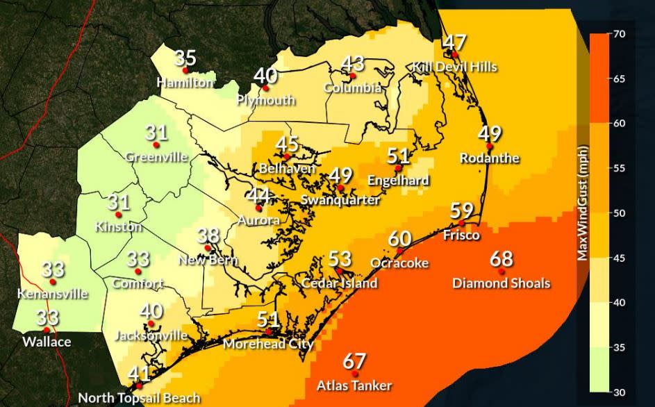
With up to 4 inches of rain possible, Dare County officials said Saturday that “large, dangerous surf is expected at all Dare County beaches.”
Beach erosion and overwash in areas along N.C. 12 are also expected. Officials warned that high winds — gusts up to 60 mph in Ocracoke and 51 mph in Morehead City — could damage outdoor items and cause scattered power outages.
Up to 3 to 6 feet of flooding above ground level is possible in low-lying areas near tidal waterways, the National Weather Service said in a coastal flood warning.
“Numerous roads may be closed. Low-lying property including homes, businesses, and some critical infrastructure will be inundated,” the warning said.
Areas around Wilmington, New Hanover County, and through Brunswick County south to Myrtle Beach will be under a high surf advisory with wind gusts up to 44 mph possible, the National Weather Service said.

In the Wilmington area and Brunswick County “large breaking waves of 8 to 11 feet are expected,” forecasters warned.
During the coastal flood watch in Wilmington, River Road about a quarter mile south of Cape Boulevard may be impassable and residential roads on each side of River Road south of River Road Park might experience minor flooding.
Water Street could be flooded from Red Cross Street to Orange Street with depths over a foot south of Market Street. Flooding could be worse on Point Harbor Road, U.S. Truck near Carolina Beach Road, N.C. 133 at Little Mallory Creek, and Old River Road at N.C. 133, the weather service said.

The problems at the coast are expected throughout the weekend and into Monday.
At the Outer Banks, a coastal flood warning is in effect from 8 a.m. on Sunday until 4 p.m. on Monday.
A high wind warning is in effect from 3 p.m. on Sunday until midnight. The warning includes areas near Morehead City.
A high surf advisory is in effect on Hatteras Island from 8 a.m. on Sunday through Monday.
“Large breaking waves of 10 to 20 feet (are) expected,” the surf warning said.
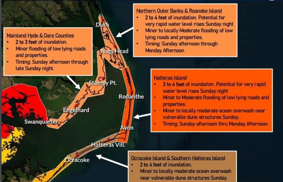
On the northern Outer Banks, the surf advisory is in effect from 4 p.m. on Sunday to 7 p.m. on Monday.
The warnings and advisories include Carteret County, Onslow County, Beaufort County, mainland Hyde County, Pender County, Ocracoke Island and Hatteras Island.
Cities and towns included in the warnings are Manns Harbor, Stumpy Point, East Lake, Washington, Chocowinity, Belhaven, Bath, Aurora, Engelhard, Fairfield, Ponzer, Scranton, Swanquarter, Duck, Southern Shores, Kitty Hawk, Kill Devil Hills, Nags Head, and Manteo.
For the latest news, weather, sports, and streaming video, head to CBS17.com.

