Tornado warning, flood alerts issued as storm system holds NC under state of emergency
- Oops!Something went wrong.Please try again later.
Gov. Roy Cooper declared a state of emergency over North Carolina Tuesday as a massive, forceful storm cloaking more than five southeastern states set in.
What to know.
Charlotte-area, NC forecast, tornado warnings Tuesday
Just before 2 p.m., a suspected tornado killed one and injured two near mobile homes about 40 miles north of Charlotte in Catawba County.
The National Weather Service issued a tornado watch in Mecklenburg, Gaston, Union, Cabarrus, Rowan, Anson, Stanly, Montgomery and Richmond counties. It will remain until about 6 p.m.
Meteorologists earlier warned of a possible tornado south of Interstate 85.
Tornado warnings were also issued for Indian Trail, Matthews and Mint Hill until about 3 p.m. The area holds at least 470,00 people, 72 schools — all closed Tuesday — and two hospitals.
Union County also fell under a tornado warning just after 3 p.m., when meteorologists detected rotation in a “severe thunderstorm capable of producing a tornado.” The alert expired at 3:45 p.m.
While North Carolina’s tornado watches and warnings concentrated in the counties surrounding Charlotte, the alert extended to much of South Carolina, eastern Georgia and northeast and north-central Florida.
Flash flood warnings
The NWS issued flash flood warnings near Charlotte, Fort Mill and Huntersville until about 6 p.m. Indian Trail. Monroe and Waxhaw are under the same warnings until about 7 p.m. Warnings for Salisbury, Mooresville and Statesville aren’t expected to expire until 9 p.m, and Concord’s won’t expire until 10 p.m.
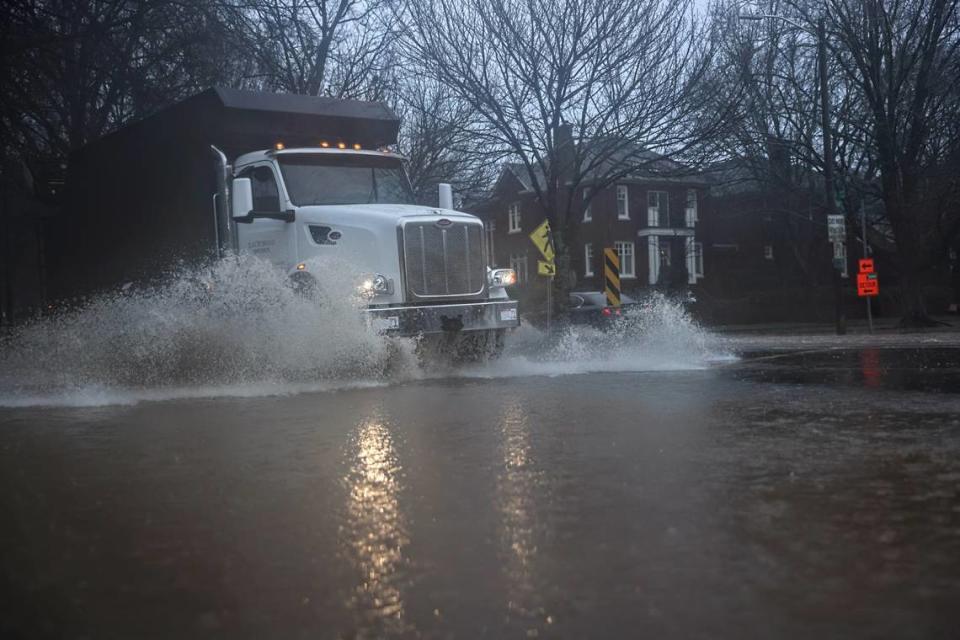
By 4 p.m., rainwater and overflowing construction run-off flooded many Charlotte streets:
Around 4 p.m., Charlotte Fire launched a rescue boat onto a flooded Shamrock Drive in east Charlotte, reported WSOC, The Charlotte Observer’s news partner.
Commonwealth Avenue, a Plaza Midwood corridor, also badly flooded around 3 p.m.
Charlotte’s NoDa neighborhood — currently littered with construction sites promising new apartments — flooded, leaving a small car in need of a tow Tuesday afternoon, reported WSOC, The Charlotte Observer’s news partner.
Before 3 p.m., the exit from Interstate 85 southbound to I-77 southbound flooded, WBTV reported.
Wilkinson Boulevard was one of the first roads to flood in the Charlotte area. A stretch of the main road leading up to Charlotte Douglas International Airport was also closed with only one westbound lane open just before 3 p.m.
Downed power lines closed East Independence Boulevard, a busy Charlotte highway, in both directions for 1.5 miles from Windsor Square Drive to Matthews-Mint Hill Road before 3 p.m.
Authorities warned the floods could affect more than 1.3 million people, 227 schools and 12 hospitals. The NWS recommends moving to higher ground and avoiding walking or driving flood waters.
Heavy rain could lead to landslides in western NC. Here’s what to know, how to stay safe
Strong winds, power outages and storm damage reported

Meteorologists Monday predicted the storm system — expected to bring winds with speeds between 20-30 miles per hour and gusts of up to 50 miles per hour — would drench the already saturated area with up to four inches of rain near Charlotte.
Gusts up to 75 miles per hour were expected along the Tennessee border, in higher elevations across the mountains and in coastal areas, officials said Tuesday morning.
“The main issue is that heavy rain will saturate the soil, and the prolonged gusty winds could topple trees and power lines,” Jeffrey Taylor, a meteorologist at the National Weather Service office in Greer, told The Charlotte Observer.
Charlotte’s Cotswold neighborhood saw that happen when a large tree took down power lines and smashed a truck, WCNC reported.
By 2:30 p.m. Tuesday, about 60,000 Mecklenburg County residents were without power, according to Duke Energy’s outage map. Gaston College, located about 25 miles west of Charlotte in Dallas, lost power around 11 a.m. Tuesday.
“The Governor and NC Emergency Management officials are urging North Carolinians to be safe and cautious during heavy rainfall and winds, and to expect flooding and power outages as a strong weather system will impact the state Monday evening and Tuesday,” Cooper’s administration wrote in a news release.

Heavy rain could cause river overflow
Most rain was expected to fall before 4 p.m., with storms lasting until about 6:30 p.m., according to the NWS. Both gusts and surface winds will peak around 3 p.m.
Meteorologists warned rainfall in the South Fork Catawba watershed will “overwhelm saturated soils and result in excessive runoff and significant stream rises” across southeastern Burke County, Catawba County, Lincoln County and Gaston County. Several small tributaries of the South Fork Catawba River will likely overflow, causing minor to moderate flooding as early as late Tuesday morning.
Stay inside: Restaurants, bars and venues closed during Charlotte’s inclement weather
School cancellations, closed businesses, airport, flight delays
The storms, which cover northern Florida, southern Alabama, central and northern Georgia and eastern Tennessee, caused Charlotte-Mecklenburg Schools, surrounding districts and some private schools to shutter schools Tuesday. The closures forced major changes to high school basketball schedules.
Charlotte-area business owners hunkered inside with altered hours or closed altogether. Cornelius closed its Town Hall and parks and recreational facilities. At 11:30 a.m., Mecklenburg County closed its offices, expecting to resume operations at 8 a.m. Wednesday.
As of about 4:30 p.m., more than 50 flights were canceled and nearly 500 were delayed out of Charlotte-Douglas International Airport, according to FlightAware.
Sewage spills during storm
Charlotte Water staff responded to these wastewater overflows during the heavy rains, spokesperson Cam Coley said:
Near 1634 Hugh Forest Rd., about 1,050 gallons reached Four Mile Creek in the Catawba River Watershed due to a pipe failure.
Near 739 Stanfield Drive, about 1,800 gallons, out of 3,600 gallons, reached Little Hope Creek in the Catawba River Watershed due to a pipe failure and tree roots.
At the McAlpine Creek Wastewater Treatment Plant, 12725 Lancaster Hwy. in Pineville, the rains caused an undetermined amount of wastewater to overflow.
“Normally, we treat 85 million gallons of the community’s wastewater daily,” Coley said in a statement. “Yesterday, we treated 220 million gallons. Big thanks to the operators and crews.”
In Mooresville, about 10,800 gallons of untreated wastewater spilled into Reed Creek from the Reed Creek Pump Station, 253 Golf Course Drive. The overflow was due to flash flooding from at least two inches of rain that fell in a short period, town spokeswoman Megan Suber said.
“The spill was not of a magnitude to cause immediate danger to human health or the environment,” Suber said in a statement.

