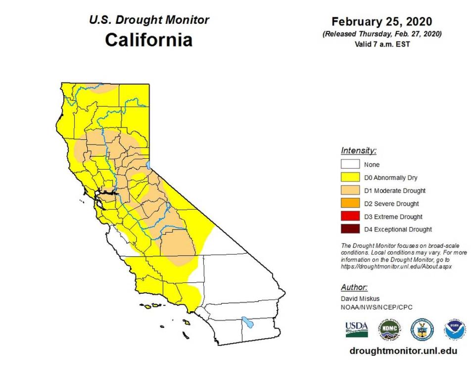
Nearly 25 percent of California in ‘moderate drought’ status, federal monitor says
Hours before California water officials measure the Sierra snowpack for the third time in 2020, the latest data released by a consortium of federal agencies says almost one-quarter of California’s land area is now in “moderate drought” status, including essentially all of Sacramento County.
More than 23 percent of the state is considered to be at a moderate drought level, up from just under 10 percent one week earlier, according to weekly maps released Thursday by the U.S. Drought Monitor.
The drought area has expanded from a patch of the San Joaquin Valley to include most of the Sacramento Valley, parts of the central Sierra Nevada range and surrounding foothills, about half of Mendocino County along the north coast and a small portion of Siskiyou County at the state’s northern border, the map shows.
An additional 43 percent of California is “abnormally dry,” the recent map shows. About 70 percent of the state, including effectively all of Northern California, is either abnormally dry or in moderate drought, according to the monitor, which was published Thursday with data valid from Tuesday. On the last day of 2019, less than 4 percent of the state was mapped as abnormally dry.
Those numbers come as Northern California winds down one of the driest Februaries in recorded history. The San Jose Mercury News on Thursday reported that the Bay Area is on track for its lowest February rain total since 1864.
On Thursday, state water officials at Phillips Station recorded a snow-water equivalent of 11.5 inches, only 47 percent of average for the end of February, according to Sean de Guzman, chief of snow surveys for the California Department of Water Resources, who announced the results Thursday morning in a live stream to Facebook.
Statewide snowpack is a tick lower at 46 percent of average for this time of year, according to data dug up by those electronic sensors.
DeGuzman called the month’s minuscule rain and snow totals “quite disappointing,” noting that it will almost certainly go down as the driest February ever measured by DWR officials in the Northern Sierra Nevada range over 99 years of recorded history.
Will Sacramento get rain?
Sacramento has been devoid of precipitation since Jan. 26 and is on pace for the driest February in recorded history, a record dating back to 1899 when the capital city got just 0.04 inches.
National Weather Service forecasts now show that a literal last-minute patch of late-night showers could, possibly, at least save Sacramento from a completely dry month. The forecast predicts about a 20 percent chance of very light showers rolling in after 10 p.m. Saturday, the calendar’s bonus day for leap year. Light rain showers with less than two hours left in the month, though, could still very easily come in under 0.04 inches.
Before and after Saturday, Sacramento is forecast to be sunny and warm. Thursday’s anticipated afternoon high of 77 degrees would set an all-time record for the date, and after a weekend cooldown to the 60s, temperatures are set to trend back near 70 degrees by the start of next week.
Percent of average rainfall across the state as of yesterday. Most of our sites are between 40-70 percent of normal for the water year so far.#cawx pic.twitter.com/sbbpwGSIg7
— NWS Bay Area (@NWSBayArea) February 26, 2020
So is California in a drought?
The U.S. Drought Monitor, which is compiled using data from multiple federal agencies including the National Oceanic and Atmospheric Administration, says that an estimated 5.9 million Californians are currently residing in drought areas.
However, it typically takes multiple dry winters to bring about a statewide drought, which is an emergency that the governor would have to declare. The most recent, official drought stretched from 2011 to April 2017, when former Gov. Jerry Brown declared it over.
The drought monitor’s “D1” moderate drought classification is described as dryness that can stunt pasture growth, change wildlife patterns and drop ponds and creeks below their normal levels.
Even the “D0” abnormally dry designation, though, can mark the beginning of “active fire season,” a legend for the map said. Climate experts told The Sacramento Bee earlier this month that the dry start to 2020 could increase wildfire risk later in the year.
Listen to our daily briefing:

