Nearly 400 acres to be rezoned in Sneads Ferry for residential, concerning residents nearby

The Sneads Ferry area will continue to see growth following the approval of a rezoning request that will turn nearly 400 acres into a residential development.
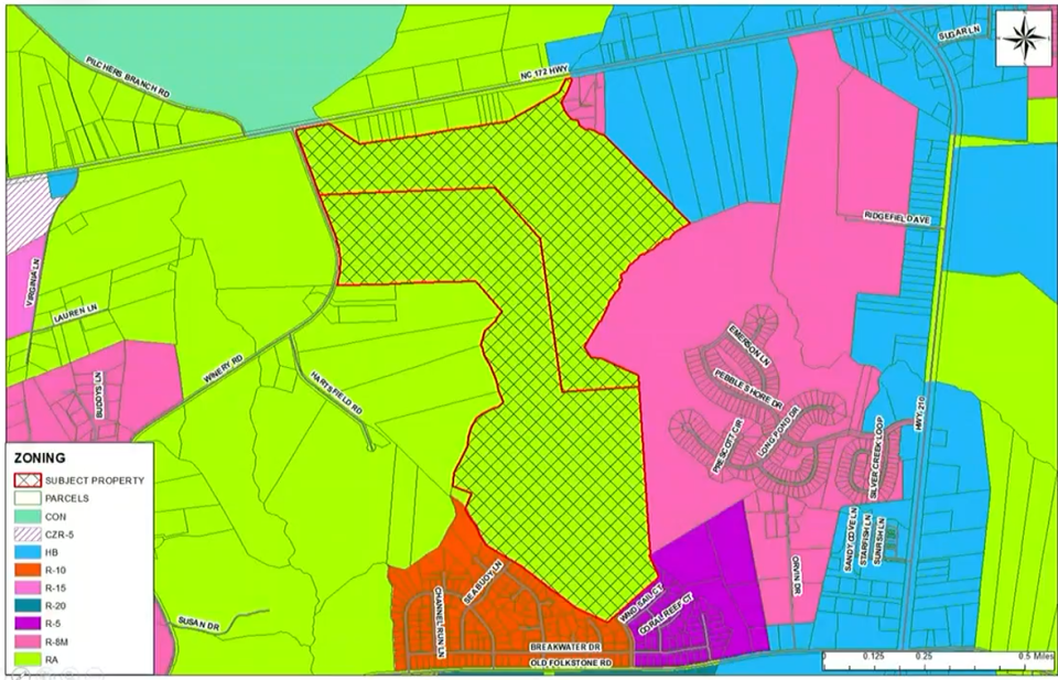
Developer DR Horton, Inc., a home construction company headquartered in Arlington, Texas, has applied and received approval from the Onslow County Board of Commissioners to rezone 386.56 acres of rural agriculture land on the south side of N.C. Highway 172 and the east side of Winery Road to residential.
Major development: Four projects bringing more than 1,300 homes to Jacksonville, Richlands
'Truly a great resource': Onslow County taking advantage of program for transitioning military
The purpose of zoning is to accommodate moderate-density single-family residential development in suburban areas of the county that have access to utility and transportation infrastructure necessary to support development at a suburban scale and intensity, according to the planning board.
Although the rezoning is part of the Sneads Ferry Community Plan, which was created in 2015 as a guide for developing land in Sneads Ferry, some residents expressed concerns about the development, with one specifically discussing her concerns when it came to overcrowding in schools.
Impact on local schools - already overcrowded?
The land has ONWASA water and Pluris Sewer already available, fire service will be provided by Turkey Creek, according to Onslow County Planning and Development Director Jessica Rhue. These are some of the things that make the land ideal for families and fit the purpose of rezoning.
However, the increase in traffic and already-high population in local schools have residents worried. Rhue emphasized that schools are not overlooked in this process.
She said the rezoning process will include the use of a tool called plan residential development. That tool will make sure agencies like the school district have a say in the rezoning.
"You kick in our subdivision ordinance and you also are going to kick in a major site plan which is going to go through a very intense technical review where it is evaluated by the schools, the applicable utility companies, the fire station that applies to this area, the NCDOT, especially in this case since we are on a state highway, all of those things are reviewed," Rhue said, adding there are about 32 different agencies who have the chance to evaluate the plan.
The school system has provided the planning board with a formula to help determine the reasonable impact of a volume of students in comparison to the amount of acreage.
"Of course, in our community, that adds more elementary school students typically, because we have a lot of young families due to the military base and slightly fewer middle schoolers and high schoolers," Rhue said. "That always is reflected for you (the board) as well and that data is included and sent to the school system even if they do not come and attend in person."
Rhue said the number of students in the new development based on that formula is reported to be potentially about 400 students. She added that will be about half elementary school students, a quarter of middle school students and a quarter of high school students.
However, this could change after the major site plan is submitted and reviews from agencies and planning staff kick in.
Part of the reason the planning board feels confident about making this land residential, Rhue said, is due to the already current zoning in the area, to the east.
"We look at our land use plan to consult that when we're making rezoning decisions," Rhue said. "This has split categories in our land use map. We have medium-density residential and we have a community growth area. Both of those support the proposed zoning. We also look at our Sneads Ferry Community Plan which has this in a traditional neighborhood classification which also does support this request."
Plan has been reworked several times
This rezoning request has actually been in the works for the last six months, as DR Horton, Inc. initially requested to rezone the land with a higher density. The current number of homes approved is unknown.
Rhue said the planning board discussed this rezoning four times before unanimously recommending the residential zoning for this area at their meeting on July 7. At that meeting, no one spoke against it. At two meetings prior to that, there were some concerns about the developer's plans, hence the changes.
Commissioner Royce Bennett said he appreciated the applicant's willingness to concede and change their application to meet the needs of the community.
Vice Chairman Tim Foster said many people think residential immediately means more single residential homes. However, he said there will also be the opportunity for multi-family homes such as townhomes. The concerns he's heard from residents include the infrastructure in Sneads Ferry as well as potential issues with schools, sewer, water, etc.
"I think another thing that's important is that you can't just take the volume of acreage and divide it by 15,000 square foot lots," Rhue said. "It's very easy to assume we're going to do that. There are so many more things that get looked at when you kick in a subdivision ordinance and that is by design. In addition to that, of course, any development over an acre is going to the state to be looked at for environmental concerns and stormwater."
Onslow County drivers get their answer: yearly emissions tests to stop in the coming weeks
Local news: Jacksonville veteran from famous 2008 war photo urges struggling Marines to ask for help in book
Rhue added the county also has more scrutiny in areas with blue-line streams, which this rezoning does involve, due to environmental impacts.
Commissioner Buchanan emphasized the importance of trying to help protect homeowners, specifically due to already existing developments in Onslow County that can't be fixed.
Rhue said when the planning board redid their subdivision ordinance in 2020, they really paid attention to what they could do to provide assurance that the community was going to grow sustainably. One of those items addressed was making sure streets were turned over.
In the state of North Carolina, counties do not control roads, Rhue said.
"They either have to be privately maintained roads, which we have safeguards for in private communities now which are relatively difficult to meet, or they need to meet those NCDOT standards," Rhue said. "When you meet a certain threshold, the road is required to be turned over to the state for maintenance. We do, unfortunately, have several communities in Onslow County which were developed prior to zoning and prior to subdivision regulations which did not have that assurance and we wanted to make sure that moving forward that never happened again."
Reporter Morgan Starling can be reached at mstarling@gannett.com
This article originally appeared on The Daily News: Nearly 400 acres to be rezoned for residential in Sneads Ferry

