‘Nearly impossible road conditions’ Sunday for some Midlands counties, forecaster says

The National Weather Service said that Sunday morning may have “nearly impossible road conditions” for northern Midlands counties, as freezing rain and snow roll into South Carolina.
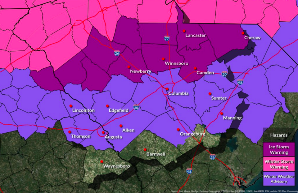
Those counties include most of those north of Interstate 20 such as Newberry, Fairfield, Lancaster and Kershaw counties.
On a social media broadcast, a National Weather Service meteorologist said Saturday afternoon that the time for making preparations is now in those northern Midlands counties.
Most of Newberry, Fairfield and Lancaster are set to see the most significant impacts of the ice storm in the Midlands, the meteorologist said. In those areas, travel will be “very dangerous” on Sunday.
A winter weather front is rolling into South Carolina between Saturday night and Sunday, forecasters have said. Rains will come in on Saturday night and turn into snow and freezing rain between 3 a.m and 7 a.m. Sunday. In the Upstate snow is expected, but in the Midlands freezing rain and wind gusts are predicted.
Widespread and extended power outages are possible, the National Weather Service meteorologist said.
Forecasters “are concerned” about road conditions in Richland and Lexington counties, including the Columbia area, on Sunday and Monday.
In the latest forecast, meteorologists haven’t changed a winter weather advisory for Columbia, Lexington and most of the Midlands counties south of Interstate 20 as of Saturday afternoon. Those areas could see freezing rain.
But counties north of I-20, including Newberry, Fairfield and Kershaw are expected to get ice storms. The National Weather Service still have an ice storm warning for those areas as of Saturday afternoon.
