These Nerds Saw Ukraine Invasion Start On Google Maps Before Putin Said a Word
- Oops!Something went wrong.Please try again later.
The world saw Russia’s buildup to war on a dance app. But it was a traffic app that tipped off a handful of researchers in California that the invasion was underway even before Russian President Vladimir Putin made the announcement late Wednesday night.
For months leading up to the invasion, TikTok users in Russia and Ukraine posting videos of Russian armored vehicles went from a trickle to a flood on an app usually reserved for twentysomethings dancing to viral song clips.
But the first public tipoff that Russia’s invasion of Ukraine had begun—even before Putin’s early-morning declaration of war—came from a handful of academics watching a traffic jam develop on Google Maps’ traffic monitor right next to an encampment of Russian military vehicles south of Belgorod, a town in Russia near the Ukrainian border.
Moscow has repeatedly banned mobile devices and social media use among its troops in an attempt to prevent this exact scenario. But the availability of real-time information about Russian troop movements and the start of a war highlights just how much even basic consumer technology has made military secrets harder to keep.
Jeffrey Lewis, a scholar at Middlbury’s Institute of International Studies whose team first found the dash towards the border, says mobile device bans won’t necessarily help militaries keep all their secrets safe.
“It’s a reasonable step to take but it doesn’t solve their problem,” he told The Daily Beast. “We live in an era where all of our patterns of life are digitally recorded and recognized. Even if Russian troops turned their phones off, the disruption that they caused was a deviation from the normal pattern of life that we immediately recognized in the form of ‘there aren’t traffic jams at 3 in the morning.’”
Biden Unveils Stiff Sanctions Against Russia for War Putin ‘Chose’
The Middlebury team began their vigil late Wednesday as rumors that the invasion might start that evening reached a peak. At 3:15 a.m. local time in Belgorod, John Ford, a graduate research assistant at Middlebury, found something unusual—a traffic jam visible on Google Maps right next to the E105 highway, which runs from Norway through Russia and down to Crimea.
Google is able to provide real-time updates on traffic conditions by monitoring location data uploaded from phones with the app installed and the presence of a traffic jam so late at night seemed suspicious. A small number of local vehicles appeared to be having trouble moving down the E105, triggering the app to show a traffic jam. As the Middlebury team saw the holdup move down the highway towards Kharkiv in Ukraine, they knew they were onto something.
The researchers hadn’t stumbled on the traffic jam by accident when looking across the hundreds of miles of border between Ukraine, Belarus, and Russia. Instead, they were watching the exact location of the traffic jam thanks to tip-offs from the high and low arts of open source intelligence work, synthetic aperture radar (SAR) and TikTok.
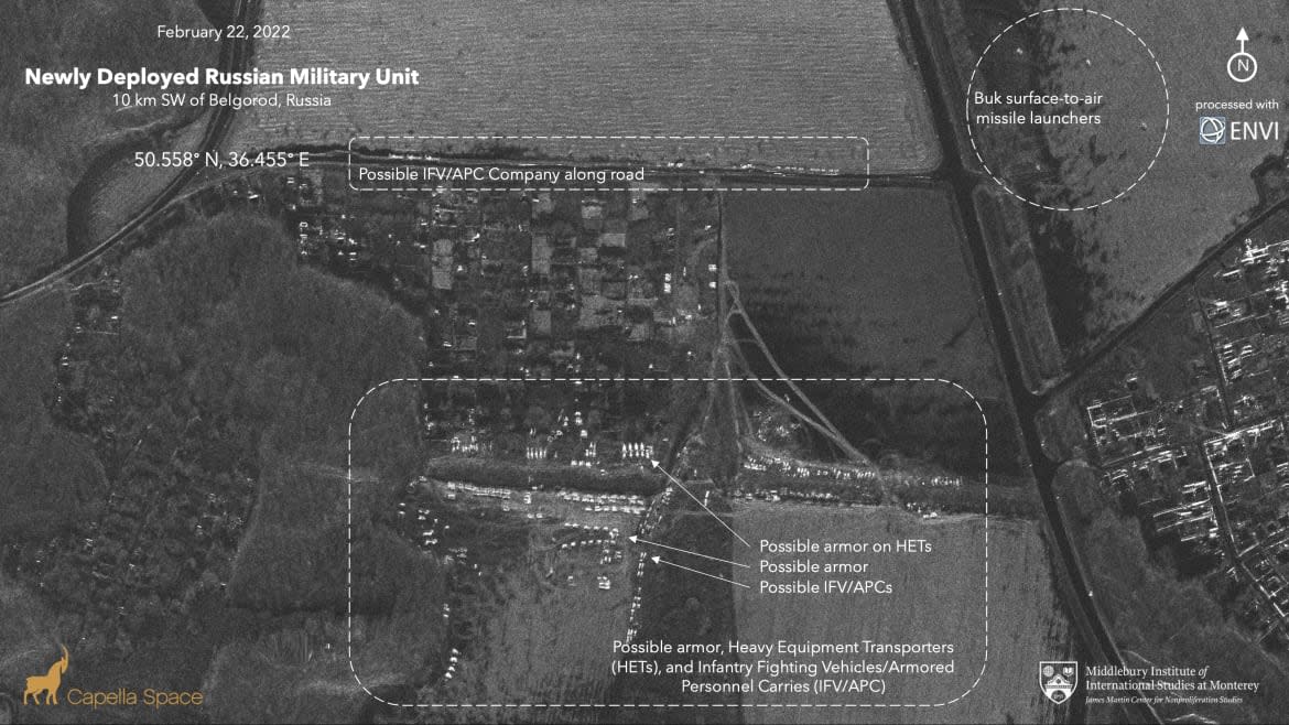
In the days before the invasion, Steven De Le Fuente, a Middlebury research assistant, combed through a catalog of imagery provided by Capella Space satellites capable of taking pictures with radar waves. SAR imagery is especially useful for seeing what’s on the ground when the skies are filled with clouds. Radar waves penetrate through those clouds and bounce back to form a coherent picture where the beams of light that illustrate regular satellite pictures show only puffy, obscuring blotches.
Over the past two weeks, satellite imagery showed large numbers of vehicles and troops pouring into Belgorod, just a little over an hour north of the Ukrainian city of Kharkiv, which U.S. intelligence officials warned could be one target of a Russian invasion. De La Fuente found one particular formation of Russian tanks, surface-to-air missile launchers, and armored personnel carriers near the E105.
“It’s the skeleton key that unlocked the analysis because the day before we saw a large Russian armor unit forming up along the road, which is what you would see prior to an attack. We did not see any evidence that they planned to stay. There were no tents,” Lewis said.
And just in case there was any doubt, a TikTok user had helpfully uploaded dashcam video, complete with Russian hard rock soundtrack, showing the surface-to-air missile launchers seen in the radar imagery parked on the E105, confirming equipment and location.
The traffic jam crept closer right up to the border with Ukraine until Putin made an abrupt appearance on Russian TV at 5:45 a.m., Moscow time, to declare war on Ukraine and his intention to topple its government. The traffic jam then cleared and disappeared and shortly afterwards, web cameras in Kharkiv, showed explosions on the horizon outside the city.
Since the war began Thursday, social media is now overflowing with images of Russian weapons and troops assaulting Ukraine. But Lewis and his team are still using the Google Maps traffic monitor to keep track of another grim development in the conflict—traffic jams around the country as civilians flee cities in hopes of finding shelter from the fighting.
Get the Daily Beast's biggest scoops and scandals delivered right to your inbox. Sign up now.
Stay informed and gain unlimited access to the Daily Beast's unmatched reporting. Subscribe now.

